(BIVN) – Before Episode 31 in the ongoing Kīlauea summit eruption sent inclined lava fountains across Halemaʻmaʻu crater, scientists published an article on the new vent observed during Episode 30.
From the Volcano Watch article, written by U.S. Geological Survey Hawaiian Volcano Observatory scientists and affiliates:
The past eight months have provided the Island of Hawaiʻi with spectacles of lava fountains at Kīlauea’s summit. These historic episodes began on December 23, 2024, consistently offering locals and visitors a stunning display of lava fountaining nearly weekly. With the 30th episode, came one of the most significant changes since the eruption started — a new fissure in the caldera wall.
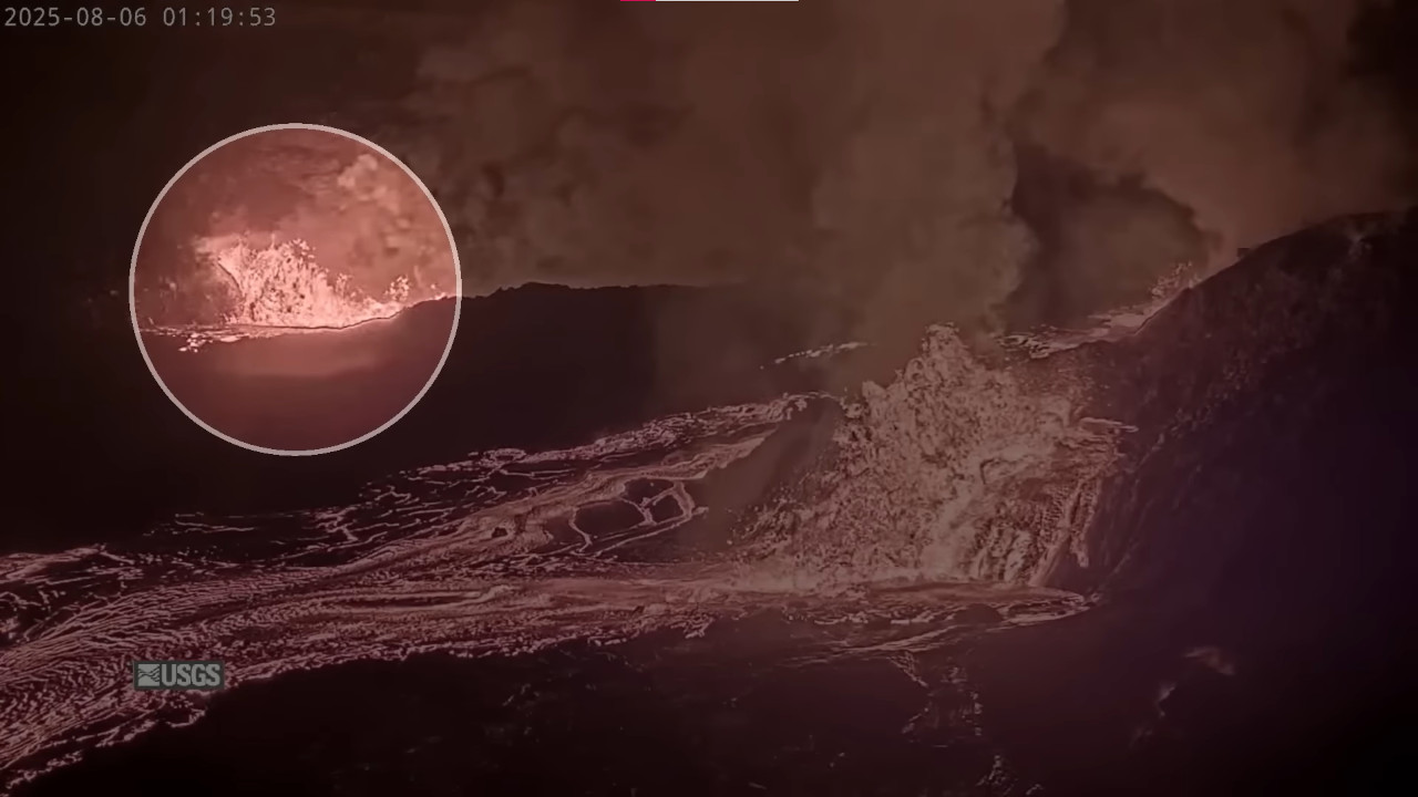
The new vent seen in a USGS webcam during Episode 30
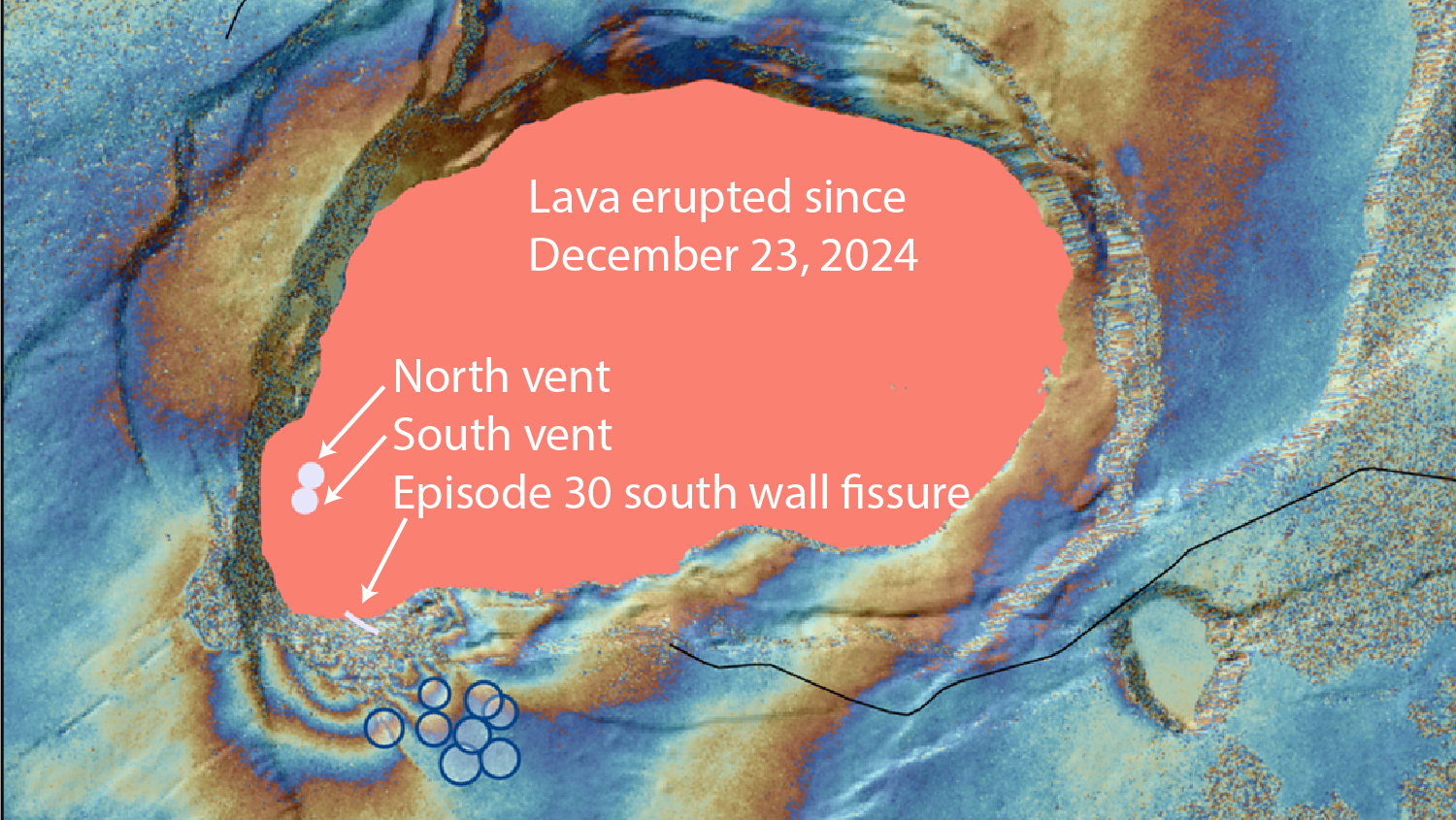
While monitoring data has shown some changes during and between lava episodes, much of this eruption has displayed consistent patterns overall. Two eruptive vents, the north and south, in the southwest part of Halemaʻumaʻu crater have erupted lava fountains feeding lava flows onto the crater floor. These vents have sometimes alternately or simultaneously erupted, with changes in their geometries over time such as growth of the cones around the vents. Nonetheless, the deformation pattern at the summit has been consistent, with inflationary deformation leading up to a fountaining episode, followed by pressure release and deflation during the fountaining itself.
The dominant seismic signal has been tremor, a signal associated with fluid movement (such as magma or gas). Tremor has been weak and occurs along with low-frequency bursts between episodes, then transitions to high-intensity eruptive tremor during the fountaining. Notably, volcano-tectonic earthquakes (brittle fracture) have been infrequent around Kaluapele (Kīlauea’s modern caldera) during this eruption, resulting in overall low earthquake counts.
Episode 30 began differently than other episodes, with the Uēkahuna Bluff tiltmeter showing deflationary tilt prior to the start of the episode at 12:45 a.m. HST. Ten minutes later, lava first appeared in the north vent and began overflowing it within a minute. At 1 a.m., the Sand Hill tiltmeter began recording rapid tilting away from the caldera and shallow earthquakes began the area just to the south of the Halemaʻumaʻu vents.
Magma then became visible in the south vent at 1:07 a.m. followed by the opening of a new fissure on the south side of Halemaʻumaʻu crater and accompanied by one of the largest earthquakes at 1:12 a.m. The south vent began erupting a minute later followed by the onset of vigorous, high-volume fountaining from the north vent accompanied by strong tremor at 1:20 a.m. At this point, the Sand Hill tiltmeter switched from tilting away from the caldera to inward and the earthquakes stopped.
The combination of the rapid swarm of volcano tectonic earthquakes and the southward tilt of two microradians seen at Sand Hill recorded the opening of a new subsurface crack. Magma rose rapidly within the crack and in less than 12 minutes erupted on the surface creating the new fissure vent opening in Halemaʻumaʻu. This new vent stopped erupting after only 4 hours but still represents a significant change in the eruption.
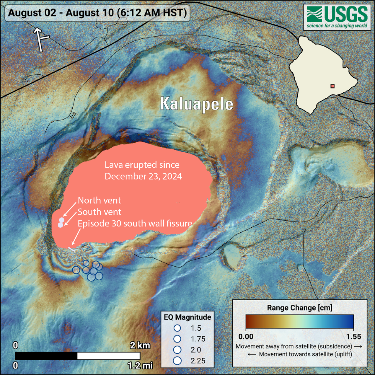
USGS: “COSMO-SkyMed Second Generation (CSG) interferogram for the period from August 2 to August 10, 2025, covering Kīlauea volcano’s summit region. Each color fringe represents 1.55 centimeters (0.61 inches) of ground movement in the direction between the satellite and the ground (range change). The symbol in the upper left indicates the satellite’s orbit direction (arrow) and look direction (bar). Earthquakes are marked with circles with the size proportional to their magnitude. The lava flows covering the crater floor are represented by the pink polygon, the two vents (circles) and the new fissure (line) are marked in light pink.”
A radar interferogram spanning episode 30 shows permanent ground movement near the new eruptive fissure and the area where the earthquakes took place. The ground moved southwest (toward the satellite, during its south-to-north flight) on one side of the fissure, and to the northeast (away from the satellite) on the other. This is shown by repeating color cycles called fringes (see this December 2024 Volcano Watch). The abrupt termination of some of the fringes suggests the ground moved along existing caldera ring faults and ground observations confirmed that new cracks were also created, extending well beyond the new fissure onto the rim of the crater. These observations indicate that the new fissure was fed by a shallow magma (less than half a mile or 1 km deep) that intersected the surface at and near the southern wall of Kaluapele.
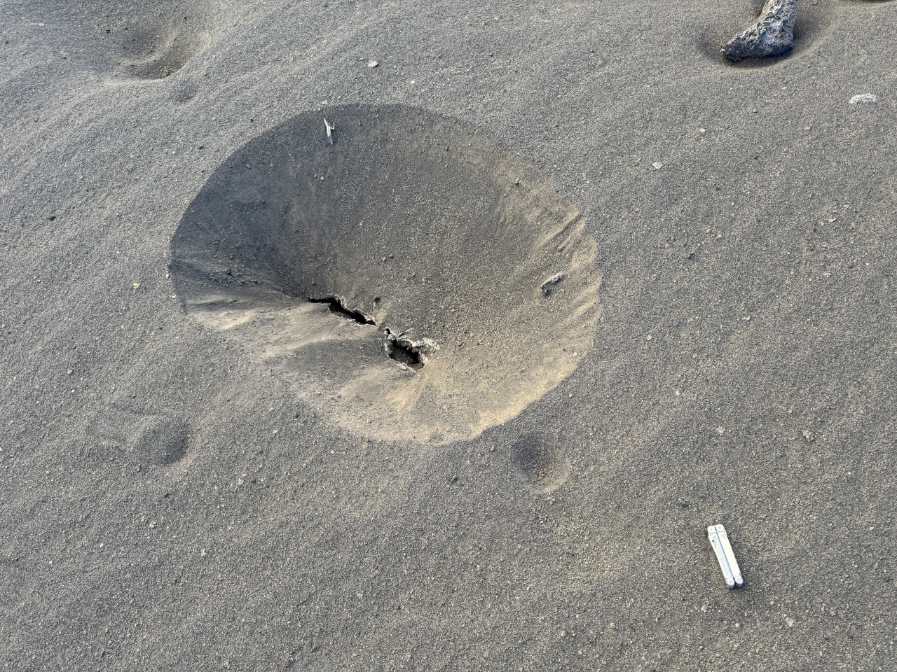
USGS: “On the south rim of Halemaʻumaʻu, new sink holes in ash and tephra that blankets the ground in this area were observed following episode 30 of the Kīlauea summit eruption on August 6. The sinkholes formed due to underlying cracks that opened as a result of the new fissure in the south wall of the caldera.” (USGS photo by M. Patrick)
Episode 30 behavioral changes serve as an important reminder that while the current eruption has appeared consistent and repetitive, volcanic systems can evolve rapidly, potentially leading to new hazards in areas surrounding the eruption site. At Kīlauea summit, new fissures and cracks may form, and large, fractured cliffs may become unstable and suddenly fall into the caldera. This underscores the hazardous nature of the closed area west of Halemaʻumaʻu, in Hawaiʻi Volcanoes National Park. While residents and visitors enjoy the beautiful spectacle that this eruption has provided, safety should always be a priority and visitors should heed National Park Service guidance.

by Big Island Video News
on at
STORY SUMMARY
HAWAIʻI VOLCANOES NATIONAL PARK - Scientists wrote about the new fissure that emerged in the caldera wall during Episode 30 of the Kīlauea eruption.