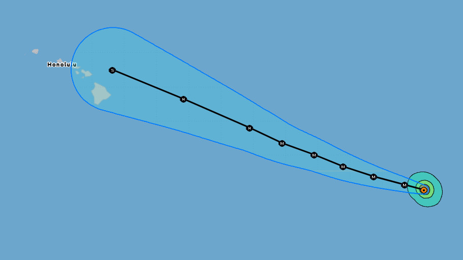
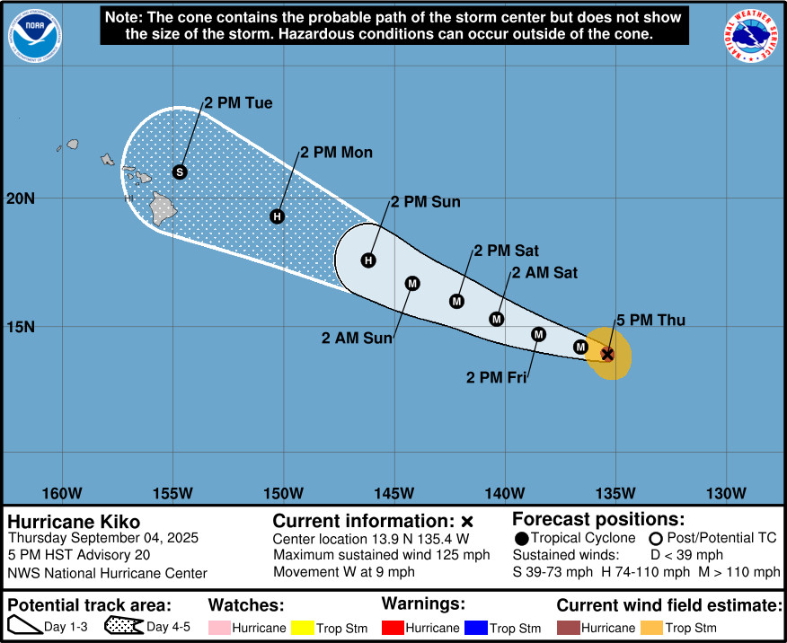
(BIVN) – Hurricane Kiko – 1,360 miles east southeast of Hilo as of 5 p.m. Thursday – has weakened slightly as it moves west at 9 mph. With maximum sustained winds near 125 mph, Kiko is now a category 3 hurricane on the Saffir-Simpson Hurricane Wind Scale.
The National Hurricane Center says some strengthening is possible tonight and Friday, followed by slow weakening Friday night through the weekend. Swells generated by Hurricane Kiko could begin reaching Hawaiʻi shores towards the end of this weekend.
Forecasters are saying interests in the Hawaiian Islands should monitor the progress of Kiko.
“Currently, it looks like a band of dry air will fill in on Monday before moisture associated with Hurricane Kiko fills in from the east on Monday night,” the National Weather Service in Honolulu reported Thursday afternoon. “The (National Hurricane Center) is currently forecasting Kiko to pass just north of the Big Island as a Tropical Storm on Tuesday. Kiko’s wind field is forecast to stay mostly confined to the northern half of the center. Statewide, flash flooding is a possibility, conditional on Kiko’s track, intensity, and its interaction with the upper level low that is expected to remain in the area through much of next week. At a minimum, increased showers are expected through much of next week.”
From the National Hurricane Center discussion at 5 p.m. HST:
The satellite presentation of Kiko has degraded considerably since the previous advisory, with the once warm and nearly cloud free eye, now obscured by a central dense overcast with cloud top temperatures of -65 to -80C. Given the mostly favorable environment that the cyclone is traversing, it is likely that Kiko is once again undergoing an eyewall replacement. The most recent subjective Dvorak current intensity estimates from TAFB and SAB were 6.0/115 kt and 5.5/102 kt respectively, while the objective estimates from UW-CIMSS have ranged between 101 and 117 kt during the past several hours. Based on a blend of these data and accounting for the degradation in satellite appearance, the initial intensity has been lowered to 110 kt for this advisory, and Kiko is now a category 3 hurricane.
Kiko is moving just north of due west, or 275 degrees, at 8 kt. A gradual turn toward the west-northwest is expected tonight and Friday, as the western extent of a subtropical ridge to the north of the cyclone is eroded by developing upper-level low north of Hawaii. This general motion along with a gradual increase in forward speed is forecast to continue over the weekend and through early next week, as Kiko moves along the southwest periphery of the subtropical ridge to the northeast and toward a westward moving upper-level low to the north and northwest of the Hawaiian Islands. The latest track forecast is very close to the previous forecast through 60 hours, and slightly to the north of the previous forecast for days 3 through 5, following the latest guidance trends. The track forecast is closest to the TVCE consensus aid, and is to the south of the HCCA and FSSE consensus aids.
Kiko will remain over warm waters of 27–28C for the next 24 hours, while influenced by light northeasterly vertical wind shear and in a somewhat drier than optimal mid-level environment. Despite the dry mid-level airmass, the mostly favorable environment could lead to some slight intensification tonight and Friday, provided that the eyewall replacement cycle which is likely ongoing, completes. Beyond 24 hours through day 3, Kiko will move over slightly cooler waters of 26 to 27C and into a drier mid-level environment with humidity levels below 50 percent. Despite very light vertical wind shear, these less favorable conditions should lead to gradual weakening of the cyclone. By days 4 and 5, Kiko will be moving over cooler water near or slightly below 26C, with west-southwesterly vertical wind shear ramping up to more than 30 kt by day 5, while mid-level moisture also plummets below 40 percent. The increasingly hostile environment should lead to rapid weakening of Kiko as the cyclone approaches the Hawaiian Islands from the east-southeast. The official intensity forecast has been lowered slightly from the previous advisory cycle, but remains on the higher end or slightly above the intensity aids through day 3 due to the continued potential for Kiko to develop annular characteristics. The intensity forecast then trends closer to the intensity consensus aid HCCA by days 4 and 5, with Kiko forecast to be a tropical storm by day 5 as it nears the eastern end of the Hawaiian Island chain.
Key Messages:
1. Kiko is forecast to approach the Hawaiian Islands during the early to the middle portion of next week. The risk of direct impacts from wind and rainfall is increasing. However, it is too soon to determine the exact location or magnitude of these impacts, and interests there should continue to monitor the progress of this storm.

by Big Island Video News
on at
STORY SUMMARY
HAWAIʻI - Swells generated by Hurricane Kiko could begin reaching the Hawaiian Island shores towards the end of this weekend, forecasters say.