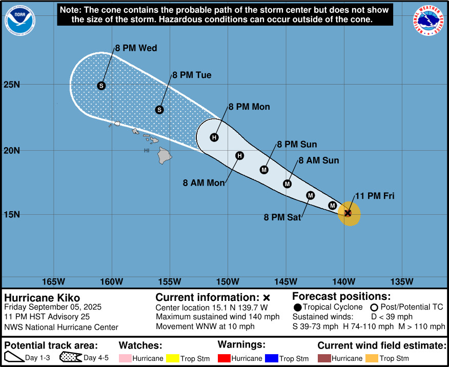
UPDATE – (11 p.m.) – Kiko remains a category 4 hurricane, churning over the Eastern Pacific with 140 mph winds, less than 1,065 miles east southeast of Hilo.
The National Hurricane Center reports Kiko is moving toward the west-northwest near 10 mph. The hurricane is expected to weaken starting on Sunday, and approach the Hawaiian Islands during the early to the middle portion of next week.
FIRST REPORT
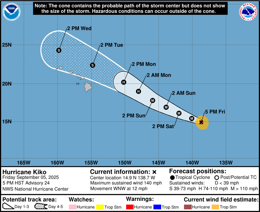
(BIVN) – Hurricane Kiko is less than 1,130 miles east southeast of Hilo, and is now moving toward the west-northwest near 12 mph.
The latest forecast track from the National Hurricane Center still has Kiko weakening to tropical storm strength by Tuesday as it passes north and east of the Hawaiian island chain. For now, Kiko remains a category 4 hurricane on the Saffir-Simpson Hurricane Wind Scale, having restrengthened on Friday. Maximum sustained winds are near 140 mph (220 km/h) with higher gusts, and additional strengthening is possible overnight and into Saturday before gradual weakening begins by Sunday.
Although impacts from rain and wind remain a possibility, the National Weather Service in Honolulu says the main impacts “look to be focused on the marine-side of things”. In a Friday afternoon discussion, the NWS wrote:
Surf along east facing shores will steadily rise Sunday through early next week as swell energy from Tropical Cyclone Kiko arrives. The surf may approach High Surf Advisory Criteria as early as Monday and possibly breach High Surf Warning levels Monday night into Tuesday. However, surf heights will be highly depended on the track and intensity of Kiko as it nears the state.
A state of emergency has been declared across the entire state of Hawai‘i due to the approach of Hurricane Kiko. Acting Governor Sylvia Luke issued the emergency proclamation at 1:10 p.m. Friday afternoon. State officials say the disaster emergency relief period will commence immediately and continue through Friday, September 19th, unless extended or terminated earlier.
From the National Hurricane Center discussion posted at 5 p.m. HST:
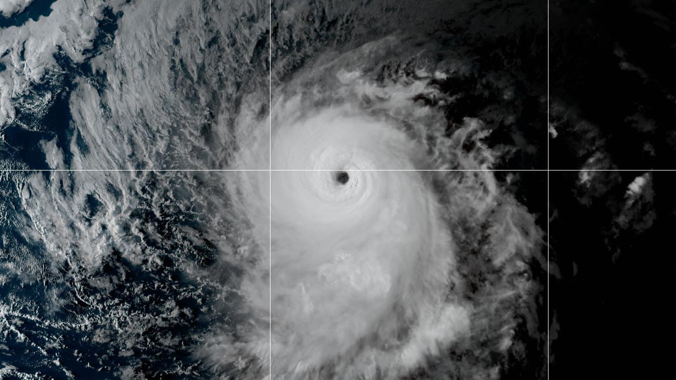
Kiko has continued to intensify this afternoon and remains a category 4 hurricane on the Saffir-Simpson Hurricane Wind Scale. The eye is now surrounded by a large ring of very cold cloud tops, and the cyclone has taken on a structure more typical of annular hurricanes. A GMI microwave pass from 2224 UTC confirmed a symmetric inner-core with a complete ring of deep convection around the eye. The latest objective estimates from UW-CIMSS are as high as 122 kt. Subjective Dvorak classifications from SAB and TAFB are both T6.0/115 kt. Blending the higher objective estimates with the slightly lower subjective classifications yields an initial intensity of 120 kt.
Kiko is moving west-northwestward, or 290 degrees at 10 kt. The cyclone remains steered along the southwestern flank of a subtropical ridge, while an upper-level low north of Hawaii is helping to erode the western periphery of the ridge. This general motion with some increase in forward speed should persist through the weekend, with Kiko expected to cross into the central Pacific basin late tonight or early Saturday. The official forecast track is near the HCCA consensus and essentially unchanged from the previous advisory. However, a track slightly to the left of the official forecast would bring Kiko closer to the Big Island. Historically, cyclones approaching the Big Island from the east can slow and deflect northward as the island terrain disrupts the low-level flow and alters the steering currents.
Kiko should remain a powerful hurricane for the next 12–24 hours while traversing 26–27 C waters with light north-northeasterly shear. Its annular structure may allow it to resist weakening longer than typical guidance, despite the surrounding dry environment in the mid- to upper levels. Beyond 48 hours, a combination of cooler waters, dry mid-level air, and strengthening west-southwesterly shear exceeding 30 kt will likely induce rapid weakening. The official intensity forecast holds Kiko above most of the available guidance into the weekend, then trends more toward the consensus aids later in the weekend and early next week.
Key Messages:
1. Kiko is forecast to approach the Hawaiian Islands during the early to the middle portion of next week. Impacts from rain and wind remain a possibility, but it is too soon to determine the exact location or magnitude of these impacts, and interests there should continue to monitor the progress of this storm.
2. Swells generated by Kiko are expected to begin reaching the Big Island and Maui by Sunday. These swells will gradually build and are forecast to peak along east facing exposures of the Hawaiian Islands late Monday through midweek, potentially producing life-threatening surf and rip currents. Listen for later advisories and possible warnings from the National Weather Service.

by Big Island Video News
on at
STORY SUMMARY
HAWAIʻI - Hurricane Kiko continues to intensify as it remains on track to approach the Hawaiian islands early next week.