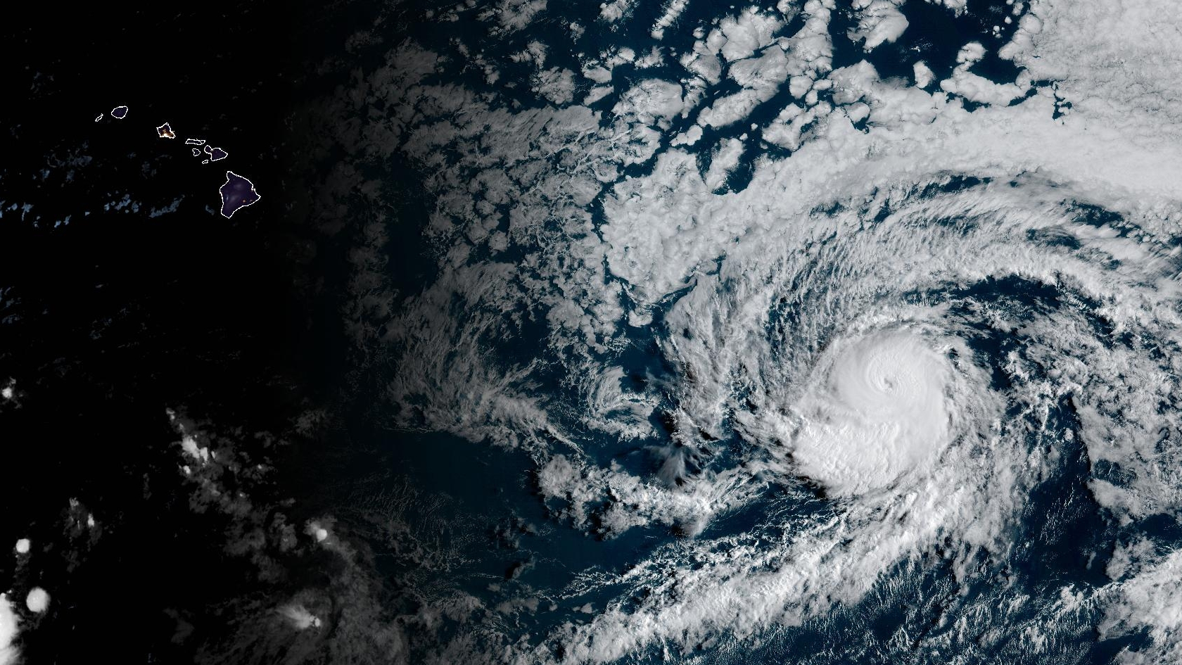
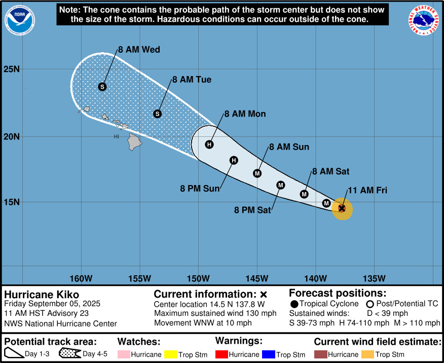
UPDATE – (1:45 p.m.) – Hurricane Kiko quickly re-intensified into a Category 4 hurricane on Friday, with increased maximum sustained winds near 130 mph (215 km/h) with higher gusts.
As of 11 a.m. HST, Kiko was 1,195 miles east southeast of Hilo, moving toward the west-northwest near 10 mph. Kiko is expected to move into the central Pacific basin by Saturday morning.
FIRST REPORT
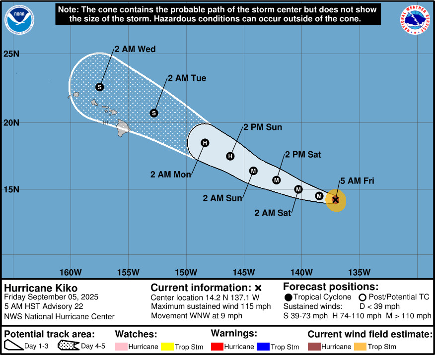
(BIVN) – Hurricane Kiko is less than 1,245 miles east southeast of Hilo, and is now moving toward the west-northwest near 9 mph.
Kiko is still a category 3 hurricane on the Saffir-Simpson Hurricane Wind Scale, although its maximum sustained winds have decreased to near 115 mph. Fluctuations in intensity are expected during the next two days, followed by weakening by early next week as Kiko nears Hawaiʻi.
The official forecast track shows Kiko passing just north of the Hawaiian Islands as a tropical storm Monday through Wednesday.
“The track of Kiko will be determined by the drier Central Pacific environment it will be moving into the next couple of days as well as its interaction with increasing southwesterly shear” from a trough north of Hawaiʻi, the National Weather Service in Honolulu reported on Friday.
“Due to the uncertainly of Kiko’s intensity and track as it interacts with the upper low early next week, the messaging for the state is still centered on the potential for greater areal rain or more frequent shower behavior from Monday through early Thursday,” the Honolulu forecasters said. “Interests in the Hawaiian Islands and surrounding waters need to closely monitor Kiko’s official forecasts from the National Hurricane Center.”
Swells generated by Hurricane Kiko could begin reaching the Hawaiian Islands towards the end of this weekend.
From the National Hurricane Center discussion posted at 5 a.m. HST:
The satellite presentation of Kiko continues to slowly deteriorate early this morning, with the eye obscured by high clouds emanating from the coldest convective tops in the southeast quadrant. The most recent subjective Dvorak current intensity estimates from TAFB and SAB are T6.0/115 kt and T5.0/90 kt. Objective estimates, including ADT from UW-CIMSS, are a bit on the lower end of the spread between 90-100 knots. The intensity has been set at 100 kts as a blend of the subjective and objective intensity estimates.
Kiko has made the expected turn to the west-northwest, or 285 degrees, at 8 kt. The western extent of a subtropical ridge to the north of the cyclone is eroding by a developing upper-level low north of Hawaii. This general west-northwestward motion along with a gradual increase in forward speed is forecast into early next week, as Kiko moves along the southwest periphery of this subtropical ridge towards the upper-level low to the north and northwest of the Hawaiian Islands. The latest track forecast early on is very similar to the previous forecast, before being adjusted somewhat to the north from Monday onward as increasing southwesterly vertical wind shear leads to convective asymmetry which could induce a jog to the right. The track forecast is closest to the HCCA consensus.
Kiko will remain over warm waters of 27–28C for the next 18 hours, while influenced by light northeasterly vertical wind shear, although the cyclone will remain in a drier than optimal mid-level environment keeping the storm size smaller than average. Despite the dry mid-level airmass Kiko will be moving through, the other factors still appear favorable for some slight intensification, so the latest intensity forecast still shows a little short-term strengthening. This forecast also fits in with the possibility for Kiko to develop annular characteristics which could keep it stronger than the forecast intensity guidance. Thereafter, Kiko will move over slightly cooler waters and an even drier mid-level environment. These less favorable conditions should begin a gradual weakening trend, in spite of the very light vertical wind shear. Waters below 26 C await Kiko’s track after Monday, with west-southwesterly vertical wind shear increasing steadily to more than 30 kt by Wednesday, making it more likely the nearby dry air gets imported into Kiko’s small core. The increasingly hostile environment should lead to rapid weakening of the tropical cyclone as it approaches the Hawaiian Islands from the east-southeast. The official intensity forecast has been lowered slightly from the previous advisory cycle, but remains on the higher end of the intensity aids through 48 hours. The intensity forecast then trends closer to the middle of the intensity consensus envelope by Monday, and then trends lower as Kiko should convectively sputter while moving very close to the eastern end of the Hawaiian Island chain as a weakening tropical storm.
Key Messages:
1. Kiko is forecast to approach the Hawaiian Islands during the early to the middle portion of next week. Impacts from rain and wind remain a possibility, but it is too soon to determine the exact location or magnitude of these impacts, and interests there should continue to monitor the progress of this storm.

by Big Island Video News
on at
STORY SUMMARY
HAWAIʻI - Kiko is forecast to approach the Hawaiian Islands as a weakening tropical storm during the early to the middle portion of next week.