(BIVN) – Hurricane Kiko is slowly weakening as it tracks to the north of the Hawaiian Islands.
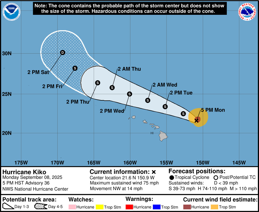
As of 5 p.m. Monday evening, Kiko was a weak category 1 hurricane, 300 miles east-northeast of Hilo. With maximum sustained winds near 75 mph, Kiko is expected to be downgraded to a tropical storm Monday night.
Kiko is forecast to pass north of the Hawaiian Islands on Tuesday and Wednesday, with National Hurricane Center track guidance said to be in good agreement.
The National Weather Service in Honolulu said that “while no direct impacts are expected, a moist and humid airmass with dew points in the low to mid 70s will bring a chance of heavy showers. Although there appears to be no organized moisture over the state on Tuesday, precipitable water within the tropical air mass will be around 1.50 to 1.75 inches, and a weak upper-level trough over the region will help to erode or eliminate the inversion.”
“As Kiko moves to the north of island chain, trade winds will be weakened or disrupted completely, allowing afternoon sea breezes to produce clouds and spotty showers over land,” the Honolulu-based forecasters said. “Some showers may become locally heavy, and we cannot rule out a brief thunderstorm, mainly over interior Big Island. As Kiko passes north of Kauai on Wednesday, moderate trade winds will build over the Big Island and Maui in the afternoon. Heavy showers will still be possible, especially over the western half of the island chain.”
The primary impacts are likely to be from the “dangerously large breaking waves of 10 to 15 feet” that are expected along east-facing shores. A High Surf Warning has been issued.
From the National Hurricane Center discussion posted at 5 p.m. HST:
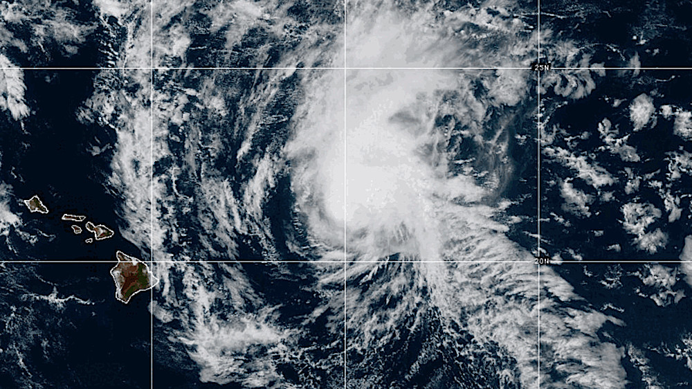
Air Force Reserve Hurricane Hunter aircraft investigating Kiko this afternoon measured maximum flight-level winds of 84 kt at 700 mb and a minimum central pressure of 994 mb. These data, along with subjective Dvorak Current Intensity estimates of 3.5/55 kt from SAB, HFO, and JTWC, and objective estimates from UW-CIMSS ranging from 35 to 54 kt, indicate that Kiko has weakened further. Satellite imagery shows the low-level center becoming increasingly exposed, with deep convection sheared off to the north and northeast and little or no convection remaining in the southern semicircle. Based on a blend of the aircraft and satellite estimates, and accounting for the continued weakening trend since the last fixes, the initial intensity is set at a possibly generous 65 kt, keeping Kiko a Category 1 hurricane for now. Another aircraft mission is scheduled for later this evening and should provide additional confirmation of Kiko’s intensity.
The initial motion remains northwestward, or 305/12 kt, with Kiko continuing to be steered around the southwestern periphery of a subtropical ridge. This motion should persist through the next 12–24 hours, after which Kiko’s increasingly shallow circulation will become more influenced by the low- to mid-level ridge to the north. This evolution is expected to result in a gradual but continued west-northwestward to northwestward trajectory as the cyclone passes north of the Hawaiian Islands on Tuesday and Wednesday. The track guidance remains in good agreement, and the latest NHC forecast is again very close to the previous one, staying near a blend of the multi-model consensus aids and the Google DeepMind ensemble mean (GDMI).
The southwesterly vertical wind shear affecting Kiko has increased beyond earlier predictions, now estimated at 35–40 kt, and this has accelerated the weakening trend. This elevated shear is forecast to persist through Tuesday, maintaining a highly unfavorable environment for Kiko. As a result, Kiko will likely be downgraded to a tropical storm later this evening or overnight as additional reconnaissance data become available. Beyond 48 hours, SHIPS guidance still indicates a brief decrease in shear while sea surface temperatures rise slightly to near 27 C, which could slow the weakening rate somewhat. The new NHC intensity forecast remains close to the middle of the guidance envelope, showing Kiko becoming a tropical storm within the next 12 hours and continuing to gradually weaken thereafter.
Key Messages:
1. Kiko is forecast to pass north of the Hawaiian Islands on Tuesday and Wednesday. While the risk of direct impacts on the islands continues to decrease, interests should continue to monitor Kiko’s progress and the latest forecasts.
2. Swells generated by Kiko are gradually building from east to west across the exposed Hawaiian waters and are forecast to peak tonight through Wednesday, potentially producing life-threatening surf and rip currents. Refer to the latest updates and forecasts issued from the National Weather Service in Honolulu, Hawaii.

by Big Island Video News
on at
STORY SUMMARY
ISLAND OF HAWAIʻI - Kiko has steadily weakened to the east-northeast of Hilo, but remained a category 1 hurricane as of Monday evening.