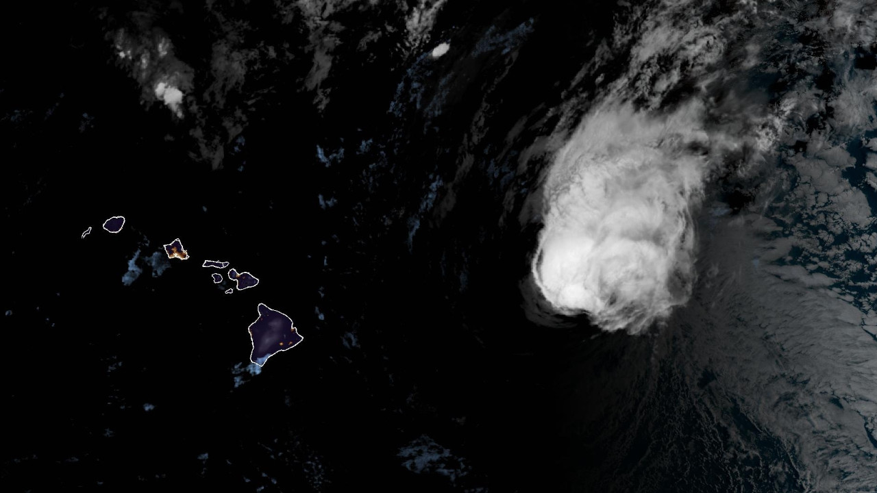
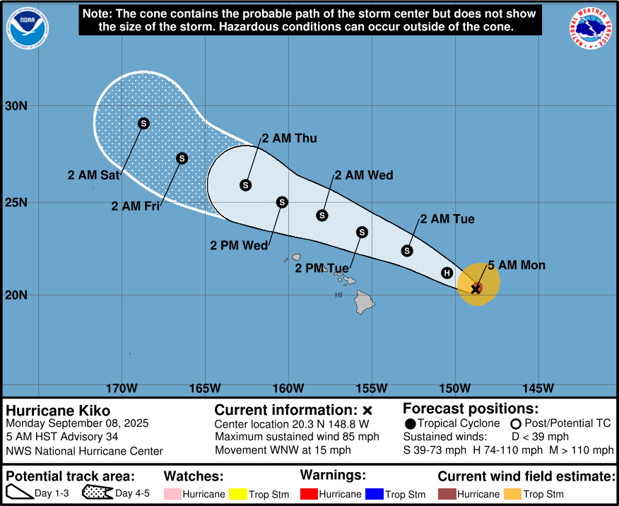
(BIVN) – Hurricane Kiko was located about 410 miles east of Hilo as of 5 a.m. Monday morning, moving west northwest at 15 mph.
Kiko is now a category 1 hurricane. Maximum sustained winds have decreased to near 85 mph. Kiko is expected to become a tropical storm by the end of the day, passing north of the Hawaiian Islands Tuesday and Wednesday.
“Confidence in this scenario is increasing, though interests in Hawaii should continue to monitor official forecasts for Kiko,” the National Weather Service in Honolulu stated, “Moisture along the periphery of the system will spread over the state Monday night and Tuesday. Initially, this will provide an increase in clouds and mainly windward showers, but as trade winds become disrupted, afternoon sea breezes will likely trigger spotty interior rainfall. These showers could be locally heavy in places, and we cannot rule out a brief thunderstorm as the atmosphere destabilizes on Tuesday. As dew points creep into the low to mid 70s, rather humid conditions will prevail.”
Large surf is expected to arrive along east facing shores soon.
“Latest buoy observations from buoy 51004 has started to pick up energy in the 11 to 13 second spectral bands throughout the night,” the National Weather Service said. “Surf will likely come in below advisory thresholds through today. But, as Kiko moves northwest, a rapid rise of a short lived east swell is expected to fill in, peak potentially at low end High Surf Warning levels Tuesday, before declining through Wednesday. A High Surf Warning for east facing shores will likely be issued this afternoon. Note, peak surf heights will be highly dependent on the track and intensity of Kiko as it nears the state.”
From the National Hurricane Center discussion posted at 5 a.m. HST:
Before departing, the final Air Force Reserve Hurricane Hunter aircraft fix into Kiko showed that the hurricane’s structure continues to degrade, with the dropsonde launched at 1104 UTC showing increasing tilt with height between the surface center and flight level center. Maximum flight level winds from earlier in the mission were still 94 kt at 700 mb, but the structure has degraded further since that time. In fact satellite-based intensity estimates are much lower, and only support an intensity of 55 to 75 kt. The initial intensity of Kiko this advisory is being lowered to 75 kt, on the higher end of the satellite estimates, in deference to the earlier recon data.
Kiko continues to move west-northwestward, with its estimated motion at 300/13 kt. For the next 12-24 hours this motion should continue as Kiko remains vertically deep, and is steered along the southwestern periphery of a subtropical ridge. However, the hurricane is quickly approaching a large deep-layer trough, which is imparting significant southwesterly mid- to upper-level flow. At this juncture, this flow is expected to significantly shear the cyclone, making it more vertically shallow, and it will become increasingly steered by the mid- to low-level flow which still has an anticyclone to its north. Thus, the west-northwestward motion is expected to continue beyond 24 hours too, and may even turn slightly leftward in days 3-4. The track guidance remains is good agreement on this scenario, and the latest NHC track forecast is very close to the prior one, blending the reliable consensus aids HCCA and TVCE with the Google Deep-Mind ensemble mean (GDMI). On the forecast track, Kiko is expected to pass north of the Hawaiian islands later this week and at this time no tropical storm watches are necessary for the island chain.
The hurricane now appears to be feeling the effects of southwesterly vertical wind shear, which is now above 25 kt and expected to increase further over the next 24 hours. In addition, very dry air as seen on GOES-18 water vapor imagery is located in that upshear direction, and will likely be imported into Kiko’s small inner core. Thus, weakening is anticipated to continue, and Kiko will likely weaken below hurricane intensity even as the cyclone starts to move over warmer sea-surface temperatures in 24-48 hours. There is a brief period where the shear weakens in 2-3 days before it increases again out of the east. Given the latest guidance, it seems more likely Kiko’s structure will not allow the cyclone to recover much, and slow weakening is still forecasted through the end of the forecast period. The latest NHC intensity forecast is close to the middle of the guidance envelope through the 5 day period.
Key Messages:
1. Kiko is forecast to pass north of the Hawaiian Islands on Tuesday and Wednesday. While the risk of direct impacts on the islands continues to decrease, interests there should continue to monitor Kiko’s progress and the latest forecast.
2. Swells generated by Kiko are expected to gradually build and are forecast to peak along east-facing exposures of the Hawaiian Islands late today through the middle of the week, potentially producing life-threatening surf and rip currents. Listen to the latest updates and potential High Surf Warnings issued from the National Weather Service in Honolulu, Hawaii.

by Big Island Video News
on at
STORY SUMMARY
HAWAIʻI - Hurricane Kiko is still expected to pass north of the Hawaiian Islands this week, bringing high surf and rip currents to eastern shores.