(BIVN) – A tsunami evacuation drill will be held in the Keaukaha-area of Hilo on Friday, November 21st.
During Friday’s exercise, motorists will not make their mock-escape using the Hilo International Airport runway. The perimeter gates will remain shut. Instead, the County of Hawaiʻi will open the Leleiwi Evacuation Route from 9 a.m. to 11 a.m., “so residents can practice driving the route”, officials say.
“Time is of the essence when a tsunami threatens Hawai‘i Island, so we encourage everyone living, working or learning in coastal areas to know and practice their escape routes,” said Mayor Kimo Alameda in a news release.
The news release included a map of showing the Leleiwi Evacuation Route.
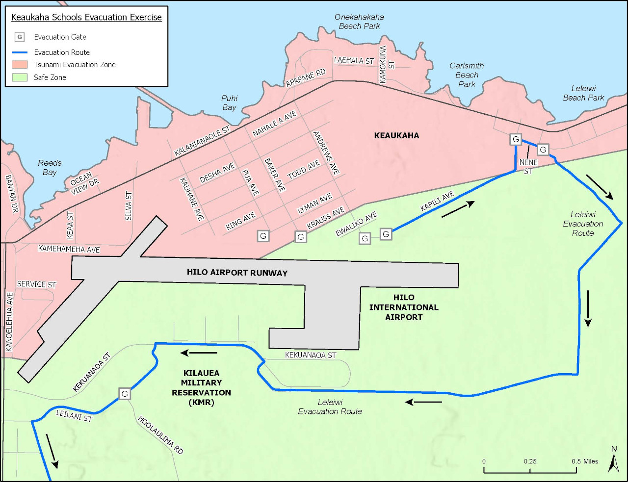
map showing the Leleiwi Evacuation Route courtesy the County of Hawaiʻi
Several Keaukaha-area schools will also be participating in the Friday drill. They are:
- Keaukaha Elementary School
- Kamehameha Schools Preschool – Keaukaha
- Ke Ana La’ahana Public Charter School
- Ka ʻUmeke Kāʻeo Public Charter School – Kai Koholā
- Ka ʻUmeke Kāʻeo Public Charter School – Pa Hoaka
Students from the participating schools will follow their prepared evacuation plans as far as the airport gates at Andrews, Baker and Pua avenues.
From a County news release:
During evacuations for the July 29 tsunami warning, residents of the area used gates at the airport perimeter to cross the runway. For this exercise, the perimeter gates will remain shut and people will not enter the airport grounds.
For the Leleiwi Evacuation Route practice, County personnel will open the gates along Nene Street to allow residents to drive on and familiarize themselves with the evacuation route, which takes them away from the shore.
County personnel also will open the gates to access Kapili Avenue to allow Keaukaha residents to access the evacuation route.
Officials from Hawai‘i County Civil Defense Agency have held a series of community meetings to share information about the evacuation routes and address concerns to improve public safety in the residential and commercial areas around the Hilo airport.
The Nov. 21 exercise is a key piece of that public safety effort, said Talmadge Magno, Civil Defense Administrator.
“Hilo has seen tragic damage and loss of life from tsunamis over the years,” Magno said. “The best way to stay safe is to move out of the inundation zone when a tsunami threatens, and learning these evacuation routes helps to make that possible.”

by Big Island Video News
on at
STORY SUMMARY
HILO, Hawaiʻi - Schools and residents in Keaukaha will take part in the evacuation exercise set for Friday, November 21.