(BIVN) – Mauna Loa volcano on Hawaiʻi island is not erupting, and its current USGS Volcano Alert Level is at NORMAL.
Earlier this month, the USGS Hawaiian Volcano Observatory reported seismic activity at Mauna Loa increased slightly, with a tight clustering of events under Mokuʻāweoweo at the summit and upper Southwest Rift Zone. Instruments detected “variable rates of inflation at the summit over the past six months,” the HVO stated. “This is associated with refilling of the summit reservoir system following the 2022 eruption, as well as recent refilling of a magma chamber under the southern caldera region.”
In the latest Volcano Watch article, HVO research geophysicist Ingrid Johanson writes more about the recent patterns of inflation at Mauna Loa:
The 2022 eruption of Mauna Loa was an extraordinary eruption in a lot of ways. It was the first eruption from this volcano in 38 years and the first Mauna Loa eruption that occurred during the current era of modern instrumentation. Scientists continue to learn about Mauna Loa monitoring in the years since the 2022 eruption, including subtle recent changes.
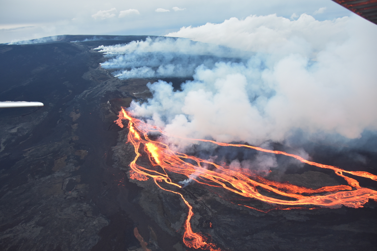
USGS: “Aerial photo captured during an overflight of the Northeast Rift Zone eruption of Mauna Loa at approximately 5-6:30 p.m. HST on November 28, 2022. This photo is looking at the line of fissure vents erupting above 10,000 ft elevation on the Northeast Rift Zone of Mauna Loa.” (Image courtesy of Civil Air Patrol)
The long-term buildup to the 2022 eruption began in 2014, with an increase in seismicity and deformation as measured by the USGS Hawaiian Volcano Observatory’s (HVO) network of GPS stations. These indictors fluctuated until 2019, when they began to increase again. In 2021, we observed changes on a Mauna Loa tiltmeter representing the first time a volcanic signal had been recorded on that instrument. As explained in a “Volcano Watch” article on May 6, 2021, tiltmeters are particularly sensitive to shallow magma movement. This was evidence that magma had reached a shallow depth in 2021 and was an important indicator that the buildup to eruption was evolving.
The 2022 eruption began just before midnight on November 27, preceded by an hour‑long earthquake swarm and rapid summit inflation. It started in the summit region before moving into Mauna Loa’s Northeast Rift Zone. There, multiple fissures produced lava flows that erupted downslope towards the Daniel K. Inouye Highway. During the eruption, seismicity quieted down and deformation indicated rapid deflation of Mauna Loa’s magma chambers. By December 13, 2022, the lava flows had slowed and the eruption had stopped.
Following the end of the eruption, GPS instruments quickly began to show inflationary motion again, presumably as magma rose from deeper in the volcano into the magma chambers that had been depleted during the eruption. This rapid refilling continued for about six months before settling into a steadier reinflation pattern.
Recently, changes to the reinflation pattern have given us some clues to the current state of the volcano. In November 2025, the deformation pattern around Mauna Loa’s summit changed. Where previous motions indicated reinflation of magma chamber underneath Moku’āweoweo (summit caldera), inflation shifted to a body underneath the southwestern portion of the summit region.
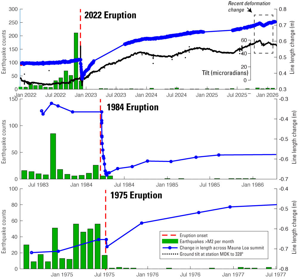
USGS: “Graphs of ground deformation and earthquake data spanning three eruptions at Mauna Loa. Top panel spans the 2022 eruption, middle is for the 1984 eruption, and the bottom panel spans the 1975 eruption. Green bars show the number of earthquakes with magnitude greater than 2 during each month; in all cases earthquake rate drop off significantly following an eruption. Blue points and lines are line length changes measured by Electronic Distance Meters (EDM) during 1975 and 1984 and by GPS in 2022, between two stations spanning Mokuʻāweoweo, the summit caldera. An estimate of the line length changes due to the opening fissures has been removed from all three timeseries. Black points in the top panel are ground tilt measurements from a tiltmeter at the summit of Mauna Loa, installed in 1999. Yearly variations in tilt (gentle oscillations) are seasonal noise. Following all three eruptions, rapid lengthening of the line across the summit indicated refilling (inflation) of the shallow magma chamber without significant seismicity in the first 1-2 years after an eruption.”
This was not the first time this pattern had been observed. In 2015, the deformation pattern seen with GPS shifted in a similar way. Inflation of the southwestern magma chamber continued until late 2016, before switching back to the more central body under Moku’āweoweo. This time, deformation switched back much faster; by December 15, 2025, the inflation center was again under the summit caldera.
Interestingly, the 2025 deformation changes seen with GPS were also accompanied by clear changes in tilt at a summit tiltmeter. This was not the case in 2015, when only GPS stations recorded volcanic deformation. The fact that this deformation is detectable on tiltmeters is an indication that magma is still fairly shallow in the volcano (geologically speaking), possibly between 2-3 km below the surface (1.25–1.8 miles).
However, currently there is less seismicity at Mauna Loa than at almost any time during the eight years of unrest before the 2022 eruption. This means that the deformation we’re seeing is likely passive refilling in the volcano that isn’t stressing the crust in a way that would indicate the volcano is moving towards eruption.
This pattern was observed following the 1975 and 1984 Mauna Loa eruptions as well. Rapid inflationary deformation was recorded without much seismicity. It wasn’t until earthquakes started again that the volcano clearly began moving toward its next eruption.
The tilt and GPS observations are nonetheless a reminder that Mauna Loa is in a different state now than it was before the 2022 eruption. The tilt changes provide evidence that magma is still mobile in Mauna Loa, which is an important factor in how unrest might progress in the future. The build up to the next eruption might not look the same as the buildup to 2022. Especially if Mauna Loa returns to producing eruptions more frequently than decades apart, as it did prior to 1984.
The alert level for Mauna Loa is currently “normal”; we expect to see additional changes such as increased seismicity or gas emissions before any future eruption. Even during quiet times, keeping a close eye on the volcanoes can teach important lessons that will inform our interpretations and decisions as the conditions change.

by Big Island Video News
on at
STORY SUMMARY
ISLAND OF HAWAIʻI - Geologists with the USGS Hawaiian Volcano Observatory say Mauna Loa has lessons to teach, even during quiet times.