HILO, Hawaii – Tropical Storm Flossie is less than 1,155 miles from Hilo and it is picking up steam. The National Weather Service reports…
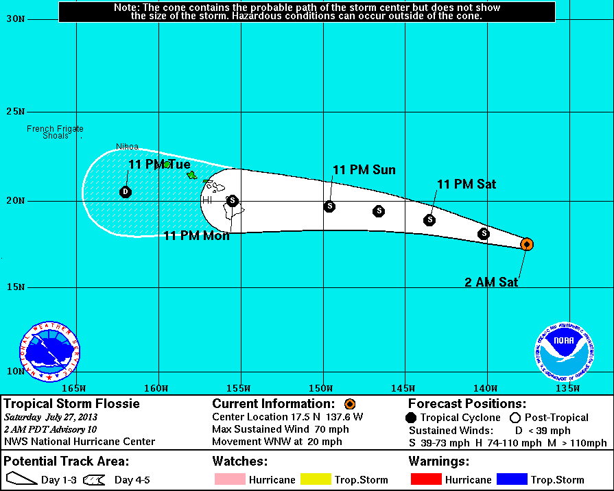
Courtesy National Weather Service: This graphic shows an approximate representation of coastal areas under a hurricane warning (red), hurricane watch (pink), tropical storm warning (blue) and tropical storm watch (yellow). The orange circle indicates the current position of the center of the tropical cyclone. The black line, when selected, and dots show the National Hurricane Center (NHC) forecast track of the center at the times indicated. The dot indicating the forecast center location will be black if the cyclone is forecast to be tropical and will be white with a black outline if the cyclone is forecast to be extratropical. If only an L is displayed, then the system is forecast to be a remnant low. The letter inside the dot indicates the NHC’s forecast intensity for that time: D: Tropical Depression – wind speed less than 39 MPH S: Tropical Storm – wind speed between 39 MPH and 73 MPH H: Hurricane – wind speed between 74 MPH and 110 MPH M: Major Hurricane – wind speed greater than 110 MPH
HILO, Hawaii – Tropical Storm Flossie is less than 1,155 miles from Hilo and it is picking up steam.
The National Weather Service reports the storm has strengthened since the last report was issued. Now, maximum sustained winds are being measured at 70 miles per hour. Flossie would have to reach 74 mph winds in order to become classified as a hurricane. But the NWS does not foresee the storm gaining more power as it begins to move over cooler waters and drier air, which should weaken the storm.
From the most recent NWS discussion on the storm:
National Weather Service
“Flossie has strengthened during the last several hours. Microwave images showed the development of a mid-level eye a little before 0600 UTC… And glimpses of that feature have become apparent in recent geostationary satellite images. Dvorak classifications have increased to 3.5/55 kt…But given the improvement in organization since then…The initial wind speed is set at 60 kt. Flossie has crossed the 26c isotherm and is headed for slightly cooler waters during the next day or two. These cooler waters and drier air should cause the cyclone to hold steady in strength or begin to weaken. Even though the water temperatures increase along the expected track of Flossie beginning in about 48 hours…Westerly shear and a drier airmass should result in additional weakening. The NHC wind speed forecast is in good agreement with the intensity model consensus and is slightly higher than the previous forecast in the short term.
The tropical storm remains on a steady west-northwestward path at about 17 kt. This motion is expected to continue for about another day…Followed by a slight decrease in forward speed and a turn toward the west. The models are in fairly good agreement…And little change was made to the previous NHC track forecast. Flossie is expected to be near or over the Hawaiian islands in about 3 days.
Based on the current forecast…Flossie will enter the central pacific hurricane center area of responsibility around 1800 utc.
Under the scenario described above by the weather service, Flossie would be a weak tropical storm by the time it reaches Hawaii Island.
Although there are presently no coastal watches or warnings in effect, the National Weather Service advises that, “Interests in the Hawaiian Islands should monitor Flossie through the weekend.”
About The Featured Image
Courtesy National Weather Service: This graphic shows an approximate representation of coastal areas under a hurricane warning (red), hurricane watch (pink), tropical storm warning (blue) and tropical storm watch (yellow). The orange circle indicates the current position of the center of the tropical cyclone. The black line, when selected, and dots show the National Hurricane Center (NHC) forecast track of the center at the times indicated. The dot indicating the forecast center location will be black if the cyclone is forecast to be tropical and will be white with a black outline if the cyclone is forecast to be extratropical. If only an L is displayed, then the system is forecast to be a remnant low. The letter inside the dot indicates the NHC's forecast intensity for that time:
D: Tropical Depression – wind speed less than 39 MPH
S: Tropical Storm – wind speed between 39 MPH and 73 MPH
H: Hurricane – wind speed between 74 MPH and 110 MPH
M: Major Hurricane – wind speed greater than 110 MPH
Big Island Video News has been serving Hawaiʻi island since 2008.
 National Weather Service