Big Island Video News

Serving Hawaii County

  • Hawaiʻi Island News Regions
    • Hamakua
      • Mauna Kea
    • Hilo
    • Kau
    • Kona
    • Kohala
    • Puna
Lava Information Message Issued by Hawaii County Civil Defense
Avatar photo

by Big Island Video News
on Aug 28, 2014 at 1:12 pm

Subscribe to Big Island Video News (FREE)

* indicates required

STORY SUMMARY

Presently, the flow does not present with an immediate or imminent threat to area communities.

https://www.bigislandvideonews.com/wp-content/uploads/2014/08/eruption-update-8-28-14-1230pm.mp3

ABOVE: Hawaii County Civil Defense message – Lava Update for Aug. 28, 2014

PUNA, Hawaii – Hawaii County Civil Defense has issued the first audio message in regards to the June 27 lava flow on Hawaii Island. Recorded shortly after noon on Thursday, the “Eruption Information Update” brings Puna’s concerned population up to speed on the volcanic activity.

Here is the content of the message, which can be heard using the media player above:

Hawaii County Civil Defense

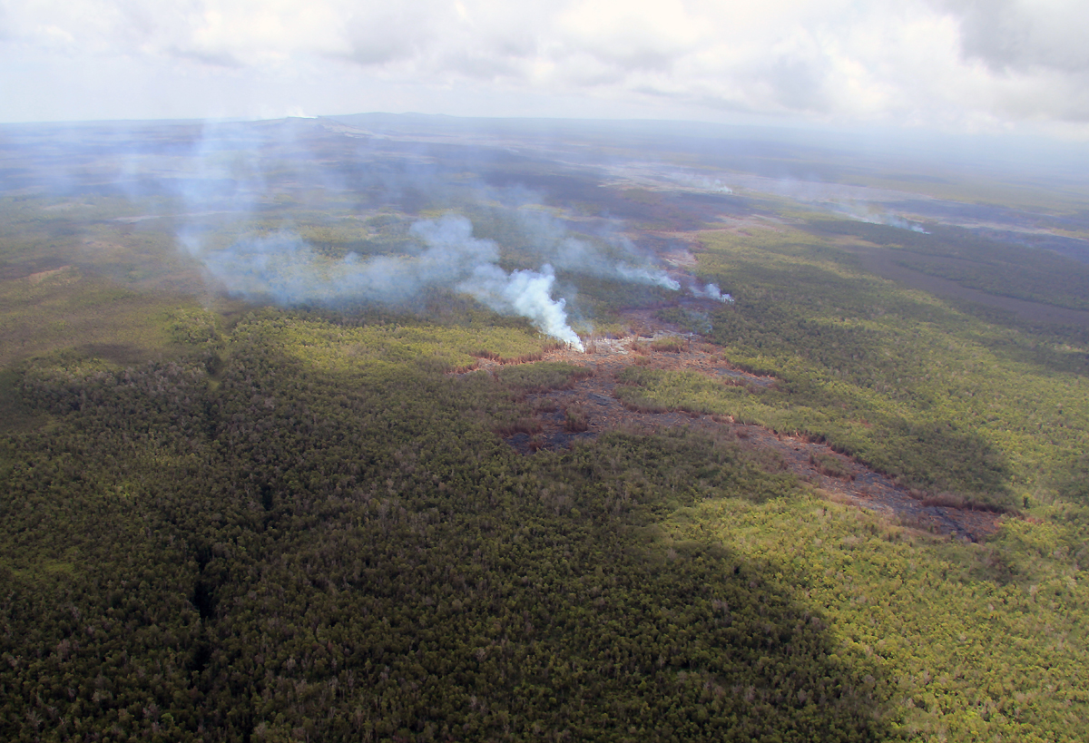
This morning’s helicopter over flight and assessment showed that there is presently no surface activity. The current flow had entered a crack system earlier this week and there is some evidence to indicate subsurface lava activity. The evidence is limited to steam plumes along the area of the crack.

Presently, the current activities and flow does not present with an immediate or imminent threat to area communities.

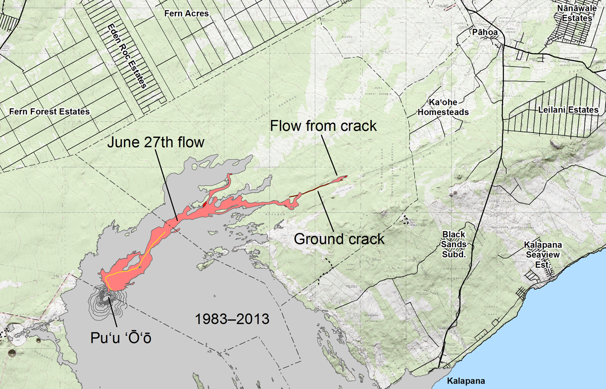
The location of the crack and areas of the steam is approximately 1.7 miles southwest or upslope of the Wao Kele Puna Forest Reserve boundary. Eruption activity will be monitored and additional updates will be provided.

Area residents are encouraged to continue to review their emergency plans in the event conditions change and should an evacuation be necessary. As stated, the current flow activity does not present with an immediate or imminent threat. This update and is to keep area residents informed of current observations.

The public is advised that the flow cannot be accessed and is not visible from any public areas. Please do not attempt to access the area as there are many cracks and dense vegetation. In addition please refrain from attempting to do so through the Kaohe Homesteads subdivision and respect the privacy of area residents. Hawaii County Civil Defense audio message

According to USGS: The area of the flow as mapped on August 25 is shown in pink, while widening and advancement of the flow as of August 27 is shown in red. The brown line marks the ground crack that channeled lava to the east, where it emerged to form a new pad of lava over the past couple of days. The distal tip of this new lava pad is 11.5 km (7.1 miles) east-northeast of Puʻu ʻŌʻō, and 3.0 km (1.9 miles) from the edge of the Wao Kele O Puna Forest Reserve. However, the tip of the flow was inactive today and there was no indication that lava was continuing to advance within ground cracks. The most distant active flows were 8.5 km (5.3 miles) from the vent. All older lava flows (1983–2014) are shown in gray. The thin yellow line marks a portion of the lava tube feeding the flow.

According to USGS: The area of the flow as mapped on August 25 is shown in pink, while widening and advancement of the flow as of August 27 is shown in red. The brown line marks the ground crack that channeled lava to the east, where it emerged to form a new pad of lava over the past couple of days. The distal tip of this new lava pad is 11.5 km (7.1 miles) east-northeast of Puʻu ʻŌʻō, and 3.0 km (1.9 miles) from the edge of the Wao Kele O Puna Forest Reserve. However, the tip of the flow was inactive today and there was no indication that lava was continuing to advance within ground cracks. The most distant active flows were 8.5 km (5.3 miles) from the vent. All older lava flows (1983–2014) are shown in gray. The thin yellow line marks a portion of the lava tube feeding the flow.

The update strikes a similar tone to the USGS Hawaiian Volcano Observatory update issued Thursday morning.

usgs hvo

At mid-day yesterday, no active lava was observed at the distal tip of the June 27th flow, and there was no indication that lava was advancing within ground cracks. This part of the flow, which is an isolated pad of lava that was fed from the contiguous flow field via a deep ground crack, reached 11.5 km east-northeast of the vent (3.0 km from the eastern boundary of the Wao Kele o Puna Forest Reserve) before it apparently stalled. While we are cautiously optimistic that this part of the flow is inactive, we will continue to watch it over the coming days. As of yesterday, the most distant lava was 8.5 km from its vent on Puʻu ʻŌʻō, and other small breakouts were scattered across the flow field closer to Puʻu ʻŌʻō. USGS HVO Kilauea update for August 28, 2014


Filed Under: Uncategorized Tagged With: Hawaii County Civil Defense, Hawaiian Volcano Observatory, Kaohe Homesteads, Kilauea, lava, Puna

LATEST NEWS

Freon Gas Leak Closes Downtown Hilo Sack N Save

Two High-Altitude Balloons To Be Launched On Hawaiʻi Island

Moananuiākea Voyage Will Circumnavigate Pacific Ocean

Fire Destroys Hawaiian Ocean View Estates Home

Shark Warning Signs Taken Down At ʻAnaehoʻomalu Bay

Officer Honored For Catching Two Wanted Felons

About Big Island Video News

  • Privacy Policy

Copyright © 2023 · Dynamik-Gen on Genesis Framework · WordPress · Log in