(ABOVE MAP) Civil Defense Lava Flow Map inset for Saturday, Nov. 29 at 8:30 a.m. HST (smaller scale version below)
NEWS BRIEFS
- The nearest breakout activity is currently 2.7 miles upslope of the Apa’a street area. Civil defense says the activity does not pose an immediate threat to area communities.
PRIMARY SOURCES

This morning’s assessment shows that the up slope breakouts remain active. The active and most down slope breakout is located along the north side or margin of the original flow and moving in a north direction. The nearest breakout activity is currently approximately 2.7 miles upslope of the Apa’a street area. Current activity does not pose an immediate threat to area communities and Civil Defense and Hawaiian Volcano Observatory personnel are maintaining close observations of flow activity. Residents down slope will be kept informed of any changes in flow activity, advancement, and status.
Smoke conditions were moderate to heavy in the immediate area with all smoke from burning vegetation being blown in a southeast direction. Smoke conditions may increase in some areas and residents that may be sensitive or have respiratory problems are advised to take precautions and to remain indoors.
The Pahoa Village Road remains open to all traffic and motorists are advised to exercise caution as some utility pole protection material remains in place. Everyone is asked to please respect the residents of the area who were affected by the lava flow and to not trespass on private property.
Additional updates will be posted as conditions change.
Once again we would like to thank everyone for your patience and understanding and your cooperation and assistance is greatly appreciated.Hawaii County Civil Defense on Nov. 29 at 8:45 a.m.
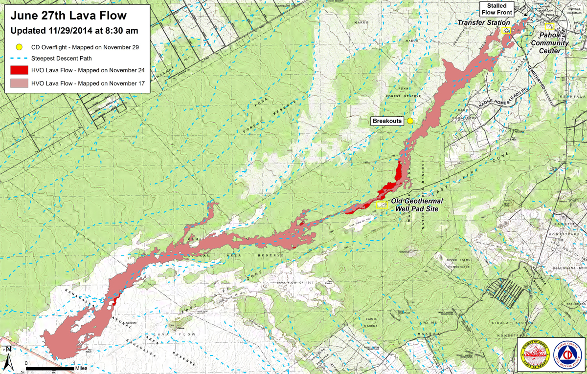
Civil Defense Lava Flow Map for Saturday, Nov. 29 at 8:30 a.m. HST

Kīlauea Volcano continues to erupt at its summit and within its East Rift Zone. Active breakouts are occurring in the upper part of the June 27th flow field around the crack system near the abandoned geothermal well site. There has been no significant ground tilt across the entire volcano over the past 24 hours, and the level of the summit lava lake fluctuated according to changes in spattering.
June 27th Lava Flow Observations: The lowermost breakouts from the crack system near the abandoned geothermal well site remain active. Friday’s scheduled overflight was canceled due to poor weather conditions, but analysis of Webcam imagery indicates that the most downslope lava flows are approximately 5 km (3 mi) above Apaʻa Street. The average advance rate of these breakouts over the pasts several days was about 250 meters/day (275 yards/day). A helicopter overflight is currently planned for Monday, weather permitting.
Puʻu ʻŌʻō Observations: Activity at Puʻu ʻŌʻō continues to follow the trend established over the past few days: there has been no net ground tilt over the past 24 hours, seismic tremor remains low, and webcams revealed no strong variations in the pattern of glow from degassing vents or the configuration of the crater floor. GPS-measured deformation across the cone has shown neither extension nor contraction since July. The most recent measurement of sulfur dioxide emissions from the East Rift Zone was about 250 tonnes per day on November 26, 2014.
Summit Observations: For most of the past 24 hours there was little net ground tilt at Kilauea’s summit, although minor deflation began at around 5 AM and continues as of this writing. The surface height of the lava lake in the Overlook vent fluctuated by several meters, averaging about 55 meters (180 feet) below the floor of Halemaʻumaʻu Crater. Volcanic tremor amplitude similarly varied in concert with spattering activity in the lake. Small amounts of particulate material were carried aloft by the plume. The average emission rate of sulfur dioxide was 6,900 tonnes/day for the week ending on November 25 USGS Hawaiian Volcano Observatory on Nov. 29 at 8:29 a.m. HST

by Big Island Video News
on at
STORY SUMMARY
The nearest breakout activity is currently 2.7 miles upslope of the Apa’a street