Big Island Video News

Serving Hawaii County

  • Hawaiʻi Island News Regions
    • Hamakua
      • Mauna Kea
    • Hilo
    • Kau
    • Kona
    • Kohala
    • Puna
Evening Lava Update – Tuesday, Dec. 9
Avatar photo

by Big Island Video News
on Dec 9, 2014 at 9:53 pm

Subscribe to Big Island Video News (FREE)

* indicates required

STORY SUMMARY

Tonight, the leading edge is 2.1 miles upslope from the intersection of Highway 130 and Pāhoa Village Road at the Pahoa Marketplace.

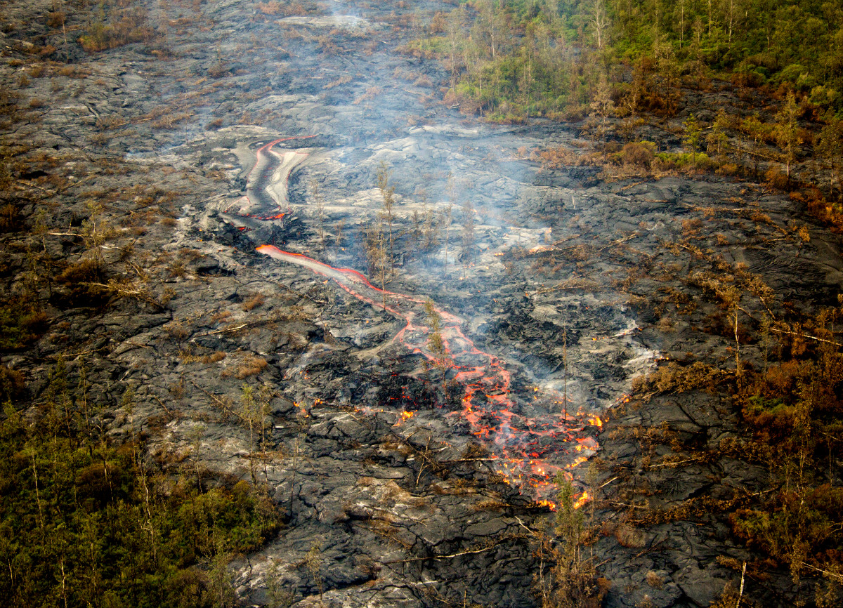
(ABOVE PHOTO) This USGS photo from Dec. 9 shows a vigorous channelized breakout on the flow, a short distance upslope of the leading tip of activity. Maps below.

NEWS BRIEFS

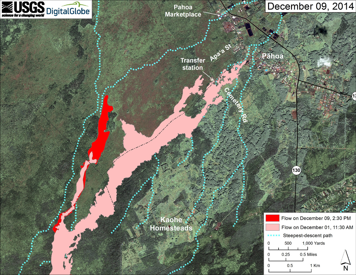
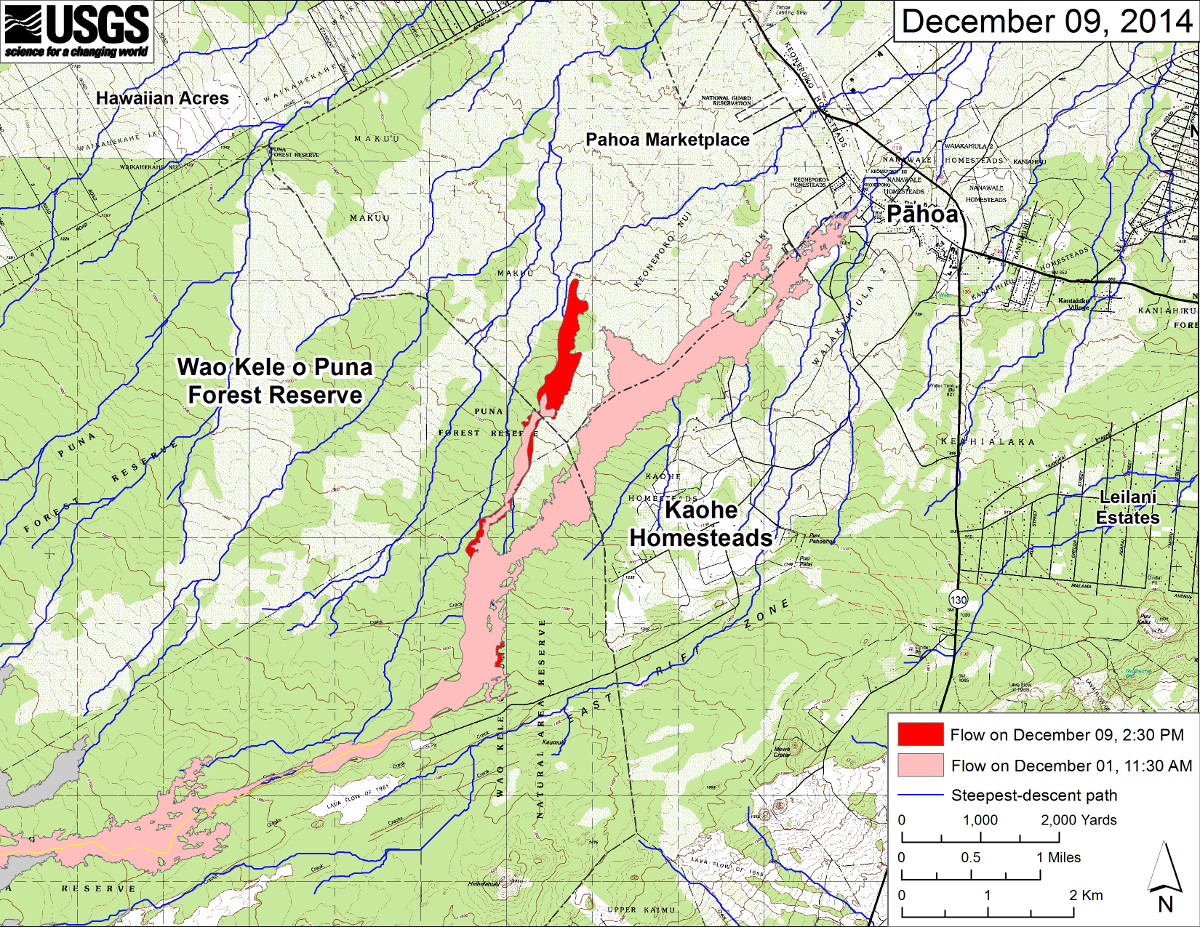
  • During the past 2 days, the lava flow front has advanced about 165 yards per day. Tonight, the leading edge is 2.1 miles upslope from the intersection of Highway 130 and Pāhoa Village Road at the Pahoa Marketplace.
  • USGS Hawaiian Volcano Observatory confirms the flow front is following the steepest-descent path towards the intersection of Pāhoa Village Road and Highway 130, in the vicinity of the Pahoa Marketplace.

PRIMARY SOURCES

usgs hvo

USGS Hawaiian Volcano Observatory (HVO) scientists conducted an overflight this afternoon, mapping and observing the entire length of the active lava flow erupting from Puʻu ʻŌʻō. The active lobe that branched off the west edge of the flow field downslope from the crack system has advanced about 300 m (330 yd) since December 7. During the past 2 days, the average advance rate is 150 m/day (165 yd/day), which is less than half the advance rate of last week.

The leading edge of this lobe was 3.4 km (2.1 mi) upslope from the intersection of Highway 130 and Pāhoa Village Road at the Pahoa Marketplace. Along its length, the width of this lobe varies between about 80 m (90 yd) to 330 m (360 yd). The active lobe is following a steepest-descent path that takes the flow towards the intersection of Pāhoa Village Road and Highway 130, in the vicinity of the Pahoa Marketplace.

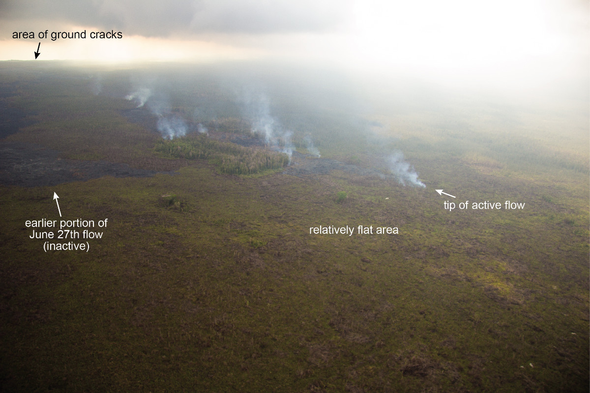
In addition to this active lobe, a breakout from the lava tube on December 5, about 2.6 km (1.6 mi) from Puʻu ʻŌʻō remains weakly active. The breakout is about 1 km (0.6 mi) long, and has widened the flow field in this area by about 200 m (220 yd).

During today’s fieldwork, HVO scientists also measured a slight increase in the cross-sectional area of the lava stream within the tube near Puʻu ʻŌʻō compared to measurements made on December 1.USGS Hawaiian Volcano Observatory on Dec. 9 at 8:49 p.m. HST

This USGS photo shows the flow front is in an area of relatively flat topography, which may explain reduced advance rates over the past few days.

This USGS photo shows the flow front is in an area of relatively flat topography, which may explain reduced advance rates over the past few days.

This USGS map uses a satellite image acquired in March 2014 (provided by Digital Globe) as a base to show the area around the front of Kīlauea’s active East Rift Zone lava flow. The area of the flow on December 1, 2014, at 11:30 AM is shown in pink, while widening and advancement of the flow as mapped on December 9 at 2:30 PM is shown in red.

This USGS map uses a satellite image acquired in March 2014 (provided by Digital Globe) as a base to show the area around the front of Kīlauea’s active East Rift Zone lava flow. The area of the flow on December 1, 2014, at 11:30 AM is shown in pink, while widening and advancement of the flow as mapped on December 9 at 2:30 PM is shown in red.

This USGS large-scale map shows the distal part of Kīlauea’s active East Rift Zone lava flow in relation to nearby Puna communities. The area of the flow on December 1, 2014, at 11:30 AM is shown in pink, while widening and advancement of the flow as mapped on December 9 at 2:30 PM is shown in red.

This USGS large-scale map shows the distal part of Kīlauea’s active East Rift Zone lava flow in relation to nearby Puna communities. The area of the flow on December 1, 2014, at 11:30 AM is shown in pink, while widening and advancement of the flow as mapped on December 9 at 2:30 PM is shown in red.


Filed Under: Uncategorized Tagged With: June 27 lava flow, Pahoa

LATEST NEWS

VOLCANO WATCH: Pele’s Hairs, Beautiful Hazard On Hawaiʻi

New Cutter Boosts Coast Guard Presence In Hawaiʻi

Magnitude 3.9 Quake, Aftershocks Recorded On Mauna Loa

Hawaiʻi Warns: Fake FBI Bitcoin Scam Spoofs AG Phone Number

Five New Ambulances Added To Hawaiʻi County Fleet

Woman Cited For Taking Nēnē Gosling From Hilo Park

About Big Island Video News

  • Privacy Policy

Copyright © 2023 · Dynamik-Gen on Genesis Framework · WordPress · Log in