(ABOVE VIDEO) Audio from today’s media conference call with video from Monday’s overflight by Mick Kalber aboard Paradise Helicopters.
NEWS BRIEFS
- The active tip of the lava flow was about 1.1 miles from the upslope edge of the Pahoa Marketplace along the path of steepest descent that the flow is currently following. It has traveled half a mile in slightly less than 3 days.
- Civil defense has kept close contact with the merchants of Pahoa Marketplace. No evacuation order or advisory has been given, but the merchants are on notice. Some businesses are already initiating their own plans.
- Officials are still working on opening public access on Apaa Street as early as Wednesday or later this week. The Hawaii County Department Public Works is working on shoulder improvements on Apa’a in order to accomodate the expected traffic increase.
PRIMARY SOURCES

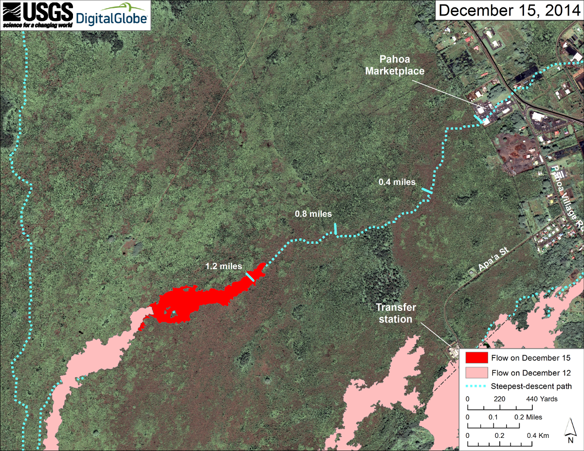
This map uses a satellite image acquired in March 2014 (provided by Digital Globe) as a base to show the area around the front of Kīlauea’s active East Rift Zone lava flow. The area of the flow on December 12, 2014, at 10:00 AM is shown in pink, while advancement of the flow as mapped from satellite imagery collected early this morning is shown in red. This represents an advancement of 0.8 km (~0.5 miles) in slightly less than 3 days.
The active tip of the flow was about 1.8 km (~1.1 miles) from the upslope edge of the Pahoa Marketplace along the path of steepest descent that the flow is currently following. Tick marks have been placed along the steepest-descent path at an interval of 0.4 miles, measured from Pahoa Marketplace.
The blue lines show steepest-descent paths calculated from a 1983 digital elevation model (DEM; for calculation details, see http://pubs.usgs.gov/of/2007/1264/). Steepest-descent path analysis is based on the assumption that the DEM perfectly represents the earth’s surface. DEMs, however, are not perfect, so the blue lines on this map can be used to infer only approximate flow paths.USGS Hawaiian Volcano Observatory on Dec. 15