Big Island Video News

Serving Hawaii County

  • Hawaiʻi Island News Regions
    • Hamakua
      • Mauna Kea
    • Hilo
    • Kau
    • Kona
    • Kohala
    • Puna


Video by Daryl Lee, edited by BIVN

Evacuations Advised For Kapoho As Lava Approaches Beach Road
Avatar photo

by Big Island Video News
on May 30, 2018 at 4:12 am

Subscribe to Big Island Video News (FREE)

* indicates required

STORY SUMMARY

KAPOHO, Hawaii - The lava flow near Highway 132 has gained speed and is now advancing rapidly. Kapoho Beach Lots and Vacationland are at risk of being isolated.

USGS: Map as of 6:00 p.m. HST, May 29, 2018. Given the dynamic nature of Kīlauea’s lower East Rift Zone eruption, with changing vent locations, fissures starting and stopping, and varying rates of lava effusion, map details shown here are accurate as of the date/time noted—and could have changed rapidly since that time. Shaded purple areas indicate lava flows erupted in 1840, 1955, 1960, and 2014-2015.

UPDATE (6:30 a.m.) – Beach road is restricted to outbound traffic from four corners to Hawaiian Beaches to allow residents to evacuate. “Cell Phone and Telephone landline communications in the Kapoho area have been severely limited due to downed power and telephone lines,” civil defense says. “Stay tuned to local radio stations for updates from Civil Defense.”

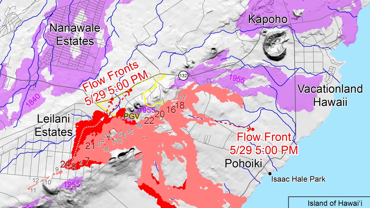
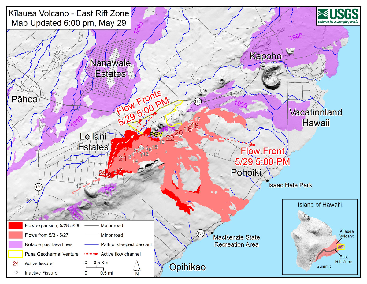
(BIVN) – A fast moving lava flow, fed by a towering Fissure 8 in Leilani Estates, is gained speed and is now advancing rapidly, emergency officials say, putting residents downslope at risk of isolation.

In a midnight message, Hawaii County Civil Defense announced the Kapoho area – including Kapoho Beach Lots and Vacationland – are advised to evacuate. “You are at risk of being isolated due to possible lava inundation of Beach Road near Four Corners,” civil defense said. “At the present rate of flow, it is possible that Beach Road near Four Corners may be blocked within 4 to 6 hours.”

Just after midnight, the USGS Hawaiian Volcano Observatory said the flow had advanced ~800 yards over 80 minutes. The flow is fed by continued strong fountaining from Fissure 8.

At 2:30 a.m., USGS said the Fissure 8 flow left Highway 132 in the vicinity of Noni Farms road, “and is following a steepest line of descent that would take it to Four Corners. Recent advance rates are about 200 yards/hour. F8 fountains remain strong.”

Shelters are open at the Pahoa Community Center, Kea’au Community Center and the Sure Foundation Church. Shelters are pet friendly.


Filed Under: Breaking Tagged With: Kapoho, Vacationland

LATEST NEWS

Critical Habitat Proposed For 12 Species Found Only On Hawaiʻi Island

Delays Reported In Kilauea Recovery Road, Waterline Projects

Hawaiʻi COVID-19 Update for Wednesday, March 29

Mass Dolphin Harrassment In Hōnaunau Under Investigation

East Hawaiʻi Police Officer, Firefighter Of The Year Named

Bathroom Burns Down At Old Airport Park In Kona

About Big Island Video News

  • Privacy Policy

Copyright © 2023 · Dynamik-Gen on Genesis Framework · WordPress · Log in