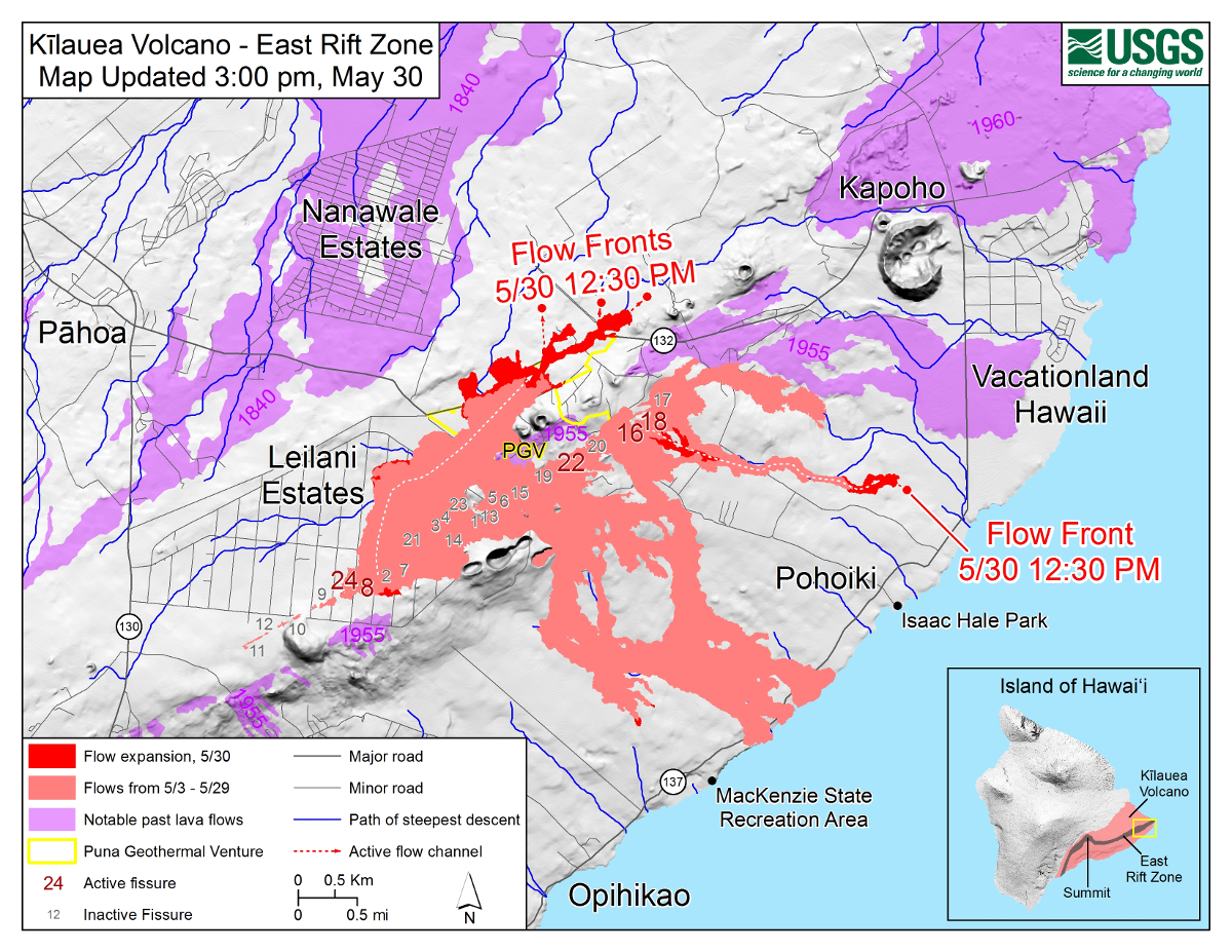
Map as of 3:00 p.m. HST, May 30, 2018. Given the dynamic nature of Kīlauea’s lower East Rift Zone eruption, with changing vent locations, fissures starting and stopping, and varying rates of lava effusion, map details shown here are accurate as of the date/time noted. Shaded purple areas indicate lava flows erupted in 1840, 1955, 1960, and 2014-2015.
(BIVN) – Lava from several fissures continues to move through Leilani Estates, Lanipuna Gardens and towards the Kapoho area, civil defense reports this morning.
“Hawaii Fire Department reports that a fast moving flow in the area of Noni Farms Road is heading toward the Waa Waa area,” county emergency officials stated. “Residents of Government Beach Road, Kapoho Beach Lots and Vactionland area at risk for isolation or lava inundation should a flow reach that area and are advised to evacuate due to the possibility.”
The lava, produced by Fissure 8, is following a steepest descent path towards Four Corners, and is 2.2 miles from that junction, according to helicopter observations made at 6:15 a.m. HST, the USGS Hawaiian Volcano Observatory reported.
At 3 a.m., USGS reported “overflows from west side of the F8 flow at Makamae street in Leilani Estates have moved north and crossed Kahukai as part of a small breakout. Lava is filling a low area at the Makamae/Kahukai intersection.”
Due to the volcanic activity, civil defense says the following policies are in effect:
- Evacuation area residents including Leilani Estates, Government Beach Road, Kapoho Beach Lots and Vacationland with approved credentials are allowed to enter from 7 a.m. to 6 p.m. This curfew is strictly enforced for your safety.
- Placards to reenter these areas are available at the Disaster Information Center at the Pahoa Community Center Monday thru Friday 9-3.
- Highway 132 is closed.
- Residents close to any volcanic activity should remain alert and be prepared to voluntarily evacuate if necessary.
- Stay tuned to local radio stations for updates from Civil Defense.

by Big Island Video News
on at
STORY SUMMARY
PUNA, Hawaii - Residents of Government Beach Road, Kapoho Beach Lots and Vactionland area at risk for isolation or lava inundation and are advised to evacuate due to the possibility.