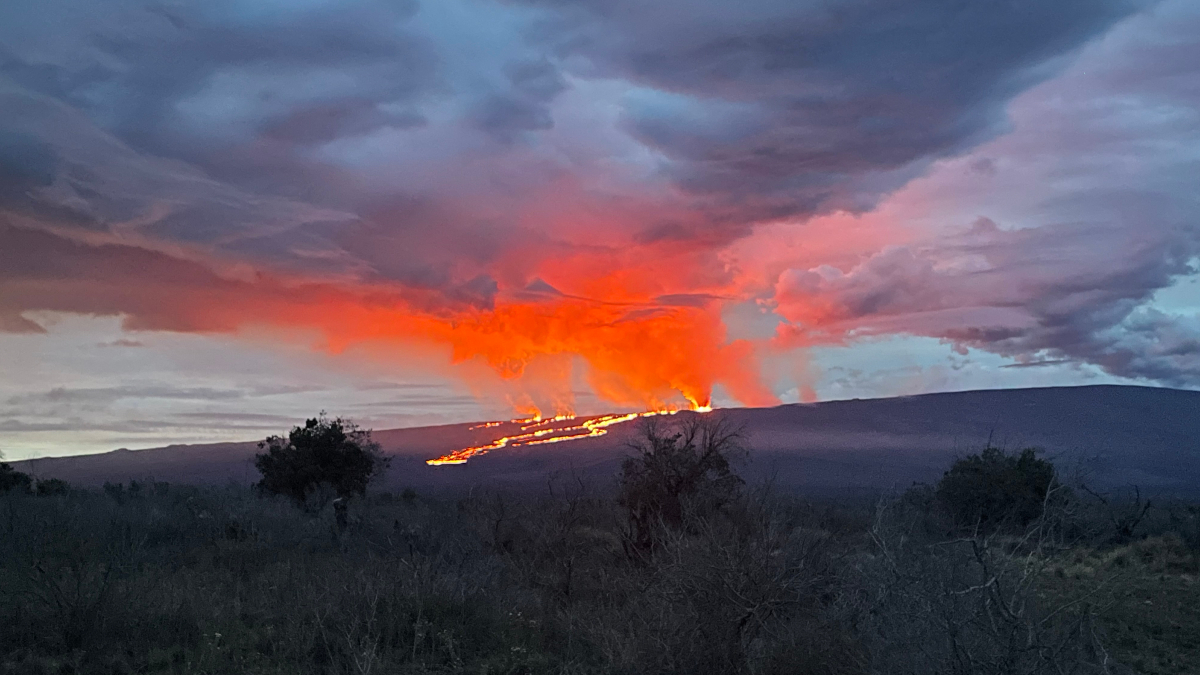
USGS: “Photograph taken from Saddle Road at 6AM Hawaii time on November 29, 2022 shows lava flows moving northeast downslope of Mauna Loa volcano from the Northeast Rift Zone eruption.” (USGS photo)
(BIVN) – The eruption of Mauna Loa on the Northeast Rift Zone continued Tuesday morning. Here is the latest:
- No property is at risk currently.
- The longest and largest lava flow, issuing from Fissure 3, crossed the Mauna Loa Weather Observatory Road at approximately 8 p.m. on Monday night.
- Lava is 6 miles (10 km) from Saddle Road at 7 a.m. HST this morning. The flow is estimated to be moving less than a mile per hour.
- A new fissure (Fissure 4) opened at approximately 7:30 p.m. HST on Monday night downrift of Fissure 3.
- The State of Hawaiʻi announced the closure of Unit J of the Kapāpala Game Management Area until further notice.
From the USGS Hawaiian Volcano Observatory at 9:12 a.m. HST:
The Northeast Rift Zone eruption of Mauna Loa continues, with several fissures and lava flows active. Several lava flows are traveling in a northeast direction. The longest and largest lava flow is issuing from fissure 3. This lava flow crossed the Mauna Loa Weather Observatory Road at approximately 8 p.m. yesterday evening, November 28, and the flow front was located approximately 6 miles (10 km) from Saddle Road at 7 a.m. HST this morning.
This morning, fountains at fissure 3 are up to 25 m (82 ft) and fountains are fissure 4, which formed at approximately 7:30 p.m. HST last night, were 5-10 m (16-33 ft) tall.
There is no active lava within Moku’āweoweo caldera, and there is no lava erupting from the Southwest Rift Zone. All lava flows are on the northeast flank of Mauna Loa. We do not expect any eruptive activity outside the Northeast Rift Zone. No property is at risk currently. There is a visible gas plume from the erupting fissure fountains and lava flows, with the plume primarily being blown to the North.
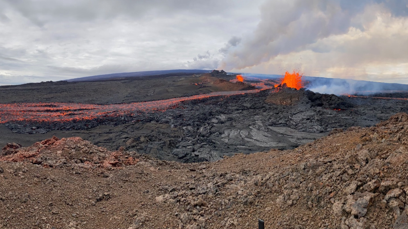
USGS: “A view of fissure 4 erupting on the Northeast Rift Zone of Mauna Loa, taken at approximately 8 a.m. HST November 29, 2022. Fissure 4 formed at approximately 7:30 p.m. HST November 28, and this morning the fountains there were 5-10 m (16-33 ft) tall.” (USGS photo by F. Trusdell)
From the Hawaiʻi Department of Land and Natural Resources:
As lava continues to flow into the Northeast Rift zone from Mauna Loa’s summit caldera, the DLNR Division of Forestry and Wildlife (DOFAW) is closing additional recreation areas on the mountain.
Unit J of the Kapāpala Game Management Area is closed until further notice. DOFAW Hawai‘i Island Branch Manager Steve Bergfeld said, “No one should be accessing Mauna Loa at this time. Our sole focus is on public safety, which depends on where lava ultimately flows.”
On Monday, DOFAW announced the closure of the entire Mauna Loa Forest Reserve, a massive 50,000-acre area. In addition, Bergfeld decided to close the Kīpuka ʻĀinahou Nēnē Sanctuary, ʻĀinapō Trail and cabin, and the Kapāpala Forest Reserve. All areas will be closed for 90-days.
Earlier, the National Park Service closed access to the Mauna Loa summit from the south, due to the initial period of volcanic unrest. Jack Corrao, Chief Ranger at Hawai’i Volcanoes National Park, stated, “As part of our eruption response plan, Hawai‘i Volcanoes has implemented further closures to the main, easy, access points that lead up to the Mauna Loa Summit. These include the Mauna Loa Observatory Access Road through Hawai‘i County and Mauna Loa Road, known locally as “Strip Road.” These have been closed physically through barriers. Individuals attempting to access through these are subject to fines and arrest.”
Yesterday morning, officers from the DLNR Division of Conservation and Resources Enforcement (DOCARE) and the Hawai‘i Police Dept. established a roadblock at the intersection of Mauna Loa Observatory Access Road and Daniel K. Inouye Highway (Saddle Road). It is being manned 24-hours-a-day.

by Big Island Video News
on at
STORY SUMMARY
HAWAIʻI ISLAND - While no property is at risk at this time, the lava is 6 miles away from Saddle Road. Also, a new fissure is erupting lava on the rift.