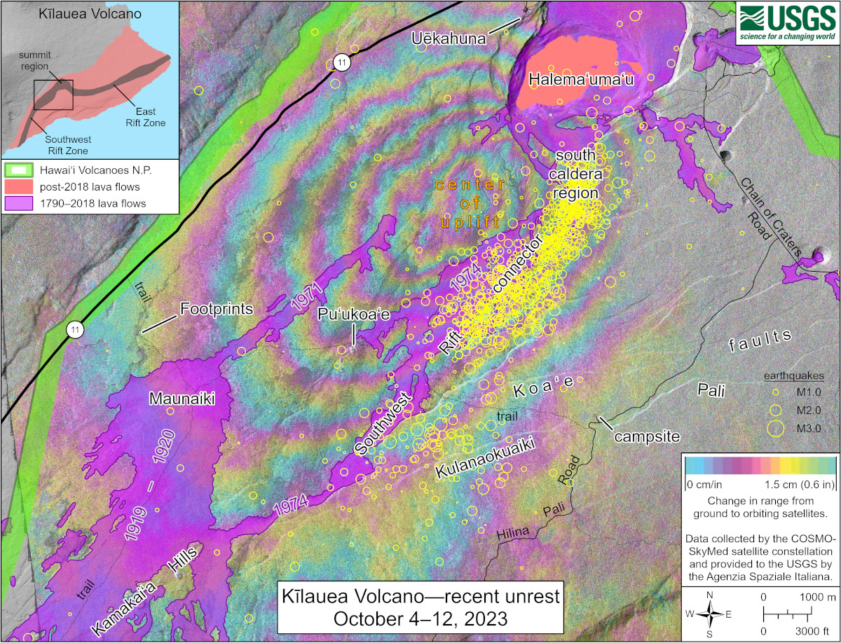
USGS: “This map shows recent unrest in Kīlauea’s summit region. Colored fringes denote areas of ground deformation and yellow circles denote earthquake locations.”
(BIVN) – A new map produced by the USGS Hawaiian Volcano Observatory shows the recent uplift in an area south of Kīlauea caldera in Hawaiʻi Volcanoes National Park.
Kīlauea is not erupting, and an eruption is not imminent. However, the recent changes in deformation and seismicity are indicative of episodic heightened unrest, and scientists have stated that an eruption in the region could emerge with little notice.
The number of earthquakes in this area appears to have decreased as of Friday morning. The USGS Volcano Alert Level remains at ADVISORY.
The USGS Hawaiian Volcano Observatory also provided this lengthy caption explaining the new map:
A radar interferogram, spanning the morning of September 24 until October 10 at about 6 a.m. HST shows approximately 10 cm (4 inches) of uplift or inflation of the area southwest of Kīlauea’s summit caldera over that time. Each color cycle represents 1.5 cm (0.6 in) of ground motion toward the satellite (indicating uplift/inflation). Data are from the COSMO-SkyMed constellation of radar satellites, provided by the Italian Space Agency (Agenzia Spaziale Italiana) through the Hawaiʻi Supersite. Tiltmeters and GPS stations in this region indicate that most of this deformation occurred since the beginning of October, with lower rates of ground deformation over the past day.
Elevated earthquake activity was also recorded over the past week beneath the south end of Kīlauea caldera and extending southwest along the Southwest Rift connector. Since October 4, over 1,200 earthquakes were recorded in this region at depths of around 1–5 km (0.6–3 mi) below the surface. Most were smaller than magnitude 1, though the largest event was a magnitude 2.8. Over the past day, earthquake activity in this region has greatly decreased.
The Southwest Rift connector―labelled on the map―is an underground passageway for magma into the Kīlauea Southwest Rift Zone, and for decades it has been a known source area for seismicity. Most recently, an intrusive event took place in this area during August of 2021 (August 30, 2021—Summary map of intrusive activity at Kīlauea Volcano―August 23–30, 2021). The connector region is offset to the southeast from the main lineament of eruptive vents marking the Southwest Rift Zone, as evidenced by the 1971 eruptive vents and 1919–1920 Maunaiki lava shield on the map. Eruptions from the connector itself are thought to be rare, though a brief but spectacular eruption occurred in this area on December 31, 1974, producing a lava flow that travelled more than 12 km (7.5 mi) to the southwest.
The current seismicity and deformation are thought to represent an intrusion of magma into the Southwest Rift connector, similar to that which occurred in August 2021 and many other times previously. Despite this elevated unrest, there is currently no indication of an imminent eruption in the region. HVO scientists continue to track monitoring data carefully.

by Big Island Video News
on at
STORY SUMMARY
HAWAIʻI ISLAND - The map shows recent changes in deformation and seismicity that are indicative of episodic heightened unrest.