(BIVN) – Kīlauea volcano is not erupting as of Thursday morning, and the USGS alert level remains at WATCH. Earthquake rates are high and the scientists say the activity “remains heightened and dynamic.”
On Wednesday, Hawaiʻi Volcanoes National Park staff reported “rock falls, wispy plumes of volcanic gas and felt earthquakes.”
Visitors to the park should “be prepared for crowded parking lots, stay away from the crater’s edge, stay on trail, and stay out of closed areas,” the National Park Service wrote in social media. No new closures in the park have been announced due to the uptick in volcanic activity as of Thursday morning.
From a Wednesday evening update by the USGS Hawaiian Volcano Observatory:
Activity beneath Kīlauea’s summit remains heightened and dynamic. The increase in seismicity and deformation that began in the south caldera region early this morning has fluctuated in intensity throughout the day but remains high overall. Kīlauea’s summit is pressurized; an eruption could occur with little warning. Increased seismicity and deformation remain restricted to the summit region and no unusual activity has been noted in the East Rift Zone or Southwest Rift Zone.
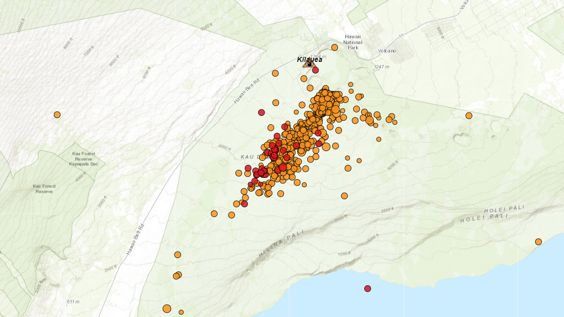
Since 3:00 a.m. HST, the number of detected earthquakes per hour has varied between 25-40. These events have occurred at depths of 1.5–3 km (1–2 mi) below the surface in clusters that have migrated between the area just south of Halema’uma’u and the region southwest of the outer caldera boundary. In total, there have been over 500 located earthquakes in this region since midnight, with magnitudes ranging from a maximum of 3.4 to less than 1, and more than 1,400 earthquakes since 9 a.m. HST on Saturday January 27th. Several of these earthquakes were large enough to be felt by neighboring communities, though none have been large enough to cause damage. The stronger earthquakes also continue to trigger rockfalls within Halemaʻumaʻu.
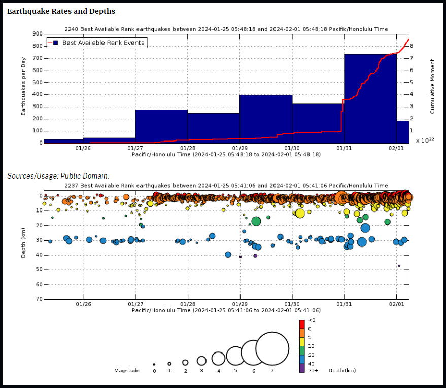
(From the USGS HVO) Above Top: Number of earthquakes per day during the past week (blue bars). The red line is the cumulative moment (energy) release. Bottom: Depth of earthquakes during the past week in the area shown on the map above. Depth is reported relative to sea level, which is equal to a depth of zero on the above plot. On both figures, circle-size represents magnitude, and color indicates depth.
Tiltmeters at Sand Hill and Uēkahuna bluff have continued to show highly variable directions and rates of tilt throughout the day, typical of ground deformation coupled with shallow crack growth that can precede either an eruption or shallow intrusion. Approximately 20 microradians of change have been recorded since 4:00 a.m. HST. Step-wise changes in the tilt signals are attributed to the instruments being shaken by nearby earthquakes or rockfalls.
Patterns of ground deformation and earthquakes since this morning indicate that pulses of magma continue to move beneath the surface of the region south of Halemaʻumaʻu to the area southwest of Kīlauea’s caldera. At the time of this report, activity remains elevated; periods of increased earthquake activity and rates of ground deformation can be expected to continue.
Current monitoring data show no indication that an eruption associated with this activity could occur far from Halemaʻumaʻu or the nearby area just to the south. Current wind conditions are weak and out of the south, so strong degassing could impact areas of Hawaiʻi Volcanoes National Park and surrounding communities if an eruption does occur in the summit region.
HVO continues to closely monitor the increased activity on Kīlauea volcano and remains in close contact with officials at Hawaiʻi Volcanoes National Park. Staff are watching for any signs of accelerated rates of earthquakes or ground deformation, or signs of shallowing earthquake locations, which usually precede a new outbreak of lava or propagating dike. We are also closely monitoring gas emissions and webcam imagery.

by Big Island Video News
on at
STORY SUMMARY
HAWAIʻI VOLCANOES NATIONAL PARK - Kīlauea volcano is not erupting but the levels of unrest are high in the area south of the caldera summit.