A synthesized voice was utilized in the narration for this story.
(BIVN) – A strong earthquake shook the Island of Hawaiʻi on Friday, just after 10 a.m. HST.
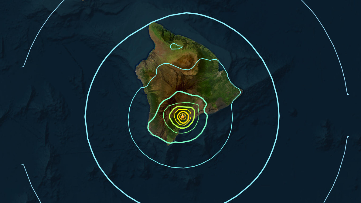
As of 10:45 a.m., scientists have settled on reporting the earthquake as a Magnitude 5.7, located deep under Pahala in the Kaʻū district. The earthquake was not strong enough to generate a tsunami.
Hawaiʻi County officials said just after 11 a.m. that “known damages primarily consist of minor landslides, resulting in debris on various roadways.”
“There have been no reports of significant damages beyond the aforementioned minor incidents,” the County said.
Scientists say the earthquake had no apparent impact on either Mauna Loa or Kīlauea volcanoes, neither of which are currently erupting. “Numerous aftershocks have been felt and are expected to continue,” the USGS Hawaiian Volcano Observatory reported, adding that the earthquake “is likely associated with lithospheric flexure caused by the weight of the Hawaiian Islands on the oceanic lithosphere.”
At first, the location of the earthquake was reported to be off the coast of Kaʻū, near the town of Naʻalehu. The depth was measured at around 6 miles below sea level. That location was later revised.
The Pacific Tsunami Warning Center initially reported the earthquake as a Magnitude 6.3, and reported that a tsunami is not expected.
The USGS Hawaiian Volcano Observatory initially measured the earthquake as a Magnitude 6.2. Later, the USGS updated the earthquake to a Magnitude 5.7, and located the earthquake southwest of Pahala, at a depth of over 21 miles.
It is likely these measurements will be further adjusted as scientists examine the data.
“If the earthquake was strongly felt in your area, please check for any damages, including but not limited to structural and gas, water, and electrical utilities,” said the Hawaiʻi County Civil Defense in an alert message. “If you have any damages you would like to report, please call Civil Defense at 808-935-0031.”
Friday’s deep earthquake followed a period of high seismicity and ground deformation at Kīlauea that started on January 27th, as magma intruded from the summit to the southwest. During this period, the USGS raised the alert level for the volcano from ADVISORY to WATCH. As of February 3rd, rates of seismicity and deformation have decreased, and the alert level was lowered back to ADVISORY.
This is a breaking news story. It will be updated as more information is learned.

by Big Island Video News
on at
STORY SUMMARY
ISLAND OF HAWAIʻI - The earthquake shook the Island of Hawaiʻi on Friday morning, just after 10 a.m. HST. No significant damage has been reported.