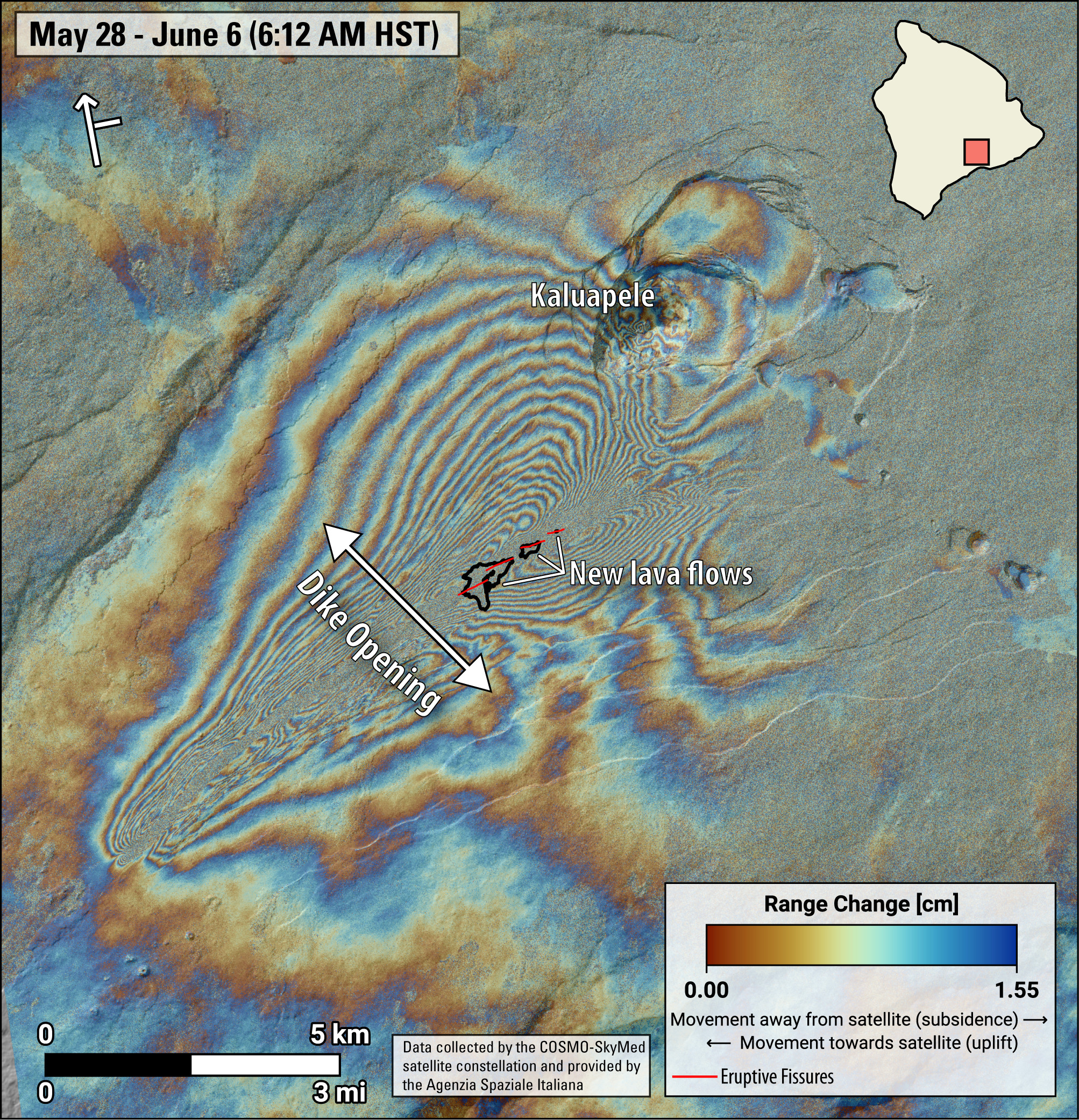
USGS: “This map shows recent deformation spanning the recent eruption at Kīlauea. It covers from May 28 to June 6, 2024, and is recorded by the Italian Space Agency’s (ASI) Cosmo-SkyMED satellite. Colored fringes denote areas of ground deformation, with more fringes indicating more deformation. Each color cycle represents 1.5 cm (0.6 in) of ground motion indicative of opening of a dike-like body trending northeast-southwest that fed the eruption. Red lines are the locations of fissures that were active during the eruption and black lines outline the recent lava flows. Arrow in the upper left indicates satellite orbit direction (arrow) and look direction (bar).”
(BIVN) – Kīlauea volcano is not erupting, and the USGS Alert Level remains at ADVISORY.
The eruption that began on Monday, June 3, on the upper Southwest Rift Zone has ended. However, scientists say “renewed pulses of seismicity and deformation could result in new eruptive episodes within the area or elsewhere within the summit region.”
Also, earthquake counts in the summit region remain elevated. Tremor has dropped to background levels.
This is the update provided by the USGS Hawaiian Volcano Observatory on Saturday, June 8:
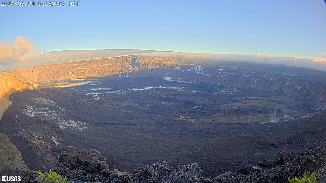
Eruption Site Observations: No lava is erupting. Glow from fissures vents continued to be visible in webcam imagery overnight but glow intensity was significantly lower than the previous night. Volcanic gas emissions at the eruption site are approaching background levels (100 tonnes per day or less). Total SO2 emission rates for the summit and eruption site of approximately 400 t/d were measured on June 6. Seismic activity remains low at the eruption site.
Summit and Upper Rift Zone Observations: Rates of seismicity beneath the summit, upper East Rift Zone, and upper Southwest Rift Zone were elevated over the past day. Tremor has decreased to background levels across the summit region. More than 170 earthquakes occurred over the past 24 hours. Earthquakes were mostly located beneath the south caldera region and upper East Rift Zone, at depths of 1.5-3 km (1–1.8 miles), with magnitudes under M2.5. Inflationary ground deformation of the summit continued over the past day. The Uēkahuna tiltmeter northwest of the summit recorded overall inflation of approximately 1 microradian over the past 24 hours. The Sand Hill tiltmeter southwest of the summit recorded approximately 6 microradians of inflation over the past 24 hours.
Lower Rift Zone Observations: Rates of seismicity and ground deformation beneath the middle and lower East Rift Zone and lower Southwest Rift Zone are low. Eruptive activity and unrest have been restricted to the summit and upper rift zone regions. Measurements from continuous gas monitoring stations downwind of Puʻuʻōʻō in the middle East Rift Zone remain below detection limits for SO2, indicating that SO2 emissions from Puʻuʻōʻō are negligible.
Eruption Summary: Emplacement of a magmatic dike began just after 12:00 p.m. HST on June 2, 2024, beneath the area of Kaluapele south of Halemaʻumaʻu. Seismicity continued to intensify beneath this area and HVO raised the alert levels from Advisory/Yellow to Watch/Orange as the dike shallowed. Around 8:00 p.m. on June 2 a strong deflation signal on the Sand Hill tiltmeter indicated that a significant mass of lava moved to another location despite a lack of seismicity. After the deflationary event, seismicity declined significantly, and it was no longer possible to track the underground location of the magma. Data from USGS webcams and Keck Observatory webcams determined that the eruption began at 12:30 a.m. June 3, and effusion at the vents remained active until approximately 9:00 a.m., though lava flows were moving sluggishly until about noon on June 3. Numerous large ground cracks formed in the vicinity of the eruption extending westward to within 540 yards (500 meters) of Maunaiki. Sulfur dioxide (SO2) emission rates of 12,000-15,000 t/d were measured on June 3, and 5,500 t/d on June 4.
Analysis: The last eruption in this area occurred in December 1974. The 1974 eruption lasted 6 hours and erupted 13 million cubic yards (10 million cubic meters) of lava that covered about 3 square miles (7 square kilometers). In contrast, the June 3, 2024, eruption lasted 8.5 hours but only erupted about 1% of the volume and covered about one third of a square mile (one half of a square kilometer). Lava from the fissure system covered approximately 90 acres (350,000 square meters), a relatively small area. The pasty surface textures of the erupted lava and the small amount of lava erupted suggests that this lava could have been first emplaced during the January 31, 2024, intrusive event and cooled prior to being forced to the surface by the new dike. Although the eruption has ended, renewed pulses of seismicity and deformation could result in new eruptive episodes within the area or elsewhere in the summit region.

by Big Island Video News
on at
STORY SUMMARY
HAWAIʻI VOLCANOES NATIONAL PARK - Earthquake counts in the Kīlauea summit region remain elevated, while tremor has dropped to background levels.