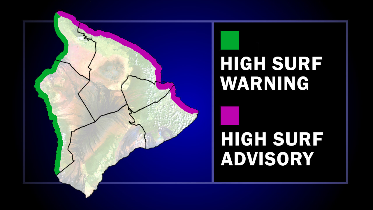
(BIVN) – A High Surf Warning is now in place for the west-facing shores of Hawaiʻi island, while a High Surf Advisory has been issued for north and east-facing shores.
The National Weather Service in Honolulu says a series of large northwest to north-northwest (315 to 330 degrees) swells will move through Hawaiian waters over the weekend and into early next week. Surf will build up to 35 feet along north facing shores Niʻihau, Kauai, Oʻahu, Molokai, and Maui.
Waves will be a little smaller along the shores of Kona and Kohala, where surf heights of 10 to 14 feet are expected.
“Warning level surf will prevail along north and west facing shores of the smaller islands through the weekend, with a brief dip possible late Saturday and Saturday night,” the National Weather Service said. “Warning level surf will prevail across west facing shores of the Big Island, while advisory level surf is expected along north facing shores there.”
From the NWS discussion posted on Friday night:
An extended period of hazardous marine conditions will persist into early next week, driven by overlapping, winter-caliber northwest swells associated with a progressive storm pattern across the northern Pacific. This pattern features storm- to hurricane-force lows advancing eastward well north of the state. Recent satellite data and observations indicate a hurricane-force low centered approximately 1,300 nautical miles north-northwest of the islands, with seas in the core of its fetch measured between 45 and 60 feet. A SOFAR drifter buoy recorded seas up to 60 feet, exceeding model forecasts by several. While the bulk of the energy from this system is directed northeast of Hawaii due to the west-to-east fetch orientation, the head of the fetch is expected to nose southward to within 600 nautical miles of the islands over the next 24 hours. This southward extension increases confidence in the predicted timing of the swell’s arrival Saturday night, followed by a rapid rise early Sunday morning, a peak through the day Sunday, and a gradual decline Sunday night into early next week. Surf associated with this activity will remain well above warning levels through the weekend, then return to advisory levels for exposed north and west facing shores around Tuesday of next week.
The prolonged duration of this active period will lead to coastal impacts, including significant beach erosion along exposed shorelines and potential overwash onto vulnerable coastal roadways and properties, especially during Sunday’s peak. These impacts will remain likely despite the monthly tidal minima, underscoring the significance of the swell. In addition to the coastal impacts, these conditions maybe be challenging for mariners transiting in and out of exposed harbors, where strong currents and occasional breaking waves are expected.

by Big Island Video News
on at
STORY SUMMARY
HAWAIʻI ISLAND - Also, a High Surf Advisory has been issued for north and east-facing shores of the Big Island.