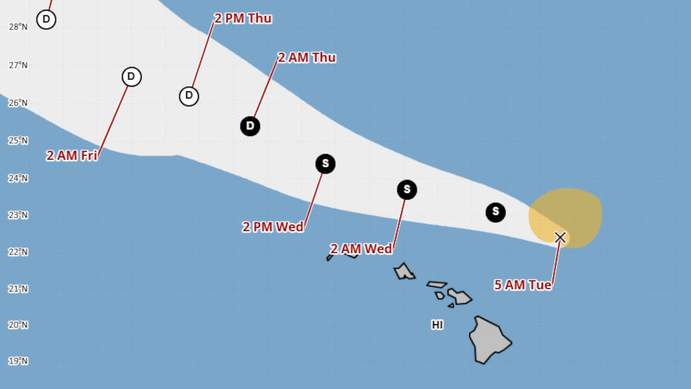
(BIVN) – Kiko weakened to a tropical storm overnight. The storm was located 215 miles north-northeast of Hilo on Tuesday morning, moving west-northwest at 14 mph. Maximum sustained winds have decreased to near 45 mph.
Tropical Storm Kiko will pass north of Hawaiʻi island today, with little impact on the Big Island aside from some brief heavy downpours, and the possibility of an isolated thunderstorm over interior areas.
A High Surf Warning is in effect until Tuesday evening, as “dangerously large breaking waves of 10 to 15 feet” will be possible along east-facing shores. From the National Weather Service in Honolulu:
The latest buoy observations from Hilo showed a rise in energy across the 12-14 second spectral bands during the evening, and throughout the night. With Kiko expected to make its closest approach to the Hawaiian Islands during the next 12-24 hours, we expect another quick rise in wave heights over the western half of the state today. Although peak surf heights are expected to be short-lived, a rapid rise of east swell should produce dangerous conditions along east facing shores. A High Surf Warning remains in effect for the Big Island, Maui, and Molokai, and starts for Oahu and Kauai this morning. Surf heights are expected to have peaked for the Big Island over the next couple of hours, for Maui County in the next few hours, and mid day into the afternoon for Oahu and Kauai.
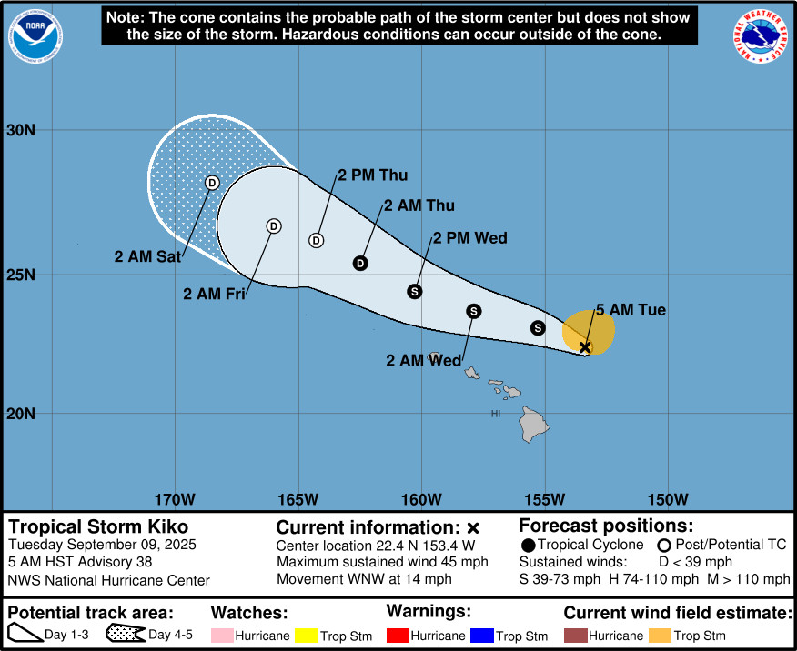
From the National Hurricane Center discussion posted at 5 a.m. HST:
Kiko has continued to weaken this morning in a high shear environment, with deep convection being displaced well north of the exposed low-level center. The latest trends in both subjective and objective satellite intensity estimates continue to decrease, ranging from 25 to 45 kt. Given the trends with these estimates, the initial intensity is lowered to 40 kt for this advisory.
The initial motion is west-northwestward at an estimated motion of 290/13 kt. The system has decoupled and the shallow vortex is being steered along the southwestern periphery of the subtropical ridge. This west-northwestward to northwestward motion is anticipated throughout the forecast period. The official forecast track is similar to the previous, with maybe a slight nudge to the left in the short term, and lies near the HCCA corrected-consensus and Google DeepMind aids.Southwesterly shear continues to takes its toll on Kiko, displacing any convection to the north. The shear is expected to remain high over the next 24 hours. Shear decreases slightly between 48-60 h, with the system over warm sea surface temperatures. Forecast simulated satellite imagery shows that occasional bursts of convection are possible and Kiko may be able to sustain its tropical cyclone status. Beyond 60 h, shear increases once again and the system should continue to weaken and dissipate. The latest NHC forecast shows the system continuing to weaken and given the increased shear again at 60 h, the system is now expected to become a post-tropical cyclone. Global models depict the system slowly spinning down and the official forecast follows those trends, showing the cyclone dissipating by the end of the forecast period. It is noted that if Kiko does not produce organized convection soon as models show, the system may become post-tropical earlier than officially forecast.
Key Messages:
1. Kiko is forecast to pass north of the Hawaiian Islands today and Wednesday. Additional weakening is expected, and the threat of direct impacts on the islands continues to diminish, though interests should still monitor Kiko’s progress and the latest forecasts.
2. Swells generated by Kiko are gradually building from east to west across the exposed Hawaiian waters and are forecast to peak today through Wednesday, potentially producing life-threatening surf and rip currents. Refer to the latest updates and forecasts issued from the National Weather Service in Honolulu, Hawaii.

by Big Island Video News
on at
STORY SUMMARY
HAWAIʻI - Weakening Tropical Storm Kiko will pass the Hawaiian islands to the north today, producing high surf but little other impacts.