(BIVN) – The ongoing eruption at the summit of Kīlauea remains paused, although the next episode of high lava fountaining is near.
When the lava fountains do erupt, they will likely add more tephra to the growing puʻu on the rim of the Halemaʻumaʻu crater. It is the topic of the latest Volcano Watch article by the USGS Hawaiian Volcano Observatory.
From this week’s article, written by HVO geologist Natalia Deligne:
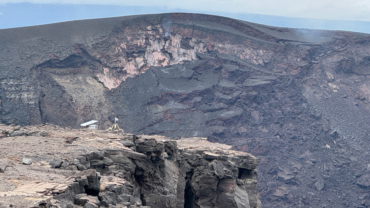
Tephra formed by lava fountains during the ongoing Kīlauea summit eruption has created a new puʻu (hill) southwest of Halemaʻumaʻu crater. The new puʻu is visible from the public viewing areas around Kīlauea summit in Hawaiʻi Volcanoes National Park. The USGS Hawaiian Volcano Observatory (HVO) has been busy tracking the continued growth of this young geologic feature.
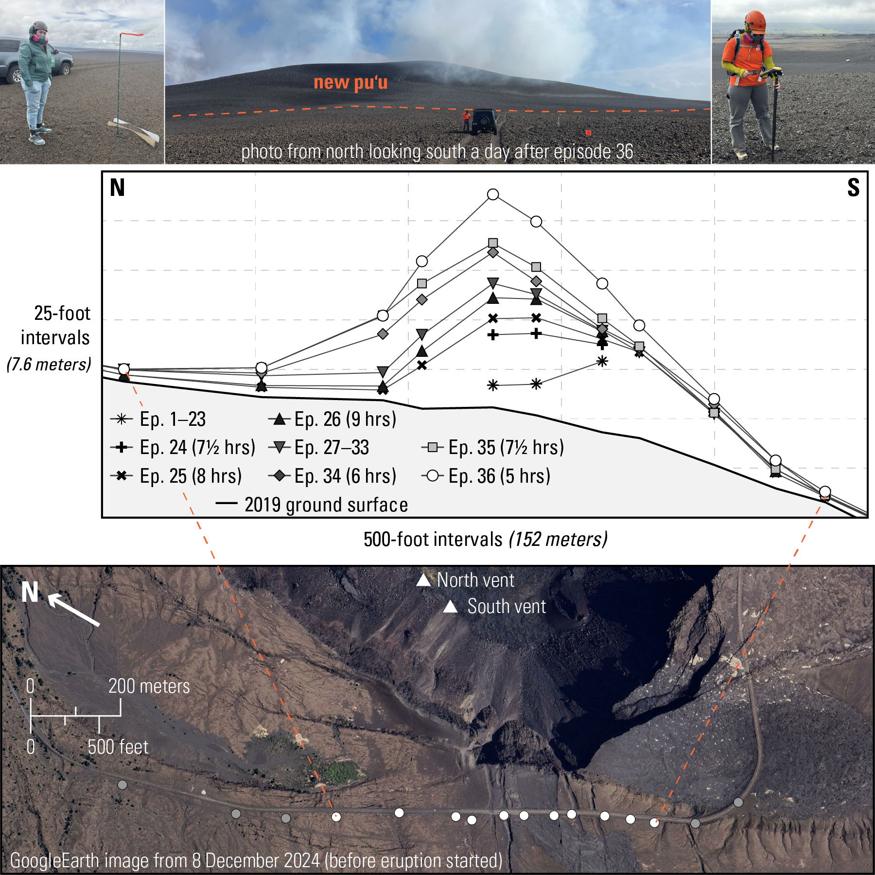
Top left photo: scientist stands next to a garden stake with 20-cm (8-in) intervals marked in blue, next to an old road sign that had been progressively buried by tephra during episodes 1-21; this photo was taken May 15. The next day, episode 22 completed buried the garden stake. Top middle photo: view of the new puʻu a few days after episode 36 on November 10. Top right photo: scientist takes a precise GPS location measurement from the top of the new puʻu; a parked vehicle at the base of the puʻu is visible in the middle right of the photo. Middle panel: profiles of the growing puʻu, showing how the puʻu has changed through the end of episode 36. Episode 37 is not shown because the puʻu had minimal growth. Bottom panel: Map showing where the GPS measurements are taken; image taken 16 days before the eruption started in December 2024. The white dots correspond to the profile shown in the middle panel.
Tephra is a piece of rock ejected during an eruption, and it includes Pele’s hair. While tephra has been falling on a closed portion of Crater Rim Drive since the current eruption started, the development of a new puʻu started in late March and early April. Initially, HVO geologists informally tracked the accumulation of tephra by photographing the progressive burial of a road sign. By the end of episode 21 on May 11, only an inch or two of the sign remained exposed; clearly this was not going to work for much longer.
Before and after episode 22, geologists established a series of garden stakes, each about 5 feet tall, at regular intervals along the closed road. The intention was to measure how much tephra fell at each location following an episode—similar to how a rain or stream gauge measures rainfall or water level at a particular location. This plan did not work well, either: episode 23 on May 25 buried five of the twelve stakes, and episode 24 on June 4 buried an additional three.
Low-tech methods were failing due to how much the puʻu was growing during lava fountaining episodes. Higher-tech methods required walking transects by foot using a hand-held, high-precision GPS instrument. This was first trialed at a few points after episodes 23 and 24, with complete transects done along then-buried Crater Rim Drive starting after episode 25.
GPS measurements are taken at several locations, including the closest stable location near the peak of the puʻu (the exact location of the peak changes between episodes, and slumping/cracking near the peak can make the very top unsafe). Once the geologist is at a measurement site, the instrument must first see enough satellites (usually between 10 and 20) to have a vertical accuracy of 30 centimeters (1 foot) or less. This takes between a few seconds to several minutes. Next, a location datapoint is recorded every second for 240 seconds (4 minutes).
The whole transect takes 2-3 hours to complete. Once back in the office, the data is processed by using a permanent GPS monitoring station nearby for corrections. The final averaged locations at each site have a vertical accuracy on the order of 10 centimeters (4 inches) or so. The data allows us to track how the puʻu is growing over time. The original ground surface was taken from high-precision elevation data collected using lidar (light detection and ranging) in 2019.
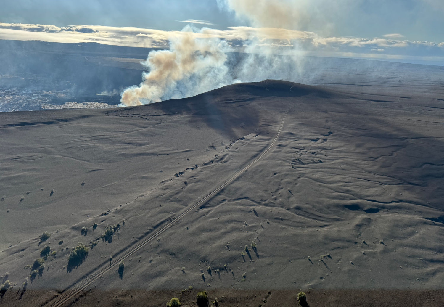
USGS: “The north and south vents were degassing during a USGS Hawaiian Volcano Observatory monitoring overflight of Kīlauea summit on December 2, 2025. Eruptive activity at these vents was paused on December 2, following 9 hours of lava fountaining during episode 37 on November 25, but a spattering lava surface was visible deep within both vents.” (USGS photo by K. Mulliken)
HVO has also done a few surveys of the new puʻu using its new helicopter-mounted airborne lidar system, which provides high-resolution three-dimensional topographic scan of the entire puʻu. This is done about once a month, but processing the data is complex and still ongoing. Unfortunately, attempts to use photogrammetry methods—how HVO tracks elevation changes across the crater floor—have been unsuccessful because the new puʻu’s surface is too uniform and lacks consistent distinguishable features.
The dataset shows how much the new puʻu can grow in just a few hours during lava fountaining episodes. For example, at the location of the now-buried road sign, the tephra deposit was a total of 3.4 meters (11 feet) thick on May 31, 2025, after episode 23. At the same site, episode 24, over about 7½ hours, added an additional 7.8 meters (25.6 feet) of tephra, while episode 36 added an additional 7.5 meters (24.6 feet) in just 5 hours!
The puʻu grows the most during high-fountaining episodes that exceed 300 meters (1,000 feet) in height. When lava fountains are below the rim, it is harder for tephra to make its way out of Halemaʻumaʻu onto the new puʻu. Pele is now building where 17 years ago visitors used to drive around Halemaʻumaʻu from the now-removed Jaggar Museum to the now-gone Halemaʻuamaʻu Overlook. HVO geologists will continue to track the evolution of this new feature on Kīlauea, which serves as a great example of how quickly Hawaiian volcanoes can change their landscape.

by Big Island Video News
on at
STORY SUMMARY
HAWAIʻI VOLCANOES NATIONAL PARK - Scientists write about how they are tracking the growth of the tephra hill on the rim of the Kīlauea caldera.