 HONOLULU, Hawaii – A magnitude 7.4 earthquake has struck south of the Fiji Islands, but no Pacific wide tsunami is expected and there is no tsunami threat to Hawaii.
The Pacific Tsunami Warning Center says based on all available data a destructive tsunami has not been generated.
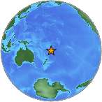
The quake happened 106 miles below the ocean, and was actually closest to Vaini, Tonga (174 miles to southwest.)
The quake was 441 miles southeast of Suva, Fiji.
According to the United States Geological Survey, the Eastern Margin of the Australia Plate, which stretches from New Zealand to the east of Tonga and Fiji, is highly active.
From the USGS Tectonic Summary:
The eastern margin of the Australia plate is one of the most sesimically active areas of the world due to high rates of convergence between the Australia and Pacific plates. In the region of New Zealand, the 3000 km long Australia-Pacific plate boundary extends from south of Macquarie Island to the southern Kermadec Island chain. It includes an oceanic transform (the Macquarie Ridge), two oppositely verging subduction zones (Puysegur and Hikurangi), and a transpressive continental transform, the Alpine Fault through South Island, New Zealand.
Since 1900 there have been 15 M7.5+ earthquakes recorded near New Zealand. Nine of these, and the four largest, occurred along or near the Macquarie Ridge, including the 1989 M8.2 event on the ridge itself, and the 2004 M8.1 event 200 km to the west of the plate boundary, reflecting intraplate deformation. The largest recorded earthquake in New Zealand itself was the 1931 M7.8 Hawke’s Bay earthquake, which killed 256 people. The last M7.5+ earthquake along the Alpine Fault was 170 years ago; studies of the faults’ strain accumulation suggest that similar events are likely to occur again.
North of New Zealand, the Australia-Pacific boundary stretches east of Tonga and Fiji to 250 km south of Samoa. For 2,200 km the trench is approximately linear, and includes two segments where old (>120 Myr) Pacific oceanic lithosphere rapidly subducts westward (Kermadec and Tonga). At the northern end of the Tonga trench, the boundary curves sharply westward and changes along a 700 km-long segment from trench-normal subduction, to oblique subduction, to a left lateral transform-like structure.

by Big Island Video News
on at
STORY SUMMARY
HONOLULU, Hawaii – A magnitude 7.4 earthquake has struck south of the Fiji Islands, but no Pacific wide tsunami is expected and there is no tsunami threat to Hawaii. The Pacific Tsunami Warning Center says based on all available data a destructive tsunami has not been generated. The quake happened 106 miles below the ocean, […]