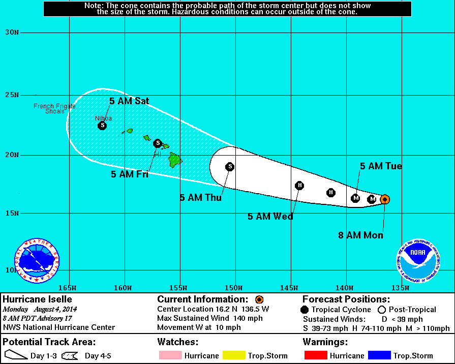
(above) There is a little change in the predicted path of Hurricane Iselle, as the National Weather Service 5-Day Forecast Cone shows.
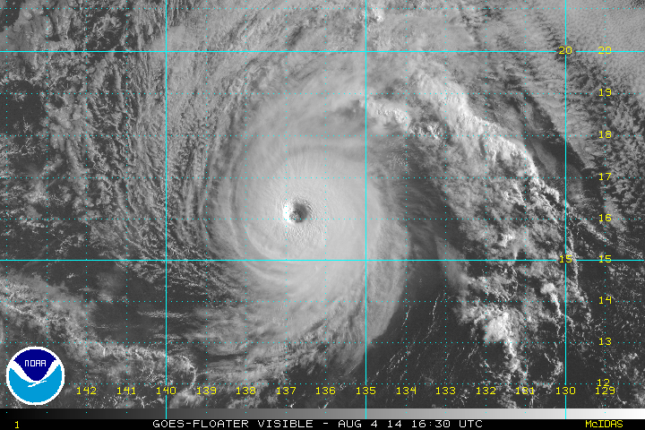
HILO, Hawaii – Iselle is on its way towards Hawaii, and now its a category 4 hurricane.
Wind speeds reached 140 miles per hour overnight. Iselle is 1,245 miles east of Hilo, and moving towards the islands at 10 miles per hour. The National Weather Service still believes Iselle will weaken to a tropical storm by the time it nears the Big Island of Hawaii on Thursday evening.
The eye of the storm has grown to a diameter of 25 to 30 nautical miles. Initially forecast to weaken by now, Iselle is behaving like an annular hurricane, which means it is not prone to the fluctuations in intensity like typical tropical cyclones. Annular tropical cyclones tend to persist, according to Wikipedia, even when encountering environmental conditions which easily dissipate most other tropical cyclones.

Since Iselle has some characteristics of an annular hurricane, it is likely to change little in intensity during the next day or so, and even when it begins to weaken, the trend should be gradual. On day 3, Iselle will be moving over the coldest water (between 25 and 26C) along its forecast track, and vertical shear is expected to increase to about 15-20 kt. Both factors should induce quicker weakening at that time. The NHC intensity forecast remains above all of the typically used intensity models during the first 24 hours, is very close to the consensus on days 2-3, and then more closely follows the decay shown by the LGEM model toward the latter part of the forecast period.”National Weather Service in 5 a.m. HST discussion
Meteorologists also talked about the forward progress of the storm.
Iselle’s initial motion is 275/9 kt. A mid- to upper-level shortwave trough is swinging by to the north of the hurricane and eroding the subtropical ridge, which should cause Iselle to slow down a bit during the next 24 hours. After that time, a mid-level high is forecast to develop and strengthen between Hawaii and California, forcing Iselle to turn west-northwestward and accelerate as it approaches and moves near the Hawaiian Islands. The track guidance has been stable and tightly clustered for a few cycles now, and no significant changes were required to the NHC track forecast.National Weather Service in 5 a.m. HST discussion