(Above) the latest 5 Day Forecast Track for Hurricane Iselle courtesy the National Weather Service
Hawaii County Civil Defense message at 8:30 p.m. HST
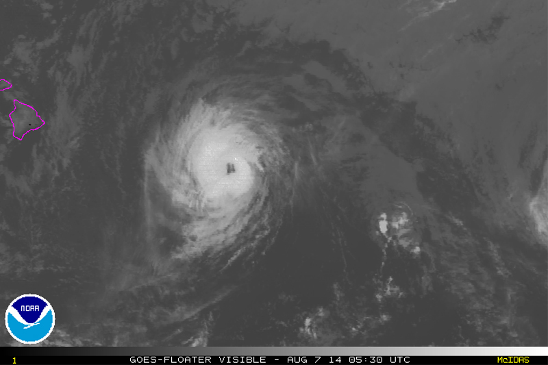
HILO, Hawaii – Hurricane Iselle is 450 miles east southeast of Hilo, and is heading towards the island at 18 miles per hour. With winds of up to 90 miles per hour, Iselle is still a strong Category One Hurricane. A Hurricane Warning remains in effect for Hawaii Island.
At 8:00 p.m. HST… 6:00 UTC… The center of Hurricane Iselle was located near latitude 18.0 north… Longitude 148.4 west. Iselle is moving toward the west-northwest near 18 mph… 30 km/h… And this motion is expected to continue for the next 48 hours. On the forecast track… The center of Iselle is expected to pass very near or over the Big Island Thursday night… And pass just south of the smaller islands Friday.
Maximum sustained winds are near 90 mph… 150 km/h… With higher gusts. Some weakening is forecast during the next 48 hours. However… Iselle is still expected to be near hurricane strength as it passes near or over the Big Island.
Hurricane force winds extend outward up to 45 miles… 75 km… From the center… And tropical storm force winds extend outward up to 140 miles… 220 km. The estimated minimum central pressure is 982 mb… 29.00 inches.National Weather Service at 8 p.m. HST
According to the National Weather Service, Hawaii Island can expect the following hazards as the storm arrives:
WIND
Tropical storm conditions are expected on the Big Island of Hawaii Thursday, with hurricane conditions expected Thursday night. Tropical storm conditions are expected for portions of Maui county Thursday night, and for Oahu late Thursday night and Friday. Tropical storm conditions are possible for Kauai county on Friday.
SURF
Swells generated by Iselle will continue to build along east facing shores tonight. Very large, damaging surf is expected along mainly east and south shores starting late tonight or Thursday.
RAINFALL
Rainfall totals of 5 to 8 inches, with isolated maximum amounts to 12 inches, are expected along the track of Iselle. These rains could cause life-threatening flash floods as well as rock and mud slides.
STORM SURGE
The combination of a dangerous storm surge and the tide will cause normally dry areas near the coast to be flooded by rising waters. The water could reach the following heights above ground if the peak surge occurs at the time of high tide,.
Big island windward and Kau, 1 to 3 ft.
The highest water will occur along the immediate coast in areas of onshore flow. The surge will be accompanied by large and damaging waves. Surge related flooding depends on the relative timing of the surge and the tidal cycle, and can vary greatly over short distances.

The National Weather Service Hurricane Warning for the Island of Hawaii remains in effect. The onset of hazardous hurricane conditions can be expected to affect the east or windward portions of Hawaii Island beginning tomorrow afternoon and as forecasted, continue across the island to the west. The hurricane conditions will include high surf and surge along all coastal areas, heavy rains and possible thunder showers that may present with flood conditions, and sustained storm force winds of over 75 mph and higher gusts. Hurricane Iselle continues to be monitored and is currently located approximately 550 miles east southeast of Hilo and moving west northwest at 16 miles per hour. Hurricane Iselle is maintaining its strength and track and will continue to be monitored. Additional updates will be broadcasted as information is made available. Residents in coastal areas and areas prone to surf and surge impact are advised to take precautions. All residents are encouraged to remain off the roadways and to anticipate possible power outages and interruptions in telephone and other communication systems.
The department of Education reports that all Hawaii Island Schools will be closed tomorrow Thursday August 7 and Friday August 8th. The following facilities will be opened for evacuation shelters effective 12:00 noon tomorrow:
Laupahoehoe School
Kohala High & Elementary
Kealakehe High
Konawaena High
Hilo High
Waiakea High
Keaau High
Pahoa High & Intermediate
Honokaa High & Intermediate
Kau High
Waikoloa Elementary
In addition, all beach parks will be closed effective tonight and remain closed until conditions improve and it is safe to reopen.
Lastly, all county and state government offices will be closed for general business operations effective 12:00 noon tomorrow Thursday August 7th and remain closed through Friday August 8th. Emergency operations will be maintained and all non-essential employees will be instructed to remain home. Civil Defense update for Wednesday August 6th at 8:30 PM