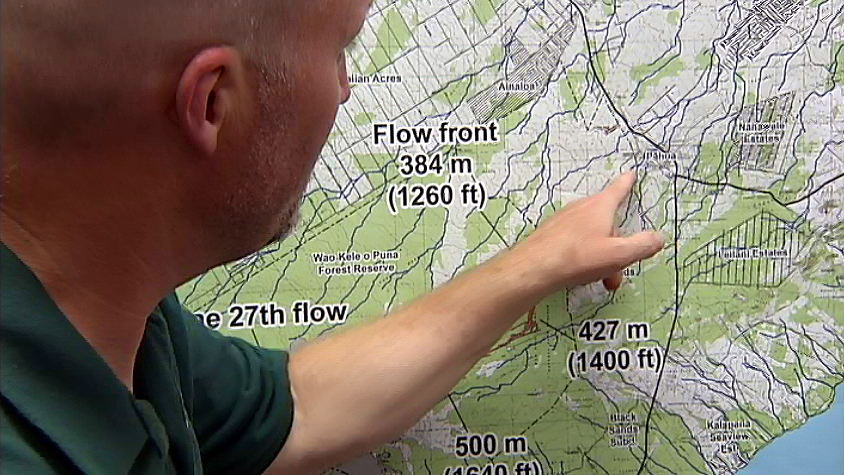
(ABOVE VIDEO) Mayor Billy Kenoi addresses the concerned crowd during Tuesday evening’s public meeting in Pahoa, while USGS geologist Tim Orr explains the latest observations – and projected paths – of the June 27 lava flow.
Video by David Corrigan
PAHOA, Hawaii – County officials spent another evening reassuring the public that their government is working on all contingency plans in the face of advancing lava, even as new flow projections disturbed residents.
The June 27 lava flow was .7 miles from the Wao Kele o Puna Forest Reserve boundary on Tuesday morning. It has traveled 8.7 miles from a vent on Pu’u O’o on Kilauea’s volcanic East Rift Zone, often making its way underground through the many cracks that line the forest. Now that the flow has emerged as a north-bound surface flow, scientists are more comfortable using the tools at their disposal to project where it will end up. Yesterday, the USGS Hawaiian Volcano Observatory stated in an advisory, “at the average rate of advancement of 400 m/day (1,300 ft/day) since September 6, we project that lava could flow from its current location either through the north part of Kaohe Homesteads, or to the north of Kaohe Homesteads, and reach the government road in Pāhoa within 16-18 days if lava is not further confined within the cracks and down-dropped blocks within the East Rift Zone of Kīlauea volcano.”
On Tuesday evening, the USGS HVO presented a visual aid for those projections. Some in the audience gasped as a new map was revealed, showing red lines indicating probable pathways, one of which covered old Pahoa town before heading in the direction of Hawaiian Beaches. USGS Geologist Tim Orr later explained the map in an interview with Big Island Video News (above).
Once again, the meeting had a question and answer session between residents and officials, and once again much of the discussion focused on the county’s plan for creating emergency escape routes in the event Highway 130 gets cut by lava (above video). Officials say the focus is on improving Railroad Avenue and Government Beach Road, but the plan could change as the direction of the lava flow becomes more certain.