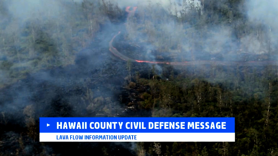
(ABOVE VIDEO) This morning’s Civil Defense message with video courtesy Ena Media Hawaii filmed on December 1.
NEWS BRIEFS
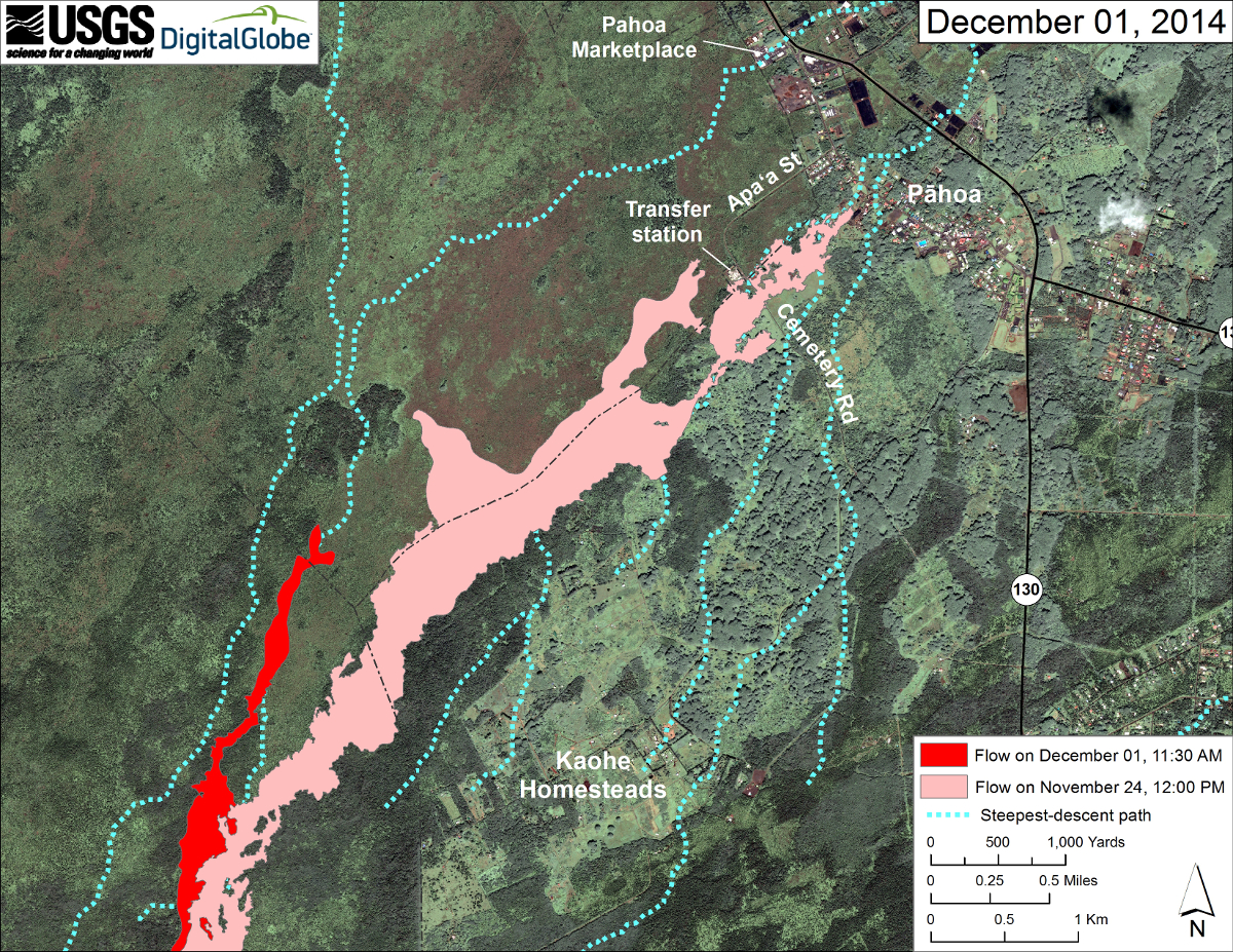
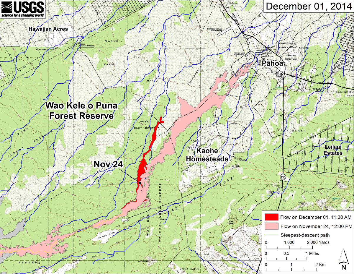
- The (new) active flow front is located 2.7 miles upslope of the Highway 130 and Pahoa Village Road intersection. The flow had advanced approximately 400 yards since yesterday.
- USGS Hawaiian Volcano Observatory says that until the flow reaches an area where “several lines of steepest descent nearly converge” about .6 miles away, “it is not clear which path (the lava flow) will eventually follow.”
PRIMARY SOURCES

This morning’s helicopter assessment shows that the new flow front continues to show signs of advancement and widening. The active flow front is located approximately 2.7 miles upslope of the Highway 130 and Pahoa Village Road intersection. The flow had advanced approximately 400 yards since yesterday. Current activity does not pose an immediate threat to area communities and Civil Defense and Hawaiian Volcano Observatory personnel are maintaining close observations of flow activity. Residents down slope will be kept informed of any changes in flow activity, advancement, and status.
Smoke conditions were light this morning in the immediate area with all smoke from burning vegetation being blown in a southeast direction. Smoke conditions may increase in some areas and residents that may be sensitive or have respiratory problems are advised to take precautions and to remain indoors.
The Pahoa Village Road remains open to all traffic and motorists are advised to exercise caution as some utility pole protection material remains in place. Everyone is asked to please respect the residents of the area who were affected by the lava flow and to not trespass on private property.
Once again we would like to thank everyone for your patience and understanding and your cooperation and assistance is greatly appreciated. Hawaii County Civil Defense on Dec. 2 at 8:45 a.m. HST

HVO’s Monday overflight mapped a narrow finger of lava that has broken away from the west edge of the flow field below the crack system and that is moving to the north at rates of several hundred meters per day. Webcam imagery of smoke from burning vegetation at the flow front indicates that the flow continues to advance, and a Civil Defense overflight Tuesday morning located the leading edge as being 4.3 km (2.7 mi) above the intersection of Pāhoa Village Road and Highway 130, near the Pahoa Marketplace. The flow is within 1 km of a point where several lines of steepest descent nearly converge. Until the flow reaches this area, it is not clear which path it will eventually follow.
Puʻu ʻŌʻō Observations: Deflation of Puʻu ʻŌʻō continues, presumably as a consequence of the DI event that is ongoing at the summit. All other monitoring data indicate no significant changes at Puʻu ʻŌʻō. Seismic tremor is low and steady, and webcams revealed no strong variations in the pattern of glow from degassing vents or the configuration of the crater floor. GPS-measured deformation across the cone has shown neither extension nor contraction since July. The most recent measurement of sulfur dioxide emissions from the East Rift Zone was about 250 tonnes per day on November 26, 2014.
Summit Observations: DI deflation has now entered its fourth day, and the lava level within the summit vent continues to drop as a result. The summit lava lake showed the usual fluctuations associated with changes in spattering behavior, which are also manifested as variations in tremor amplitudes. Small amounts of particulate material were carried aloft by the plume. The average emission rate of sulfur dioxide was 6,900 tonnes/day for the week ending on November 25.USGS Hawaiian Volcano Observatory on Dec. 2 at 8:53 a.m. HST