NEWS BRIEFS
- The flow continues to widen, but no advancement has been observed since Monday. The breakout along the north margin remains active however it is sluggish, remaining 1 mile to the west or mauka of Highway 130.
- Activity is diminishing on the new breakout that started from the upper June 27th tube on the north flank of Puʻu ʻŌʻō. Meanwhile, the breakout about 2 miles northeast of Puʻu ʻŌʻō at the forest boundary remains active, USGS reports. Scientists also say scattered activity continues west of Kaohe Homesteads in the same general areas that have been active for about the last month, as well as in a slightly down slope area.
- Smoke conditions were light with a light southwest wind blowing the smoke in a northeast direction.
LATEST MAP
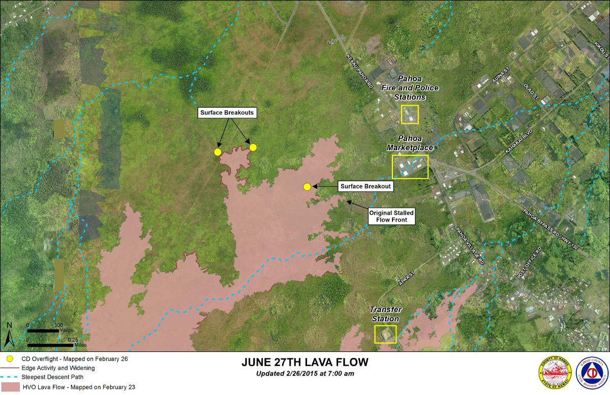
Civil Defense Lava Flow Map with Imagery – Updated Thursday, 2/26/15 at 7:00 am
PRIMARY SOURCES

This morning’s assessment continues to show no change with any of the down slope flow areas. Surface breakouts and breakouts along both margins upslope of the flow front continue and provide indication that the tube system continues to be supplied and lava from the source is making its way to the down slope areas. The breakout along the north margin remains active however sluggish and widening and no advancement was noted since Monday morning. The leading edge of this breakout is approximately 1 mile to the west or mauka of Highway 130. All current activity does not pose an immediate threat to area communities. The Hawaii County Civil Defense Agency and Hawaiian Volcano Observatory are maintaining close observations of the flow and residents and businesses down slope will be informed of any changes in flow activity and advancement.
Smoke conditions were light with a light southwest wind blowing the smoke in a northeast direction. Smoke conditions may increase in some areas and individuals who may be sensitive or have respiratory problems are advised to take necessary precautions and to remain indoors. There was no brush fire activity noted and fire conditions will be monitored closely.
On behalf of the Hawaii County Civil Defense Agency and our partners we would like to thank everyone for your assistance and cooperation. Hawaii County Civil Defense on Feb. 26 at 7:45 a.m. HST

Activity Summary: Kīlauea Volcano continues to erupt at its summit and from its East Rift Zone. The inactive distal tip of the June 27th lava flow remains roughly 500 m (~550 yd) from Highway 130 in the area west of the Pāhoa Fire and Police Stations. Breakouts continue in both the down slope and up slope flow areas. The breakout along the north margin of the stalled flow tip is still active but sluggish, and has not advanced since Monday. The leading edge of this flow is approximately 1.6 km (1 mile) up slope of Highway 130. Activity continues along the new breakout that started from the upper June 27th tube on the north flank of Puʻu ʻŌʻō. Tiltmeters located at the summit are recording inflationary tilt.
June 27th Lava Flow Observations: While the flow continues to widen, no advancement has been observed since Monday. The lobe on the south side of the flow, about 870 m (0.5 mi) up slope of Malama Market, is no longer advancing, but hosts a few active breakouts several hundred meters upslope of the stalled front. Activity is diminishing on the new breakout that started from the upper June 27th tube on the north flank of Puʻu ʻŌʻō. The breakout about 3 km (2 miles) northeast of Puʻu ʻŌʻō at the forest boundary remains active. Scattered activity also continues west of Kaohe Homesteads in the same general areas that have been active for about the last month, as well as in a slightly down slope area. Observers on a Civil Defense overflight this morning reported no change in any of the down slope flow areas.
Puʻu ʻŌʻō Observations: The tiltmeter on the north flank of Puʻu ʻŌʻō shows deflationary tilt. Minor lava flows within the crater of Puʻu ʻŌʻō have also been observed over the last 24 hours. The rate of sulfur dioxide emission from all East Rift Zone vents was about 200 tonnes per day, measured on January 7 (unfavorable wind and weather conditions have prevented more recent measurements).
Summit Observations: Tiltmeters operating around the summit began recording inflationary tilt beginning about 9 AM Wednesday, which has been accompanied by rising lava lake levels. Emission rates of sulfur dioxide were measured at 3,300 tonnes/day on February 13. The swarm of long period earthquakes within Kīlauea Caldera has mostly ceased since the start of inflationary tilt.USGS Hawaiian Volcano Observatory on Feb. 26 at 8:33 a.m. HST
THE LATEST: June 27 lava flow archive

by Big Island Video News
on at
STORY SUMMARY
NEWS BRIEFS The flow continues to widen, but no advancement has been observed since Monday. The breakout along the north margin remains active however it is sluggish, remaining 1 mile to the west or mauka of Highway 130. Activity is diminishing on the new breakout that started from the upper June 27th tube on the […]