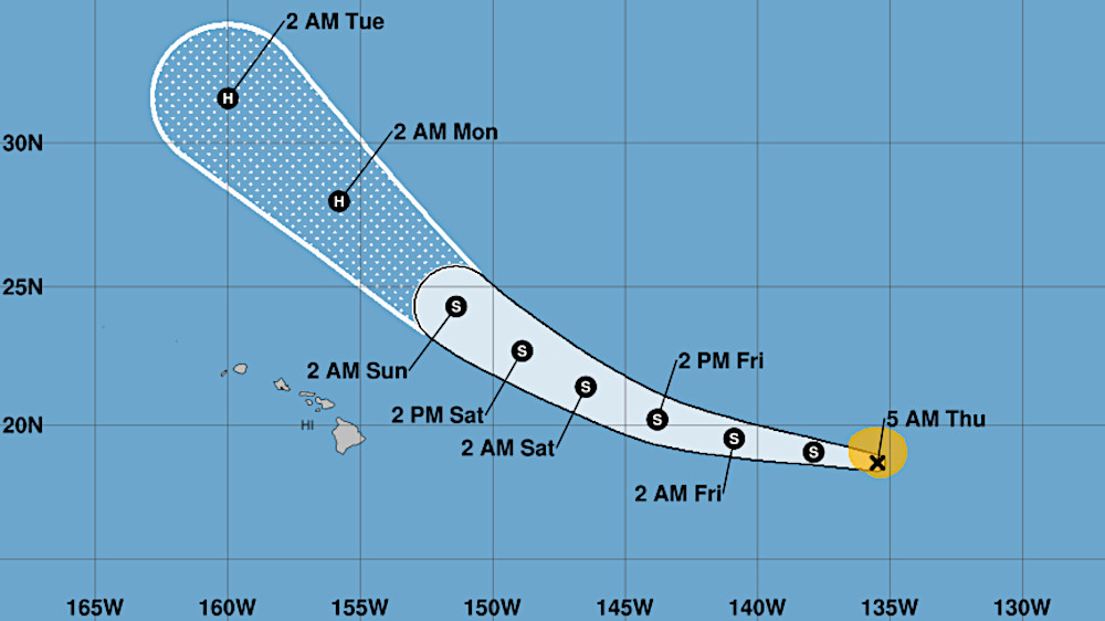
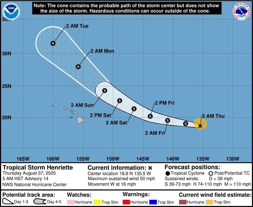
(BIVN) – Tropical Storm Henriette, located 1,280 miles east of Hilo on Thursday morning, is expected to become a hurricane as it passes to the north of the Hawaiian Islands.
Henriette is moving west at 16 mph. Maximum sustained winds are near 50 mph (85 km/h) with higher gusts. The National Hurricane Center says little change in strength is forecast during the next couple of days, followed by gradual intensification. It could become a hurricane as it makes a gradual turn toward the northwest Friday and over the weekend.
“Medium range global models and National Hurricane Center forecasts continue to show Tropical Storm Henriette passing just north of the islands from Sunday through Monday, once again disrupting trade winds, enhancing leeward and interior island shower activity, and producing warm and very humid weather,” the Honolulu-based National Weather Service office stated on Thursday. “Moderate trade winds with drier trends develop from late Monday onward, with more typical summer weather conditions lasting through the end of next week.”
From the National Hurricane Center discussion posted at 5 a.m. HST:
Henriette continues to hang in there despite straddling 25 C sea-surface temperatures. Since the prior advisory, a little more convection has redeveloped close to the estimated center, though overall the appearance of the tropical storm is still rather ragged looking. The current intensity estimate from TAFB has not changed for 12 UTC at 45 kt. In deference to this value and earlier scatterometer data, the initial intensity is being maintained at 45 kt this advisory.
The tropical storm continues to move westward, or 280 degrees at 14 kt. This general motion will continue through today, followed by a turn west-northwestward and then more northwestward due to the influence of a subtropical ridge to its north that will become gradually eroded by a large mid-oceanic trough amplifying over the North-Central Pacific in 2-3 days. The track guidance is essentially a carbon copy of the previous cycle, and only slight changes were made to the official track forecast. This forecast lies near the various multi-model consensus aids.
Henriette is already moving over cool ocean waters, which are expected to cool to 24C over the next 12-24 hours. While it would not be surprising to see a little more weakening over the short term, the storm has proven to be resilient thus far. Another environmental factor to consider is the upper-level temperatures, which are colder than normal due to a negatively tilted upper-level trough to the storm’s west. This trough might help to sustain some convection over what would ordinarily be waters too cool to allow such activity to persist. Once Henriette begins to move over warmer ocean waters again in the Central Pacific west of 150W, the other environmental factors are expected to remain favorable, and intensification is shown in the latter half of the forecast period. In fact, Henriette could become a hurricane in 96-120 h well to the north of Hawaii. The latest NHC intensity forecast is a little higher than the prior advisory, though there remain some guidance aids that are even higher than the NHC forecast at the end of the period (HAFS-B).

by Big Island Video News
on at
STORY SUMMARY
HAWAIʻI - The tropical cyclone is expected to turn toward the northwest Friday and over the weekend, keeping the center of the storm well to the north of the Hawaiian Islands.