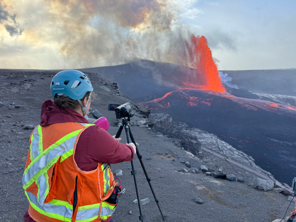
USGS: “A USGS Hawaiian Volcano Observatory geologist collects video of episode 36 lava fountaining from the south rim of the caldera at Kīlauea summit, on Sunday, November 9. Video data helps document activity and is used for later research on lava fountaining dynamics.” (USGS photo by M. Patrick)
(BIVN) – The federal government has reopened following the longest shutdown in United States history, and the USGS Hawaiian Volcano Observatory is once again posting photos to its website, including some featuring the high lava fountain episodes that occurred during the closure.
The federal government shutdown began on October 1, 2025, and lasted for 43 days. During that time, the USGS HVO continued to monitor Kīlauea volcano, and document the eruptive episodes that were occurring at the summit within Hawaiʻi Volcanoes National Park. Although USGS webcams continued to stream live video from the summit, and daily updates were provided, the Observatory was unable to share photos taken by scientists on the official website.
On November 13, after U.S. Congress agreed on a measure that would reopen the government, some of those Observatory photos began to appear online.
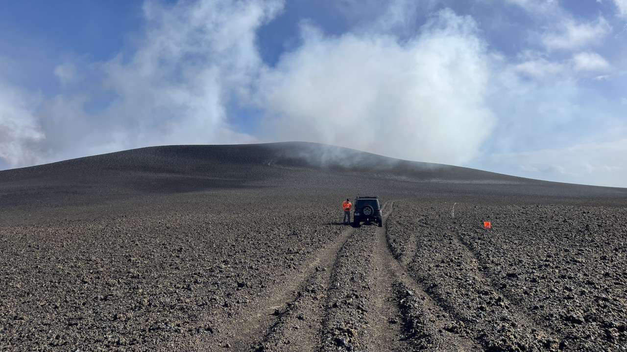
USGS: “The day after episode 36 of the ongoing Kīlauea eruption, USGS geologists inspected the tephra deposit west of Halema‘uma‘u, in the closed area of Hawai‘i Volcanoes National Park. This photo looks south, with Halema‘uma‘u out of view to the left. Tephra from the lava fountains continues to accumulate and since December 2024 has built up a hill that is more than 140 ft (42 m) high, covering Crater Rim Drive. During episode 36, which lasted only five hours, the hill grew by an estimated 30 ft (9 m).” (USGS photo by N. Deligne)
The current eruption, which began in December 2024, has now lasted over 10 months. “Recent episodes featured the highest lava fountains, the most volume of lava erupted, and the highest rate of lava effusion for this event,” the Observatory recently noted.
“These recent episodes added tephra to the growing cone on the rim of Halemaʻumaʻu crater, with about 30 feet (9 meters) added during episode 36 alone,” the USGS HVO wrote. “In total, the new cone has grown to about 138 feet (42 meters) above the pre-eruption ground surface on the crater rim.”
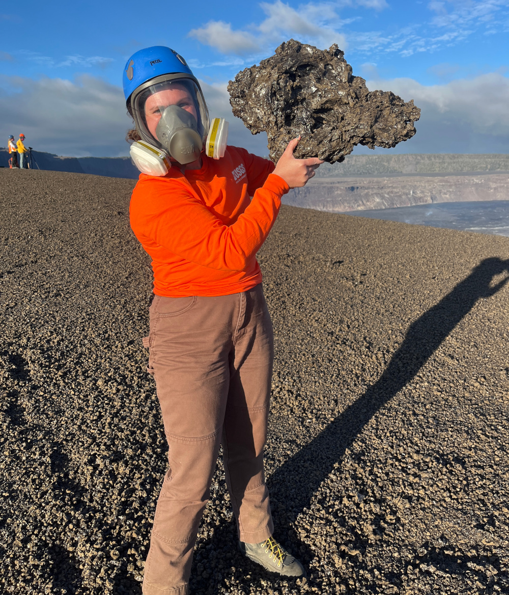
USGS: “During the lava fountains of episode 33 on September 19, tephra particles traveled through the air and fell downwind west of Halema‘uma‘u. This clast was about 16 inches (40 centimeters) long, very lightweight due to being very bubble-rich, and delicate.” (USGS photo by N. Deligne)
The preliminary forecast for the next high lava fountains (Episode 37) is as early as November 22. The USGS Volcano Alert Level remains at WATCH.

by Big Island Video News
on at
STORY SUMMARY
HAWAIʻI VOLCANOES NATIONAL PARK - Scientists are once again able to share photos of the eruption, taken from within the closed area of the park.