Scientists keeping an eye on large lobe on the pali
Kalapana, Hawaii – photos, maps courtesy USGS
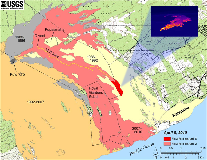
A fresh lava flow from the Pu’u ‘O’o eruption has advanced about a mile since last Friday, and geologists believe if it continues on its current path, it will rejoin the older flow field on the coastal plain just west of the current viewing area.
However, scientists warn it is possible that the lava will advance farther east before descending toward the coast.
The Hawaiian Volcano Observatory has been issuing daily reports on the Kilauea volcano, as is normal for the scientists under the United States Geological Survey. They say the new surface flows are fed by lava tubes, and that they are advancing slowly to the southeast down the Pulama pali, east of the Royal Gardens subdivision, as indicated by field observations and GOES satellite imagery.
Last year, a surface flow following a similar path rolled down the pali and scorched the kipukas that surround the county’s lava viewing area. The lava even covered part of an older access road by the tourist hotspot.
There has been no ocean entry to wow spectators over the last few months, so certainly the tourism industry awaits the new flow anxiously. However, a recent DI event on the north flank of Pu’u ‘O’o may end up stalling the new surface flow.

According to the USGS, this map shows the extent of the July 21, 2007 eruption flow field relative to surrounding communities. Light red is the area of the flow as of April 2, 2010, while the bright red shows the flow field expansion mapped by HVO geologists between April 2 and April 8. Flows erupted earlier during the 1983-present Puu Oo - Kupaianaha eruption are shown in more muted colors and labeled with the years in which they were active. The inset thermal image, also courtesy the USGS, highlights the active flow area clearly. The active flows are traveling down the east margin of the Thanksgiving Eve Breakout (TEB) flow field.

by Big Island Video News2:01 pm
on at
STORY SUMMARY
Scientists keeping an eye on large lobe on the pali Kalapana, Hawaii – photos, maps courtesy USGS A fresh lava flow from the Pu’u ‘O’o eruption has advanced about a mile since last Friday, and geologists believe if it continues on its current path, it will rejoin the older flow field on the coastal plain […]