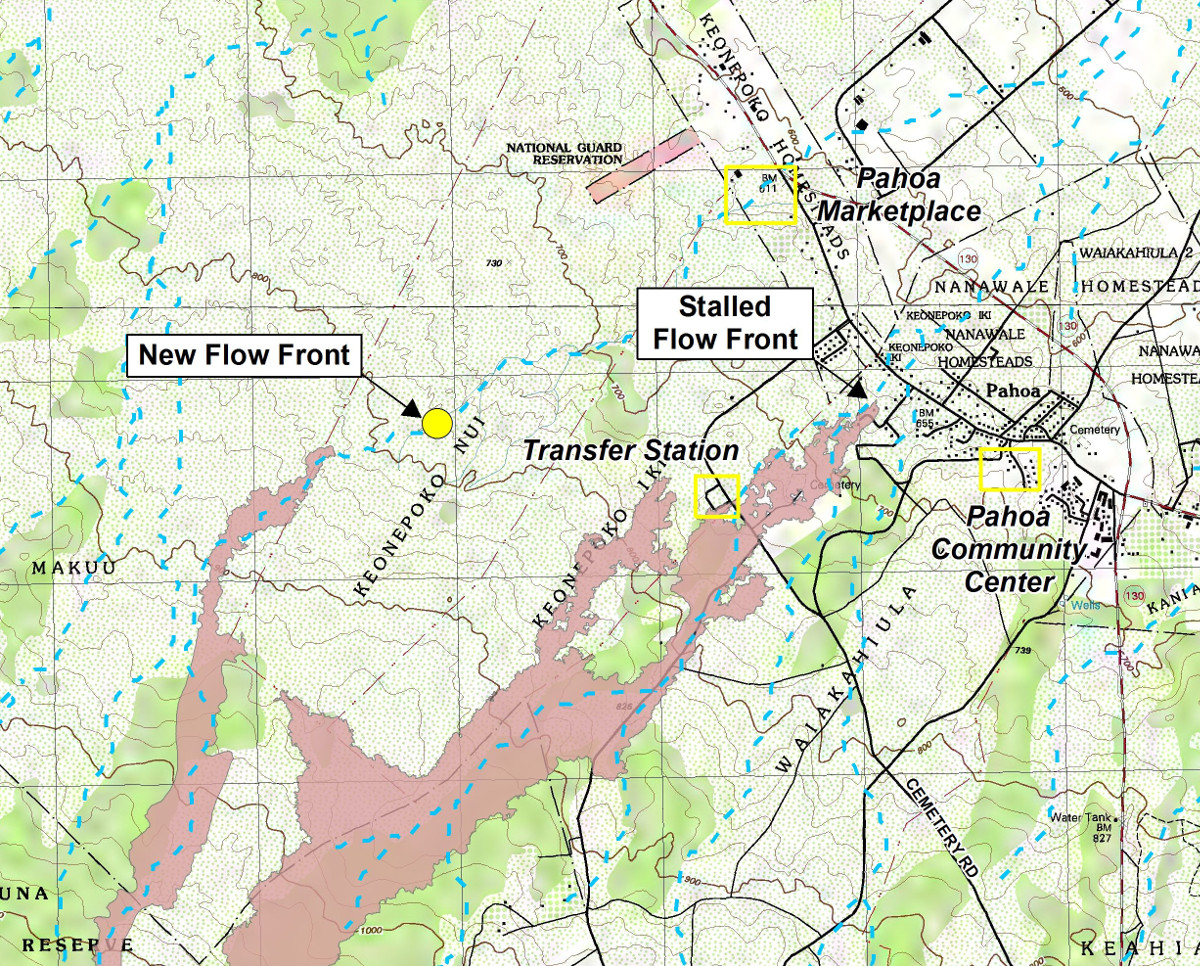
(ABOVE MAP) Inset of today’s Civil Defense Lava Flow Map, Updated Sunday, 12/14/14 at 7:00 am
NEWS BRIEFS
- The active flow has advanced approximately 300 yards since yesterday and is 1.4 miles upslope of the Highway 130 and Pahoa Village Road intersection.
INSIGHT
Here is today’s civil defense audio message:
PRIMARY SOURCES

This morning’s assessment shows that the flow front remains active and continues to advance in an east-northeast direction. The active flow had advanced approximately 300 yards since yesterday and the front remains approximately 1.4 miles upslope of the Highway 130 and Pahoa Village Road intersection. Current activity does not pose an immediate threat to area communities and Civil Defense and Hawaiian Volcano Observatory personnel are maintaining close observations of flow activity. Residents and businesses down slope will be kept informed of any changes in flow activity, advancement, and status.
Smoke conditions were light this morning in the immediate area with a light north wind blowing the smoke in a south southeast direction. Smoke conditions may increase in some areas and residents that may be sensitive or have respiratory problems are advised to take precautions and to remain indoors.
The Pahoa Village Road remains open to all traffic and motorists are advised to exercise caution as some utility pole protection material remains in place. Everyone is asked to please respect the residents of the area who were affected by the lava flow and to not trespass on private property.
Additional updates will be broadcast as conditions change.
Once again we would like to thank everyone for your patience and understanding and your cooperation and assistance is greatly appreciated. Hawaii County Civil Defense on Dec. 14 at 8:15 a.m. HST
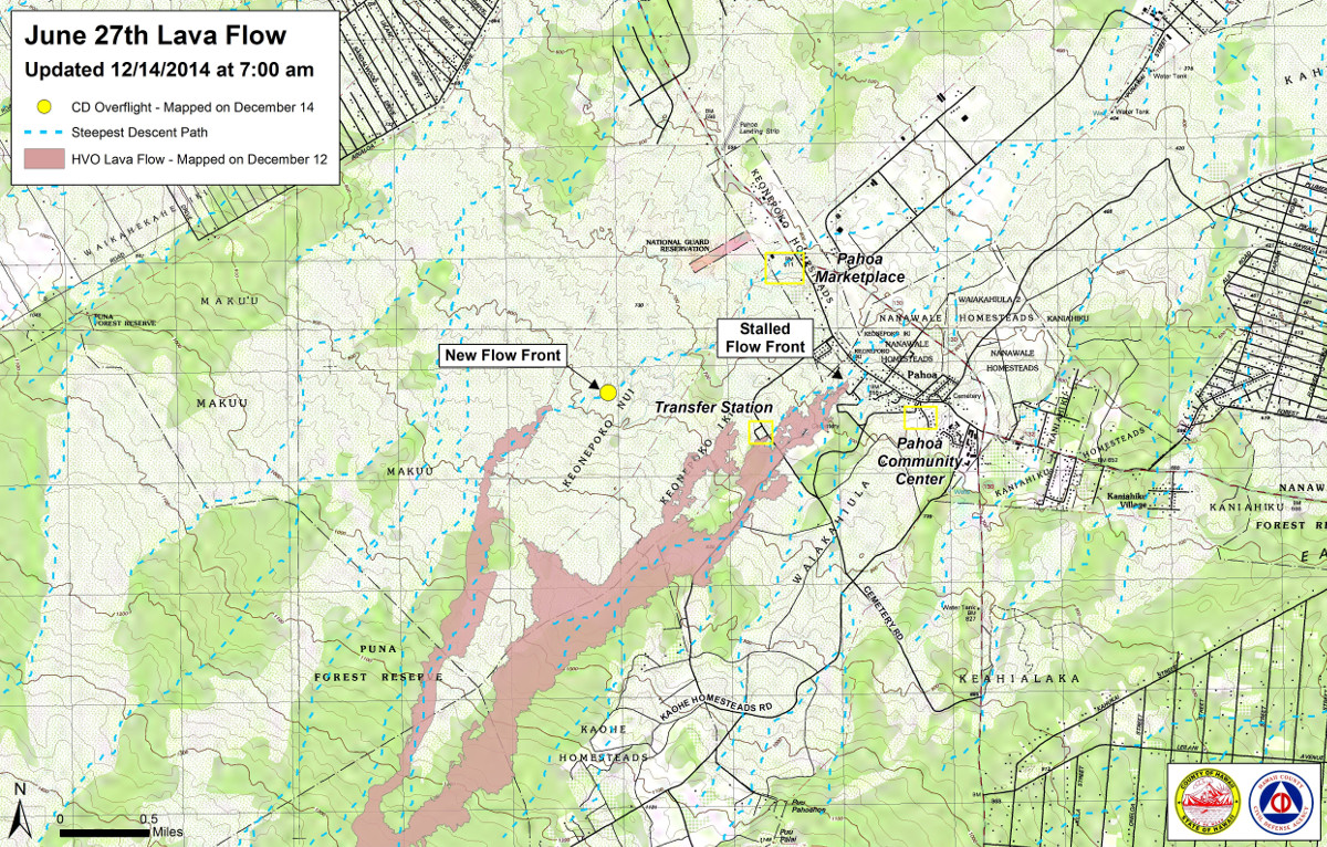

Kīlauea Volcano continues to erupt at its summit and within its East Rift Zone. A narrow lobe of lava west of the flow field below the crack system remains active and advanced ~275 m (~300 yds) since yesterday. The leading edge of this lobe is approximately 2.25 km (1.4 miles) above the intersection of Pāhoa Village Road and Highway 130, near the Pāhoa Marketplace. After a slight increase in tilt, Kīlauea’s summit began a deflationary tilt trend starting at 2 AM last night.
June 27th Lava Flow Observations: HVO, along with Civil Defense, is monitoring a narrow flow lobe that branches off the west edge of the flow field below the crack system. Civil Defense reported, this morning, that the leading edge of the flow was about 2.25 km (1.4 mi) upslope from the intersection of Pāhoa Village Road and Highway 130, near the Pāhoa Marketplace. The active lobe is following a steepest-descent path that takes the flow towards the intersection of Pāhoa Village Road and Highway 130, in the vicinity of the Pāhoa Marketplace. In addition to this active lobe, a breakout from the lava tube on December 5, about 2.6 km (1.6 mi) from Puʻu ʻŌʻō remains weakly active. The breakout is about 1 km (0.6 mi) long, and has widened the flow field in this area by about 200 m (220 yd).
Puʻu ʻŌʻō Observations: Tilt trend at Puʻu ʻŌʻō is essentially flat or no marked change. All other monitoring data indicate no significant changes at Puʻu ʻŌʻō. Seismic tremor is low and steady, and webcams revealed no strong variations in the pattern of glow from degassing vents or the configuration of the crater floor. GPS-measured deformation across the cone has shown no net extension nor contraction since July. The most recent measurement of sulfur dioxide emissions from the East Rift Zone was about 250 tonnes per day on November 26, 2014.
Summit Observations: After a slight increase in tilt, deflationary tilt has begun as of 2 AM last night. The summit lava lake showed the usual fluctuations associated with changes in spattering behavior, which are also manifested as variations in tremor amplitudes. Small amounts of particulate material were carried aloft by the plume. The average emission rate of sulfur dioxide was 4,100 tonnes/day for the week ending on December 9USGS Hawaiian Volcano Observatory on Dec. 14 at 8:55 a.m. HST