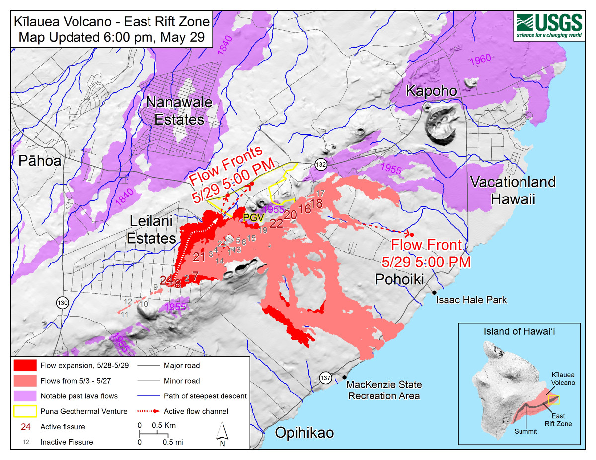
USGS: Map as of 6:00 p.m. HST, May 29, 2018. Given the dynamic nature of Kīlauea’s lower East Rift Zone eruption, with changing vent locations, fissures starting and stopping, and varying rates of lava effusion, map details shown here are accurate as of the date/time noted—and could have changed rapidly since that time. Shaded purple areas indicate lava flows erupted in 1840, 1955, 1960, and 2014-2015.
(BIVN) – USGS Hawaiian Volcano Observatory deputy scientist-in-charge Steve Brantley gave a short presentation Tuesday on the ongoing eruption in the lower East Rift Zone of Kilauea.
Before Brantley spoke to the crowd at the Pahoa High School cafeteria, lava covered Highway 132, and Fissure 8 in Leilani Estates had been producing high fountains.
Here is the latest update from USGS Hawaiian Volcano Observatory at 10 p.m. HST:
Vigorous eruption of lava continues from the lower East Rift Zone (LERZ) fissure system in the area of Leilani Estates and Lanipuna Gardens.
Fissure 8 remained very active Tuesday afternoon and evening, fountaining to heights of 200 feet at times and feeding a lava flow that advanced atop an existing flow (which was emplaced on Sunday night/Monday morning). After a finger of lava crossed Highway 132 earlier this afternoon near the PGV access road, the bulk of the lava remained on the south side of the highway, roughly paralleling the highway as it moved downslope.
Visual observations early Tuesday afternoon also confirmed continued weak activity at Fissures 18 and 16. Fissure 18 is producing channelized flows which had advanced to within 0.9 miles of the coast as of 7:10 PM HST. On Tuesday evening, Hawaii County Civil Defense began providing preliminary warnings to residents in the area to be prepared to evacuate if the flow continues to advance and threatens to cut Highway 137.
Pele’s hair and and other lightweight volcanic glass from high fountaining of Fissure 8 are being transported downwind and falling to the west of the fissure. On Monday night, there were reports of Pele’s hair falling in Pāhoa. Residents are urged to minimize exposure to these volcanic particles, which can cause skin and eye irritation similar to volcanic ash.
The most recent map of lava flows can be found here.
HVO field crews are on site tracking the fountains, lava flows, and spattering from multiple fissures as conditions allow and reporting information to Hawaii County Civil Defense. Crews are also checking on the status of ground cracks on Highway 130.
Volcanic gas emissions remain very high from the fissure eruptions. Trade winds are forecast to return in the coming days, meaning that vog may impact the southern and western sides of the island.
Magma continues to be supplied to the lower East Rift Zone. Earthquake locations have not moved farther downrift in the past few days and the number of located earthquakes remains low.

by Big Island Video News
on at
STORY SUMMARY
PAHOA, Hawaii - USGS Hawaiian Volcano Observatory scientist Steve Brantley gave a short update during the public meeting in Pahoa on Tuesday night.