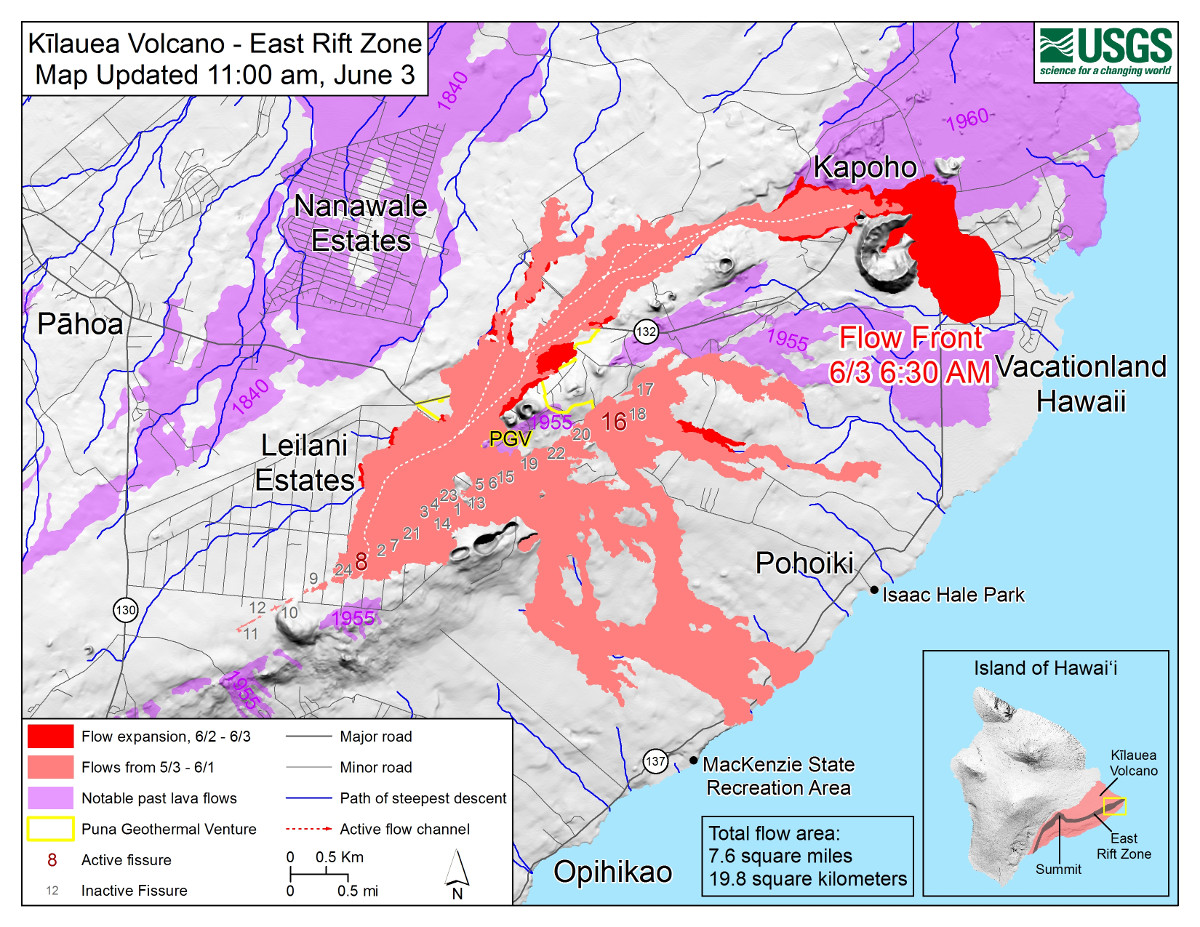
USGS MAP: Map as of 11:00 a.m. HST, June 3, 2018. Given the dynamic nature of Kīlauea’s lower East Rift Zone eruption, with changing vent locations, fissures starting and stopping, and varying rates of lava effusion, map details shown here are accurate as of the date/time noted. Shaded purple areas indicate lava flows erupted in 1840, 1955, 1960, and 2014-2015.
(BIVN) – Video recorded by Mick Kalber from a helicopter over the Kapoho lava flow Sunday morning shows the wide flow front moving slowly towards Kapoho Beach Lots, and possibly Vacationland, “or more likely, both,” Kalber remarked.
Kalber noted the changes he observed since yesterday’s overflight:
The flow front has now covered Four Corners… an intersection that effectively cuts off residents between Pohoiki Road and Green Mountain, including Pohoiki, The Hot Pond area, Vacationland, and Kapoho Beach Lots from the rest of the island. But in addition to making the intersection and a large portion of Highway 137 (The Red Road) to the south, she made a u-turn, destroyed a home there and entered Green Mountain! She entered Green Lake and sent a plume skyward, and is now burning houses in the agricultural area across the street.
Hawaii County Civil Defense Message issued the following message on Sunday, June 3 at 12:30 in the afternoon:
Hawaiian Volcano Observatory reports active lava eruptions continue. Fissure 8, located in the Leilani Estates area, continues to feed a large channelized flow traveling downslope through Kapoho Beach Lots. The wide flow front is about 400 yards from the ocean.
Due to lava crossing Highway 137 and approaching the ocean, the following policies are in effect:
There is no access to Kapoho, Vacationland, Highway 132, and Highway 137.
First responders are conducting search and rescue missions in affected isolated areas today.
Be aware of the laze hazard should lava hit the ocean and stay away from any ocean plume to prevent harmful health effects.
On roadways:
Government Beach Road, between Kahakai Boulevard and Papaya Farms Road, is open to Waa Waa and Papaya Farms Road residents only with official credentials. There is no curfew.
Due to the volcanic activity, the following is provided for your information:
Volcanic gas and ash emissions remain high at the Kilauea summit and in the fissure system.
Pele’s hair and volcanic glass can be carried by the wind.
Residents on the south and west sides of the island should take action to limit exposure to gas, ash, and volcanic particles.
Stay alert to warnings from Civil Defense officials and be prepared to evacuate with little notice.

by Big Island Video News
on at
STORY SUMMARY
PUNA, Hawaii - There is no access to Kapoho, Vacationland, Highway 132, and Highway 137. First responders are conducting search and rescue missions in affected isolated areas.