(BIVN) – The USGS Hawaiian Volcano Observatory on Wednesday issued a Kīlauea Information Statement on the swarm of deep earthquakes occurring below Pahala under the volcano’s Southwest Rift Zone.
The statement has not altered the volcano alert level for Kīlauea, which remains at NORMAL / GREEN. Kīlauea is not erupting, and the scientists say the deep earthquake activity does not mean an eruption is imminent.
The Information Statement reads:
SUMMARY
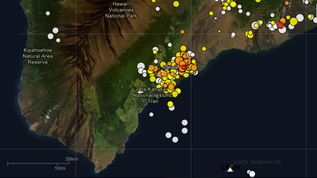
Since August 2019, the US Geological Survey Hawaiian Volcano Observatory (HVO) has recorded over 5,900 earthquakes beneath Kīlauea’s lower Southwest Rift Zone in a cluster about 6 mi (10 km) wide near the town of Pāhala. These earthquakes are occurring 15-25 mi (25-40 km) below the surface.
Deep earthquakes of this type do not generally pose a hazard from ground-shaking. Most earthquakes in the sequence have been magnitude-2 or lower, and most have not been felt by residents.
Clustering of deep earthquakes in this region does not mean an eruption is imminent. HVO has recorded earthquakes in this area for many decades across several eruptive cycles at both Kīlauea and Mauna Loa volcanoes. No correlation between seismic activity in this zone and volcanic activity at the surface has been established, although this is an important topic for future research.
BACKGROUND
Past studies suggest these earthquakes, and associated episodes of rhythmic ground shaking known as tremor, are the result of stresses caused by transport of magma through the Earth’s mantle deep beneath the island, an area that may be the source region supplying magma to the active volcanoes.
The HVO monitoring network has recorded a high rate of seismicity in this region, typically between 20-40 earthquakes per day, since August 2019. A peak rate of more than 80 per day was recorded in February 2020. These rates are the highest ever measured for the area in the 60 years of instrumental observation. A sustained increase of this deep seismicity above long term background levels began as early as November 2015, although at rates lower than currently observed.
The strongest earthquake recorded in this sequence since August 2019 was a magnitude-3.5 event on January 6, 2020. The largest ever recorded by HVO in this deep region was a magnitude-4.7 earthquake in January 2006. Earthquakes in the magnitude 3-4 range can be felt widely by residents and are reported as weak to light shaking.
HVO continues to monitor the volcanoes of Hawaii including daily analysis of ongoing Pāhala area seismicity. We will provide additional updates on any significant change in volcano status.
For more information on deep earthquakes in the Pāhala area, please see the Volcano Watch article titled, “Why do so many deep earthquakes happen around Pāhala?” published by HVO scientists on October 10, 2019.