(BIVN) – Hurricane Kiko has become a major hurricane.
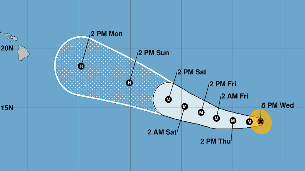
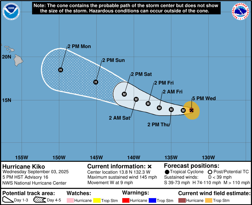
Kiko is a category 4 hurricane on the Saffir-Simpson Hurricane Wind Scale, moving west towards the Central Pacific at 9 mph. Kiko was 1,560 miles east southeast of Hilo as of Wednesday evening.
The storm’s maximum sustained winds have increased to near 145 mph (230 km/h) with higher gusts. Little change in strength is forecast through Friday, the National Hurricane Center says, followed by gradual weakening over the weekend as Kiko approaches the Hawaiian Islands from the east.
“The track of this cyclone will be governed by its intensity and interaction with steering flow, the latter of which will be modulated in part by deepening mid-latitude troughing near the islands as it approaches,” the National Weather Service in Honolulu wrote on Wednesday evening. “A flash flood threat may develop over the islands in the Tuesday-Thursday time frame conditional on the exact track of the system.”
From the 5 p.m. National Hurricane Center discussion:
Kiko remains a powerful category 4 hurricane, with satellite images showing a well-defined eye surrounded by a very cold ring of deep convection with cloud top temperatures of -70 to -85C. The most recent subjective Dvorak current intensity estimates from TAFB and SAB were 6.0/115 kt and 6.5/127 kt respectively, while the objective estimates from UW-CIMSS have ranged between 119 and 132 kt during the past several hours. Based on a blend of these data, the initial intensity has been raised to 125 kt for this advisory.
Kiko is moving just south of due west, or 265 degrees, at 8 kt. This general westward motion is expected to continue through Thursday night, as the cyclone is steered by a building subtropical ridge to its north and northwest. A turn toward the west-northwest is forecast on Friday as an upper-level trough north of Hawaii begins to erode the western portion of the subtropical ridge, with this general motion then continuing through the weekend with a gradual increase in forward speed. There remains some along-track and cross track spread among the global models, although the spread has decreased considerably during the past 24 hours. The official track forecast remains in good agreement with a blend of the latest multi-model consensus aids and is nearly on top of, but slightly slower than, the previous forecast track.
Kiko will remain over warm waters of 27–28C and influenced by mostly light vertical wind shear through around 60 to 72 hours. The surrounding environmental mid-level moisture will remain drier than optimal, hovering between 50 and 60 percent during the next couple of days, before dropping below 50 percent by day 3. Despite the somewhat dry mid-level airmass, the light vertical wind shear and warm sea surface temperatures should maintain Kiko as a major hurricane through day 3. There will likely be some fluctuations in strength during the next several days with the potential for eyewall replacement cycles during this time. By days 4 and 5, the cyclone will begin moving over cooler water with gradually increasing westerly vertical wind shear, and mid-level moisture plummeting below 40 percent. These factors should lead to steady and eventually rapid weakening of Kiko as the cyclone approaches the Hawaiian Islands from the east. Kiko will be influenced by environmental factors that can lead to the development of annular characteristics along its approach, which can slow the rate of weakening. As a result, the official intensity forecast remains on the higher end or slightly above the intensity aids through day 5, and is very close to the previous advisory.

by Big Island Video News
on at
STORY SUMMARY
HAWAIʻI - Kiko is a category 4 hurricane on the Saffir-Simpson Hurricane Wind Scale, but is expected to weaken before it approaches the Hawaiian Islands from the east.