
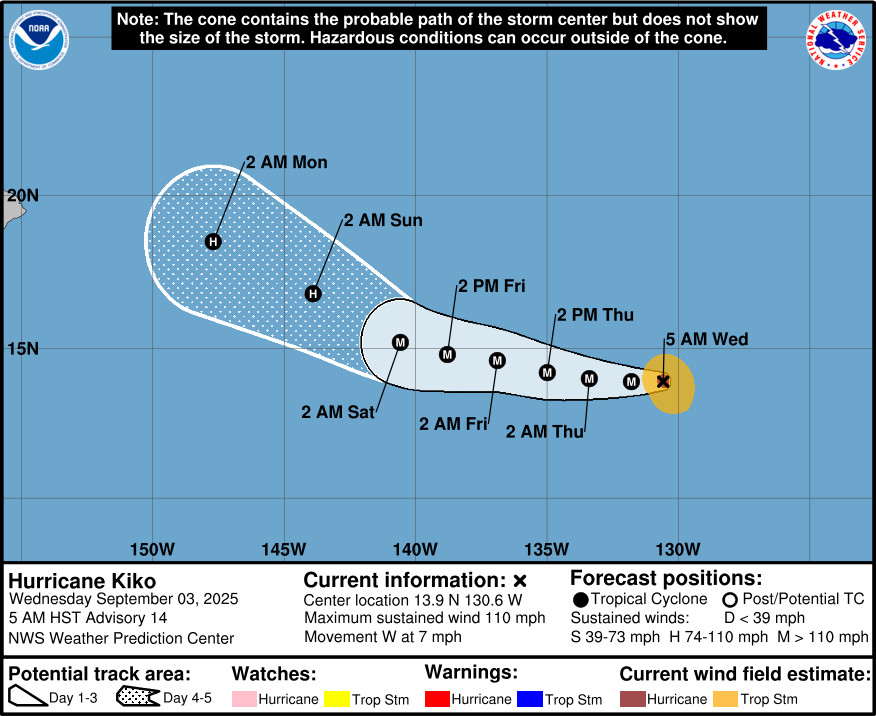
(BIVN) – Hurricane Kiko was 1,665 miles east of Hilo on Wednesday morning, moving west at 7 mph.
Kiko’s maximum sustained winds have increased to near 110 mph (175 km/h) with higher gusts, and the storm is expected to strengthen more during the next 48 hours. Kiko should become a major hurricane later today.
“Heading into the middle of next week, forecast uncertainty increases due to the passage of Hurricane Kiko over the region,” the National Weather Service in Honolulu wrote on Wednesday morning. “Given uncertainty at this time, it remains too early to tell what, if any, impacts this system will have on local weather.”
As of now, extended forecasts show Kiko is likely to weaken before it nears Hawaiian waters.
From the National Hurricane Center discussion posted at 5 a.m. HST:
Kiko is getting better organized on satellite with an eye clearing out over the past 6 to 12 hours with recent satellite images showing the eye being surrounded by a ring of deep convection. The most recent subjective Dvorak current intensity estimates from TAFB and SAB were both 5.0/90 kt at 12Z but since that time the structure has improved on satellite while the objective ADT estimate was 99 knots. The initial intensity has been set at 95 kt as a compromise between these estimates.
Kiko is moving due west, or 270 degrees, at 7 kt. This general motion is expected to continue during the next couple of days, as the cyclone is steered by a building subtropical ridge to its north and northwest. A turn toward the west-northwest is forecast by day 3 as an upper-level trough north of Hawaii erodes the western portion of the subtropical ridge, with this general motion then continuing through day 5. The track guidance this cycle was tightly clustered through day 3. After that time, the European ensemble shows a significant increase in spread in both the along- and cross-track directions. The official track forecast remains close to the HCCA and GDMI model solutions and is on the southern side of the overall model envelope of solutions.
Kiko will remain over warm water and light vertical wind shear for at least the next 3 days. Kiko’s intensity will therefore likely be governed by inner-core structural changes. Given its current single eye-wall structure seen on earlier AMSR-2 microwave imagery, Kiko appears poised to intensify more in the short term and the latest intensity forecast shows more intensification than the previous advisory. This intensity forecast is on the higher end of the guidance suite closest to the HAFS-A and HAFS-B forecast over the next 2 to 3 days. After that time, cooler SSTs and an increase in southwesterly vertical wind shear should lead to gradual weakening.

by Big Island Video News
on at
STORY SUMMARY
HAWAIʻI - With maximum sustained winds near 110 mph, Kiko is expected to become a major hurricane later today.