(BIVN) – On February 15, lava fountains erupted at the summit of Kīlauea for nearly 10 hours. The event was the 42nd episode in the ongoing eruption of the Hawaiʻi island volcano.
The USGS Hawaiian Volcano Observatory has published new maps showing the lava flow and tephra accumulation during the episode, as well as ground deformation that occurred the week of the event.
During episode 42, a volume of 15 million cubic yards (11.4 million m³) of lava was erupted from the north and south vents at the summit caldera within Hawaiʻi Volcanoes National Park. Light tephra – fine ash & Pele’s hair – was reported in the communities downwind, to the southwest of the summit.

USGS: “Long strands of Pele’s hair, which is made of volcanic glass, drifted on the wind to the southwest during episode 42 of Kīlauea summit lava fountaining on February 15, 2026. This photo shows a bundle of these long strands of Pele’s hair after they had blown around in the wind in the community of Pāhala and became tangled up.” (USGS photo by D. Downs)
On Thursday, the USGS Hawaiian Volcano Observatory posted the following maps using data collected in the days before, during, and immidiately after episode 42.
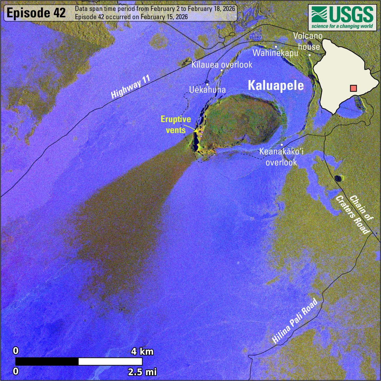
USGS: “This map shows lava flow and tephra accumulation at the summit of Kīlauea volcano associated with episode 42 of the ongoing eruption in Halemaʻumaʻu that started on December 23, 2024, using data recorded by the Italian Space Agency’s (ASI) COSMO-SkyMed Second Generation satellite constellation. These maps combine cross-polarized radar amplitude images taken on two different dates (on February 2 and 18, 2026), along with interferometric coherence from the time between those dates. In the maps, unchanged barren areas are represented in blue/purple, vegetated areas appear in yellow/light green, and new deposits over barren land are shown in dark green. These new deposits were formed on February 15, 2026, during episode 42 of the eruption. Public viewing areas within Hawaiʻi Volcanoes National Park are indicated with white squares; these can be temporarily closed for public safety.”
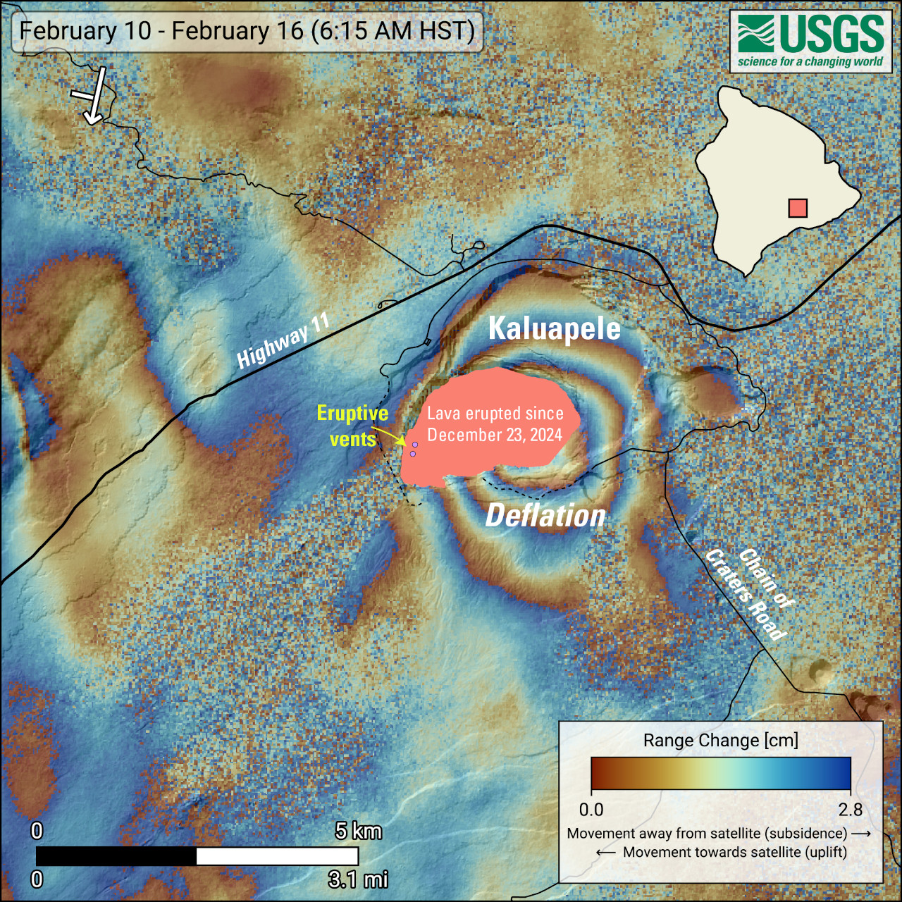
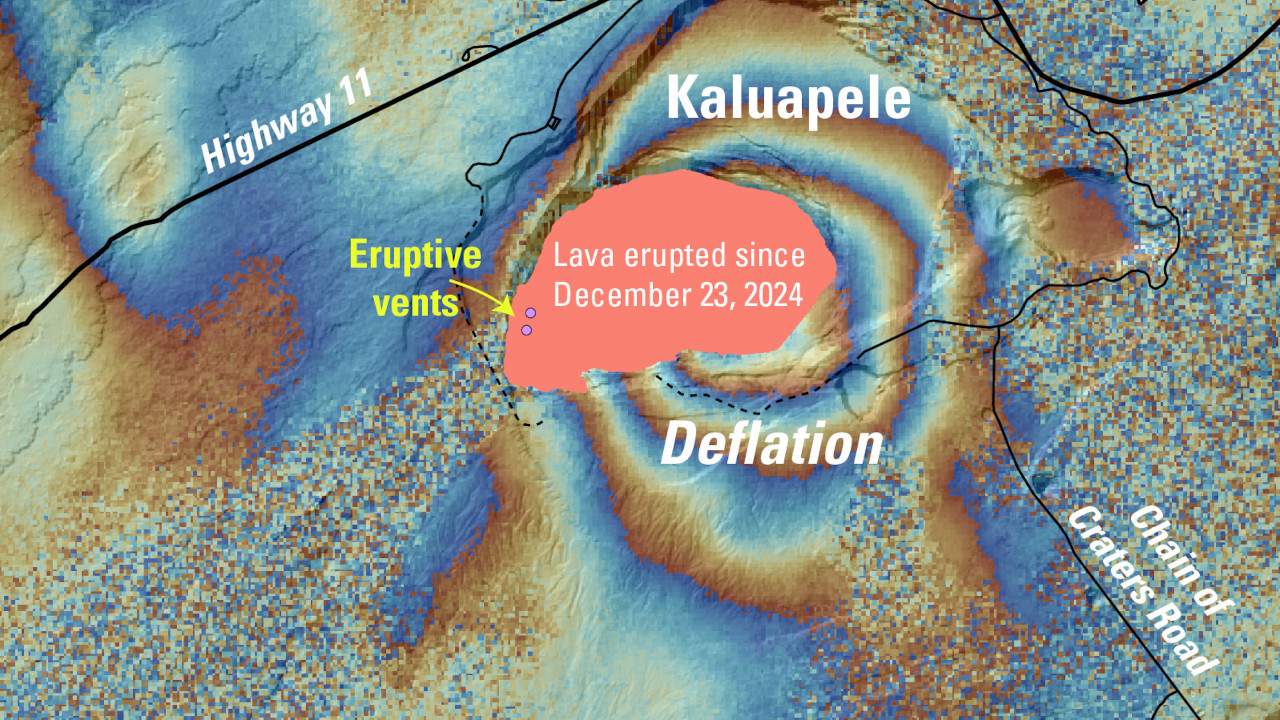
USGS: “This map shows recent deformation at Kīlauea, over the timeframe of February 10–16, 2026. Data were acquired by the European Space Agency’s Sentinel-1A/C satellites. Each color cycle represents 2.8 cm (1.1 in) of ground movement in the direction between the satellite and the ground (range change). The symbol in the upper left indicates the satellite’s orbit direction (arrow) and look direction (bar). The lava flows covering the crater floor are represented by the pink polygon, the two vents (circles) are marked in purple. This radar interferogram spanning episode 42 shows round fringes within and around Kaluapele (Kīlauea summit caldera) indicating ground surface deflation over the time period spanned by the images as magma was withdrawn from the Halemaʻumaʻu magma chamber at a depth of approximately 1.5 kilometers (1 mile) below the ground surface.”
The USGS HVO reported Thursday that preliminary models “suggest the likely forecast window for the onset of episode 43 lava fountaining is March 5-20, however inflationary tilt is needed to refine and narrow the forecast window.” The scientists noted the deformation recorded at summit tiltmeters has been relatively flat over the past 24 hours.
The USGS Volcano Alert Level for Kīlauea remains at WATCH.

by Big Island Video News
on at
STORY SUMMARY
HAWAIʻI VOLCANOES NATIONAL PARK - The new maps show lava flow, deformation, and tephra accumulation during eruptive episode 42.