Big Island Video News

Serving Hawaii County

  • Hawaiʻi Island News Regions
    • Hamakua
      • Mauna Kea
    • Hilo
    • Kau
    • Kona
    • Kohala
    • Puna
VIDEO: Tracking Kahauale’a 2 lava flow on Hawaii Island
Avatar photo

by Big Island Video News
on Jan 27, 2014 at 8:53 am

Subscribe to Big Island Video News (FREE)

* indicates required

STORY SUMMARY

Watch this video if you live in Puna subdivisions like HPP, Hawaiian Acres, or Ainaloa.

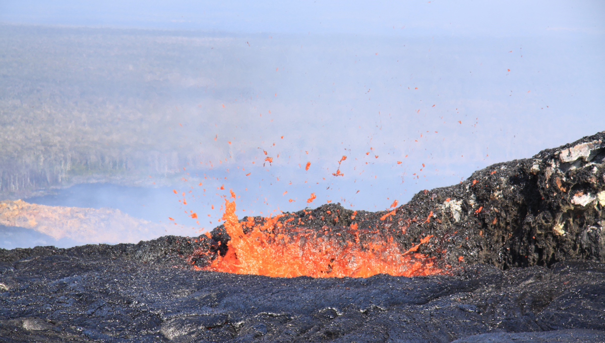
HAWAII VOLCANOES NATIONAL PARK, Hawaii – Scientists are keeping an eye on an active lava flow that has crawled nearly 5 miles from Pu’u O’o crater.

Its a slow lava flow, moving a mere 100 feet a day. But unlike the majority of the lava flows associated with the 31 year eruption on the volcanic East Rift Zone, this flow is going towards the northeast. Usually, the lava heads south, downhill towards the ocean. That means this lava is slowly heading towards populated Puna mauka subdivisions.

USGS HVO map: Map showing the Kahaualeʻa 2 flow in relation to the eastern part of the Big Island as of January 24, 2014. The front of the Kahaualeʻa 2 flow was 7.8 km (4.8 miles) northeast of Puʻu ʻŌʻō last week. These fingers stalled during a prolonged deflation–inflation cycle (DI event) at Kīlauea’s summit which started on January 17 and appears to be just finishing today (January 24). Lava flows have since resumed but are active closer to Puʻu ʻŌʻō, with the focus of activity about 5.6 km (3.5 miles) from the vent. The area of the Kahaualeʻa 2 flow as of January 10 is shown in pink, while widening of the flow as of January 24 is shown in red. Older lava flows are distinguished by color: episodes 1–48b flows (1983–1986) are shown in gray; episodes 48c–49 flows (1986–1992) are pale yellow; episodes 50–55 flows (1992–2007) are tan; episodes 58–60 flows (2007–2011) are pale orange, and episode 61 flows (2011–2013) are reddish orange. The active lava tube is shown with a yellow line.

USGS HVO map: Map showing the Kahaualeʻa 2 flow in relation to the eastern part of the Big Island as of January 24, 2014. The front of the Kahaualeʻa 2 flow was 7.8 km (4.8 miles) northeast of Puʻu ʻŌʻō last week. These fingers stalled during a prolonged deflation–inflation cycle (DI event) at Kīlauea’s summit which started on January 17 and appears to be just finishing today (January 24). Lava flows have since resumed but are active closer to Puʻu ʻŌʻō, with the focus of activity about 5.6 km (3.5 miles) from the vent. The area of the Kahaualeʻa 2 flow as of January 10 is shown in pink, while widening of the flow as of January 24 is shown in red. Older lava flows are distinguished by color: episodes 1–48b flows (1983–1986) are shown in gray; episodes 48c–49 flows (1986–1992) are pale yellow; episodes 50–55 flows (1992–2007) are tan; episodes 58–60 flows (2007–2011) are pale orange, and episode 61 flows (2011–2013) are reddish orange. The active lava tube is shown with a yellow line.

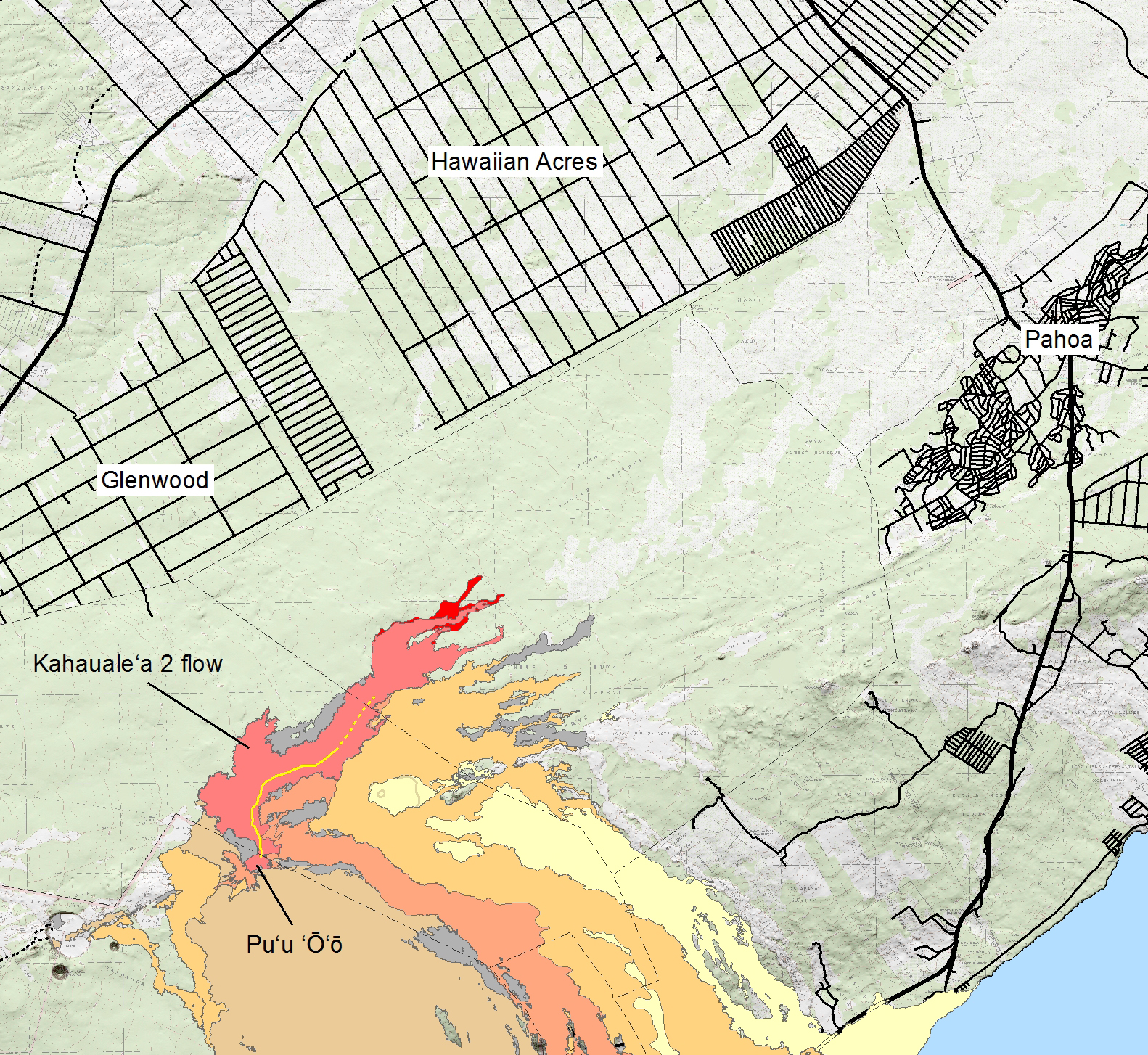
The US Geological Survey’s Hawaiian Volcano Observatory says there is no need for alarm right now, but they have been running the data on possible scenarios. Some of those findings were discussed at the recent After Dark in the Park talk at the Hawaii Volcanoes National Park.

In our feature story, geologist Tim Orr describes the latest lava flow, called Kahaule’a 2.

Orr’s message was repeated in a recent Volcano Watch article, written weekly by the scientists at the HVO.

Unless there is a significant change at Puʻu ʻŌʻō, the Kahaualeʻa flow poses no imminent threat to infrastructure, but will likely continue advancing toward the northeast, burning forest as it does. It could eventually reach communities far downslope, but fortunately, the East Rift Zone eruptive output remains weak. At its current pace, the Kahaualeʻa flow would take more than a year to reach populated areas.USGS HVO Volcano Watch article, January 2, 2014

USGS HVO photo: The lava pond at the northeast cone had several spatter sources active on the pond margin, throwing spatter to a height of a few meters (yards).

USGS HVO photo: The lava pond at the northeast cone had several spatter sources active on the pond margin, throwing spatter to a height of a few meters (yards).

Recently, there was a break in the action. Scientists say deflation at the summit of Kilauea last week led to a reduction in lava supply and a shutdown to the Kahaule’a 2 flow front. However, over the past week, summit inflation has returned… and new breakouts have appeared on the flow, although they are well behind the former flow front.


Filed Under: Feature Tagged With: Kahaualea 2, Kilauea, lava, Puu Oo

LATEST NEWS

Scientists Snap Photos Of Kīlauea Volcano’s Episode 21

Hilo Airport, Keauakaha Water Shut Off Planned For Friday Night

Search For Missing Pāhoa Man, Kelly Gravitt, Continues

Coconut Rhinoceros Beetle Battle Continues In Kona

OHA Issues Statement On Rejection Of Pōhakuloa EIS

Lava Fountains Burst From Kilauea On Mother’s Day

About Big Island Video News

  • Privacy Policy

Copyright © 2025 · Dynamik-Gen on Genesis Framework · WordPress · Log in